


-
In emergency management, it is of crucial importance to be trained and prepared. Worldwide, natural and technological disasters can be greatly mitigated by adequate management of the post-disaster occurrence. In the case of major or extreme earthquakes, tens and hundreds of thousands of houses and constructions can be impacted, damaged, and destroyed. It is still challenging through a quick inspection to evaluate of the residual capacity of these buildings and provide pertinent information for the local, regional, and national authorities. The required information is related to the number of constructions to keep in service vs those that have to be evacuated since there is a need to shelter the evacuated persons.
Post-disaster assessment is normally performed in two distinct phases. The first phase takes place in the immediate aftermath of the triggering event (earthquake, floods, tsunami, fire, explosion, landslides etc.). In general, a quick visual inspection is undertaken by qualified staff to evaluate the level of damage suffered by the inspected buildings. Accordingly, a decision is taken on evacuating the building for certain levels of damage. Besides the rescue and relief for the injured persons, this influences the sheltering of the persons who were living in houses that have to be evacuated. The second phase, several hours or days later, can then be more thorough, i.e. it is not a quick visual inspection, but rather a more detailed technical inspection to decide on the repair and strengthening or demolition of the damaged structures.
Worldwide, the quick visual evaluation is conducted by trained staff, engineers, and technicians, and a national standard evaluation form is followed by qualified inspectors to perform their evaluation[1−27].
These evaluation forms, in general, empirically based, are established by national consensus among practitioners. These evaluation forms have received few scientific investigations, that would have improved them and given them a strong scientific backing.
In the aftermath of a disaster such as a severe earthquake, thousands of houses and constructions are, in general, affected. Evaluation forms on paper sheets are traditionally the most used. Their collection to make a synthetic mapping of the damage extend may then take time, although there is a need for quick decision-making, when it comes to evacuating the inhabitants, and finding shelter for those concerned. Furthermore, the staff in charge of the inspection are not always entirely qualified or trained for such evaluation. Therefore, some inspections suffer slight bias: some untrained practitioners would score the final damage category severely, to guarantee more security, while others will underscore the final damage, in order to avoid huge numbers of units being evacuated.
To avoid such 'empirical' bias, modern facilities, connected devices, GIS capacity, and IoT devices can provide strong support for real-time surveys and assist the engineers during the post-disaster evaluation campaign[1,11,15,17,25]. During the visual inspection, the technical staff, i.e., inspectors can be digitally assisted.
The present study has the purpose of presenting a national digital platform that has been developed for quick visual inspection and real-time survey of the damage extent at local (municipality), regional (a Wilaya, which represents what could be called a region or province, in some countries), and national levels.
Besides the computational aspects and facilities, the GIS maps and capacity, the scientific methodology used to assist the inspectors, during the field evaluation of the damaged constructions, has been developed and calibrated for a database that contains 50,000 evaluation forms collected during past earthquakes[1,11,15,17,27−37].
Thus, the present case study describes the national digital platform, undertaken by the Organisme National de Contrôle Technique de la Construction (CTC, in Algeria; National Organism in Charge of the Technical Control of the Constructions). This digital platform has been tested in the case of some recent earthquakes and has also been tested under a stress-test mode which simulates hypothetical earthquakes.
The whole process of field evaluation of constructions, in a real or hypothetic post-disaster phase, is entirely digitized: the evaluation form is digital and embedded in connected or non-connected devices. The digitized platform is also collaborative for the entire stakeholders and authorities concerned with the emergency and disaster management. This platform serves also as a virtual training and qualification center so that beginners can learn and the experienced staff can improve their knowledge since the database of photos and pathologies is incremented and updated after each earthquake. The platform and its embedded scientific methodology have been used by CTC for several purposes in recent years: including earthquakes, fires, and floods.
-
The project DIMA, acronym for Digital Inspection & Monitoring Assistant, is a national project developed, for CTC needs in Algeria, with the purpose of supporting, in real-time, the quick visual inspection of the constructions in the early hours and days in the aftermath of any disaster. In its current form, it focuses on the case of seismic disasters. This platform is depicted into several complementary components:
● An integrated digital platform and server to evaluate the buildings' damages and allow data flow with automatic reporting – GIS referenced and connected in real-time when access to a network is available – of post-earthquake damage to the buildings.
● A scientific engine which is an embedded App that will play the role of the digital assistant. It is scientifically backed by research work and can derive the global category of the building's damage based on the damage category observed on its constitutive structural (main), and non-structural (secondary) components[1−17]. For the development of the scientific methodology, various approaches have been investigated and calibrated on a set of 50,000 evaluation forms collected during an important earthquake (Algiers, 2003, May 21, Mw 6.8): probabilistic approach, neutral networks, and artificial intelligence, fuzzy logic, and response surface methods[1−15].
● A virtual simulator developed for the training and qualification of the inspectors before the real field-inspection.
-
DIMA project relies on a specific architecture (servers for production, server for backups and storage), computing facilities for the network and security, as well as dedicated tools for the evaluators, see Figs 1−3. It allows:
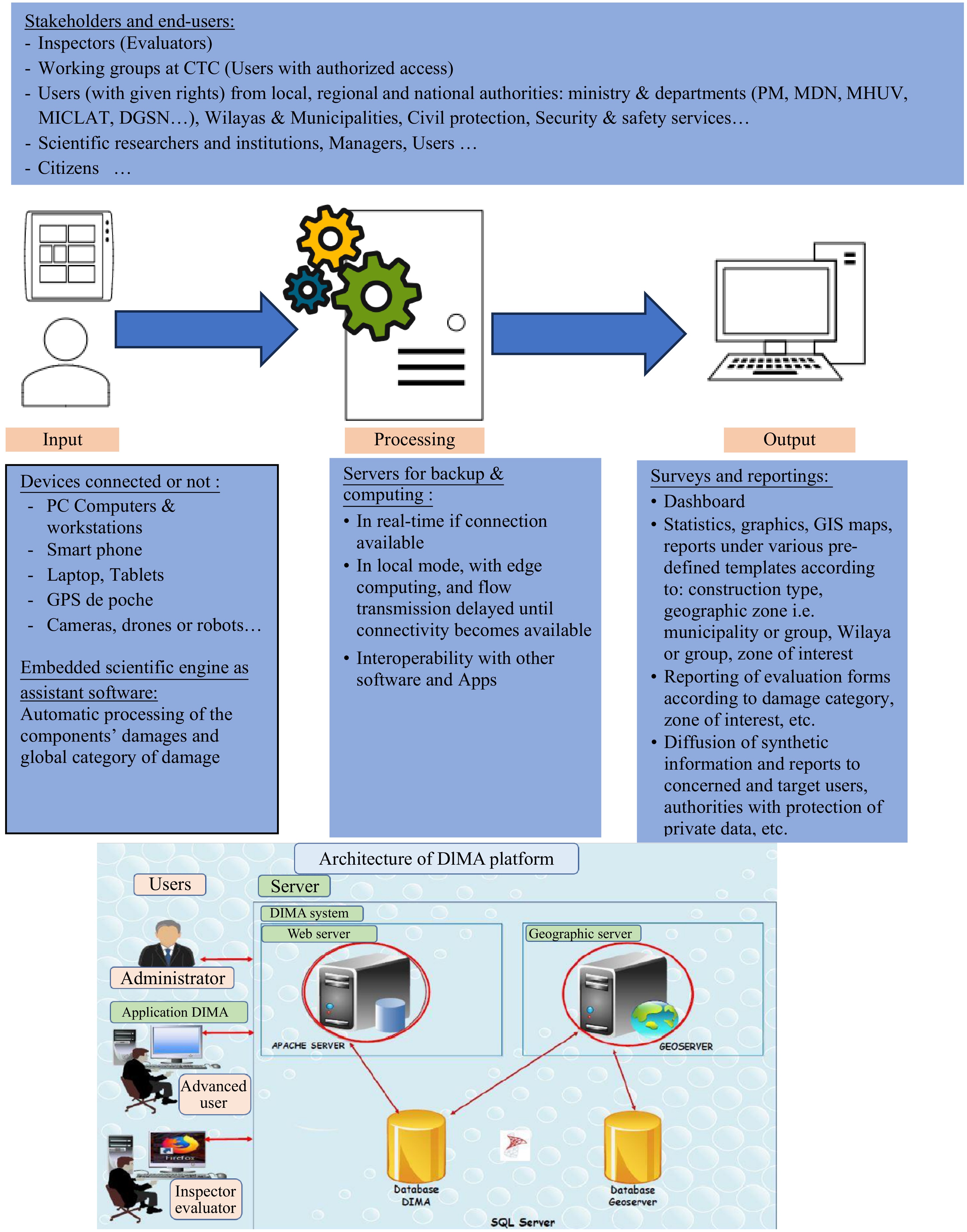
Figure 1.
General flowchart of DIMA platform and servers.
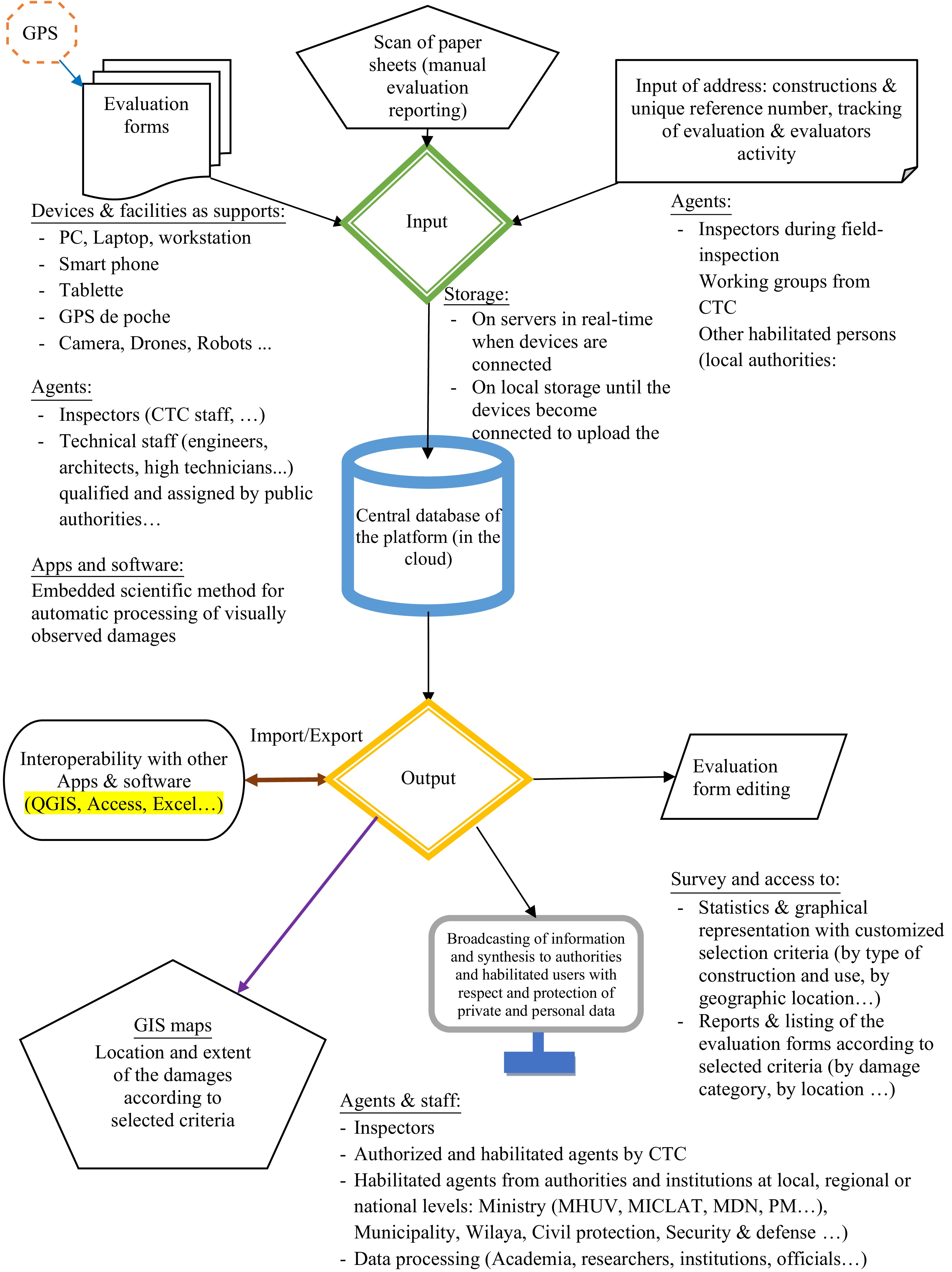
Figure 2.
Synthetic view of DIMA platform capacity.
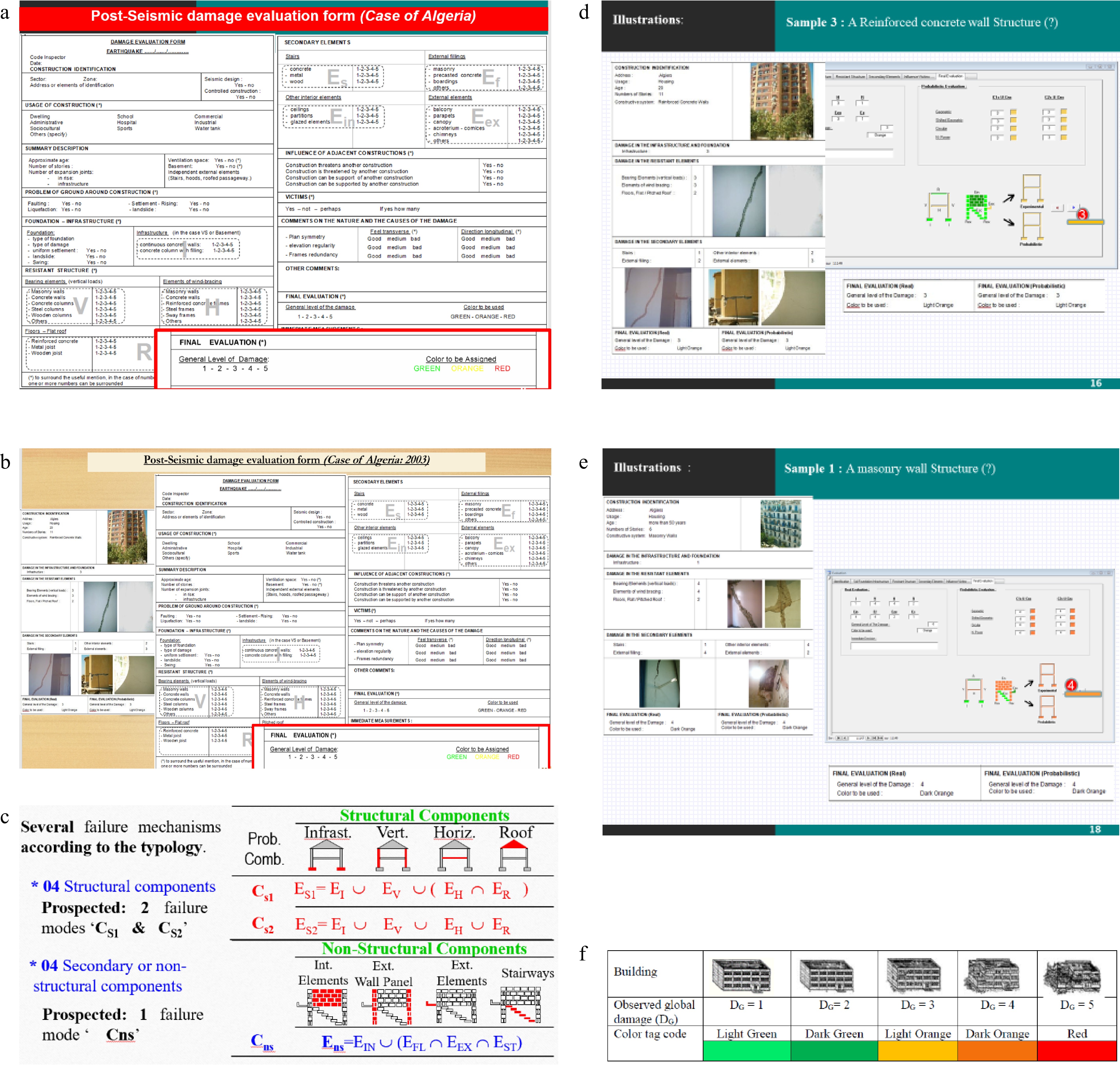
Figure 3.
Scientific methodology and engine embedded in DIMA platform. (a) Standard evaluation form in use. (b) Standard evaluation form in use: an example. (c) Events of failure combination: structural and non-structural components failures and damages. (d) Building damage category: D3. (e) Building damage category: D4. (f) Global damage category and corresponding tags.
● In the few hours or days after the occurrence of the triggering event (earthquake, explosion, fires, flooding with debris and mud, landslides etc.) as there is a need for a field inspection campaign: define the affected zones, considered afterward as zones of interest, and upload, on the server, the footprints of the buildings through digital maps (OpenStreetMap or Google maps, for instance) when available.
● Once the zones of interest (ZI) are identified: the whole set of buildings, located within the ZI area, is concerned by the field inspection. A quick visual technical inspection is scheduled with trained technical staff and engineers: a group of inspectors (two in general for cross check) is then assigned for each unit. Each unit is thus expected to be inspected and evaluated, and the assigned inspectors are notified with the list of units, and the timeline, for their field inspection.
● During the inspection: each group of inspectors starts the evaluation by clicking, on the pre-loaded GIS map (with the addresses and footprints of the buildings available on the digital device connected or not), or SketchUp, on the map, the polyline that represents the building footprint. The evaluation form, standard in use in the concerned country (Algeria, in the present case study), is then completed and the database is in real-time fed with the damage scored by the inspectors for each of the constitutive structural and non-structural components of the building. The inspectors can also take significative pictures with possible annotation when pertinent, make written remarks or comments, and upload them with the whole evaluation form on the server to populate the database. The scientific method embedded in the platform will then derive the global building's damage category, according to the scores observed for the component's damage. The global damage is then proposed to the inspectors who can confirm the automatic processing. They can also decide to score the global damage differently in case some singular situations are observed during the inspection. It's worth reminding that the global score of the damage should range within the five possible categories currently in use in Algeria, i.e., slight or no damage (category D1, tagged as light green), small damage (category D2, tagged as dark green), important damage (category D3, tagged as light orange), very important and serious damage (category D4, tagged as dark orange), extreme damage, and even collapse (category D5, tagged as red). These tags are painted therefore, at the entrance of the built units which is a meaningful code for the safety agents and the owners or users of the units: for green tags D1−D2, the units can remain in service, and access is allowed; for orange tags D3−D4, the units are evacuated and access is forbidden until future detailed technical evaluation of the residual capacity, for tag D5, the units are evacuated and will be demolished if it is not already the case during the disaster occurrence.
● In real-time during the evaluation campaign: the final scores and tags, as well as the whole evaluation form and annex documents are therefore uploaded on the server and populate the database. The access to the database, and to the synthetic or thematic reports and mappings are accessible on the server. This access to the contents and reports are tailored according to the rights assigned to the categories of users: inspectors themselves and the official institutions (institutions and authorities at local, regional, or national levels). They can have access to only parts or to the whole reports automatically generated, following pre-defined templates and formats for data interoperability. A real-time dynamic dashboard, fed as soon as a report and evaluation are terminated, displays the global damage extent and locations. It serves as support for decision-making and real-time survey by the authorities and all stakeholders.
● During the preparatory stages before field inspection: a virtual center for training and qualification is also developed. This virtual center has three modes: for beginners, a fixed guided training that covers the used terminology and pathologies until the final stage of inspection and scoring, a training mode with thematic topics, and the qualification mode as a certification delivered for those who can be part of the team for upcoming campaigns when there will be a future need. Artificial intelligence concepts are also used to build well-tailored and customized sessions to be proposed for the training and knowledge updates, adapted to each user and trainee. FAQ mode is also available as it gathers the questions and answers that are frequently expressed by the users.
-
The scientific methodology is based on research work[1,11]. Its basic concept consists of adequate combinations of failure events, of both the structural (main) and non-structural (secondary) constitutive components of the structure. This methodology has been calibrated and validated for 50,000 evaluation forms that have been collected during field inspection, in the aftermath of the earthquake that struck the Algiers region in 2003 (Boumerdès earthquake, 21/05/2003, Mw 6.8), see Fig. 3.
The results of the methodology have also been confirmed by additional methods, i.e. neural networks, fuzzy logic, and response surfaces with mathematical fitting and matching[1].
-
The platform has been tested under two modes, see Figs 4 & 5[38−41].
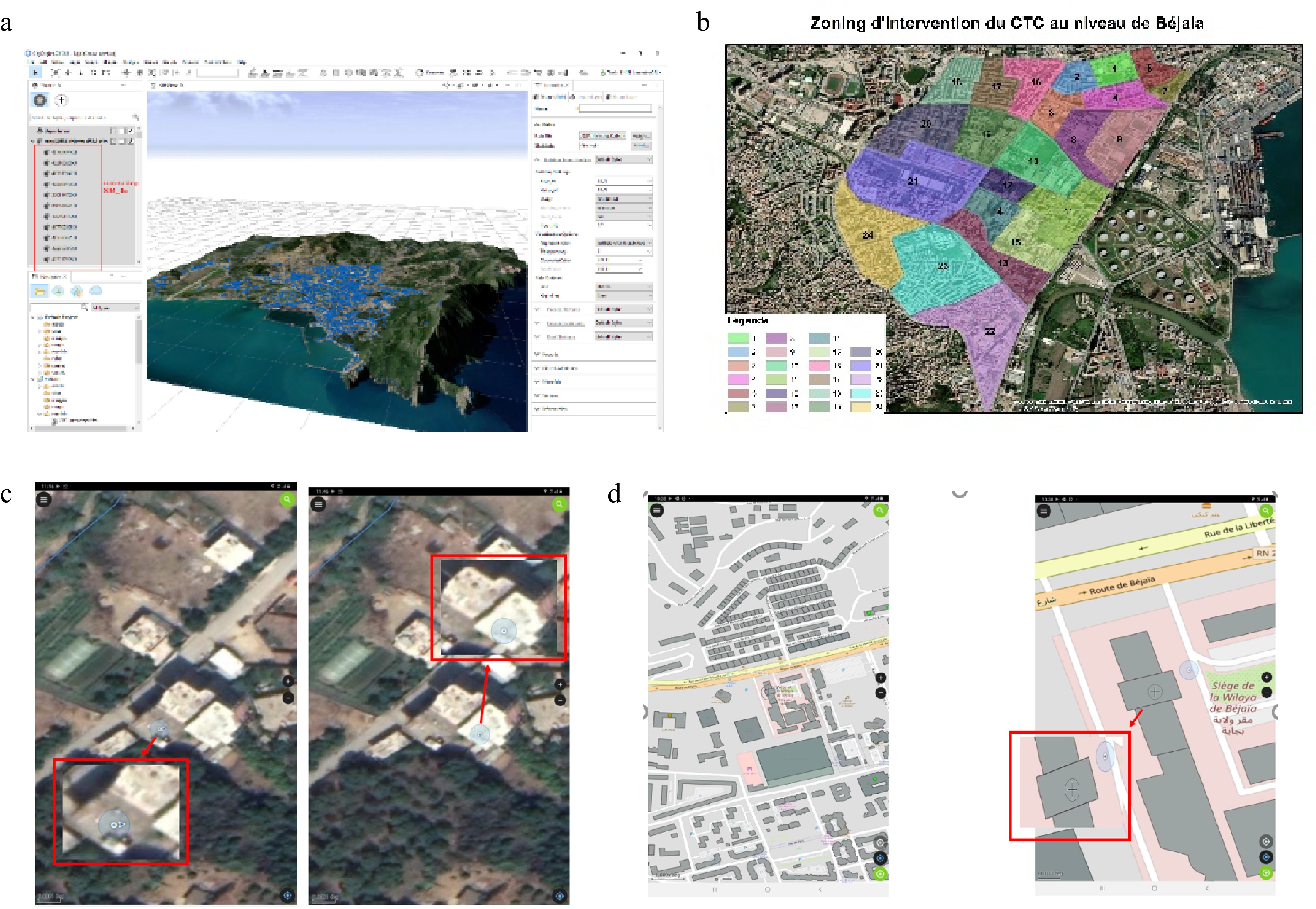
Figure 4.
Earthquake in Bejaia (Algeria) – zones of importance concerned by field inspection. (a) Download of the maps (satellite, OSM). (b) Zones of interest for the evaluation campaign. (c) Footprints and automatic selection. (d) Unit by click or polylign sketchup.
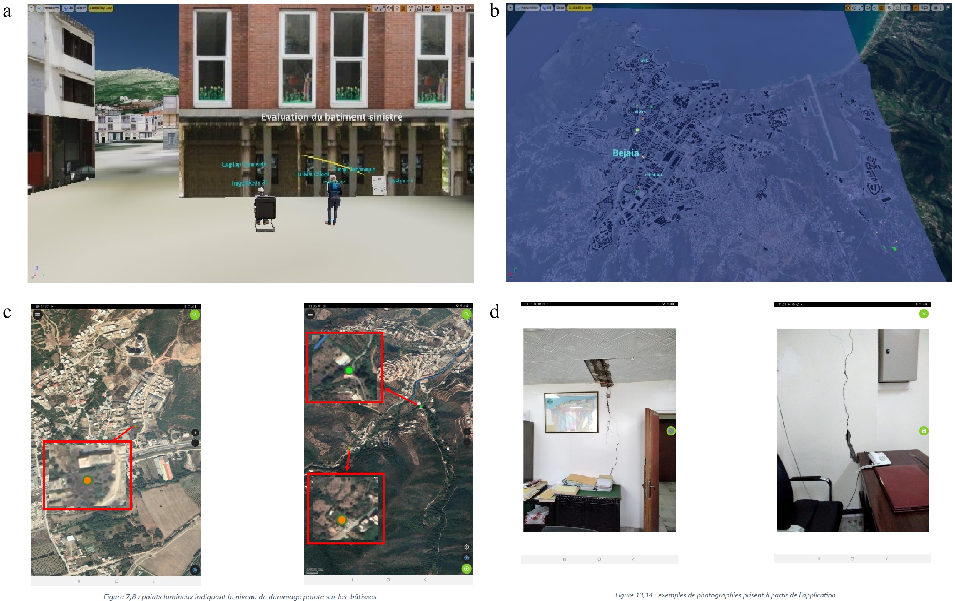
Figure 5.
Earthquake in Bejaia (Algeria) – field inspection and DIMA support. (a) Field evaluation and inspection. (b) Mapping of the damage extent and tags according to damage. (c) Evaluation and tag. (d) Photos and annotation for the database.
● An 'a posteriori' application: it has been performed a few months after the occurrence of an earthquake in a region impacted by a medium magnitude earthquake. Figure 4 shows the concerned zone with an earthquake that struck the region, with an epicenter located in the Mediterranean Sea a few kilometers in the northern vicinity of the city in Algeria: Béjaïa (2021, March 18, Mw 5.9). The digital map and the footprints of the buildings as well as the zones of importance are illustrated in Fig. 4. The mapping of the damage extent is depicted in Fig. 5.
● A stress-test in an 'a priori' situation (case of Mila earthquake, July−August 2020, NE Algeria): the teams test the platform and the trained staff in a hypothetical situation to foresee the operational difficulties and be ready in case any upcoming emergency occurs, see Figs 4 & 5.
-
The DIMA platform has been developed by a multi-disciplinary team of researchers, engineers, and developers, with multiple backgrounds that are mainly civil engineering, and computing sciences.
From the collected results in two a posteriori seismic events (Mila, 2020, July-August, Mw 4.6−4.8, located at the Algerian eastern part, at almost 350 km from Algiers; Béjaia, 2021, March, Mw 6.0) and during stress tests in various cities in order to train and prepare the technical staff (cities at different locations in Algeria: Annaba and Jijel in the eastern part, Béjaïa and Mahelma in the central part, and Aïn Temouchent in the western part)[16,17].
From the collected results, it can be seen that, see Figs 6−8:
● The automatic processing of the components' damage to derive the global damage category helps to assist the inspection teams. Some situations are difficult to handle since the global damage is at the frontier of two neighbor categories. The automatic processing assists the engineers in deciding on the global scoring.
● The digitization of the evaluation form provides more confidence and ease for the inspectors. The traditional evaluation of paper sheets is time-consuming. These evaluation forms had to be gathered at the end of the day and processed before a global synthesis became ready. The digitization and geo-referenced units under evaluation guarantee a real-time survey since the central server receives the digital forms that feed the database.
● The reporting is immediate and the decision-making is then dynamic and adapted continuously. The real-time dashboards and thematic reports are objective and quantitative supports for the authorities and stakeholders. It is helpful in estimating in real-time the need for sheltering, repair, and strengthening needed for the damaged constructions.
● The stress tests have been a good opportunity to train and prepare the technical staff for future potential evaluation campaigns. Usually, some evaluators were discovering the manual for evaluation and the paper evaluation form at the occurrence of the disasters. They were not trained enough and had to face heavy decisions sometimes under social pressure since the evaluation will sometimes result in the reallocation of people. Being trained and having at their disposal the digital platform and virtual training center gives more confidence and objectivity in the evaluation of the damaged structures.
● The training center appears now as a good opportunity to learn also the pathology of existing structures and evaluate their residual capacity before any disaster occurs. Hundreds of technicians and engineers have now received a training session and are from now on considered qualified to undertake evaluations for potential disasters that may arise: earthquakes, fires, flooding, industrial or gas explosions, landslides, etc. (see Fig. 6 & 7)
● Since the scientific engine is embedded as an App in the DIMA platform, there is now a possibility to improve the existing evaluation form and develop a new scientific generation of evaluation forms[42−44].
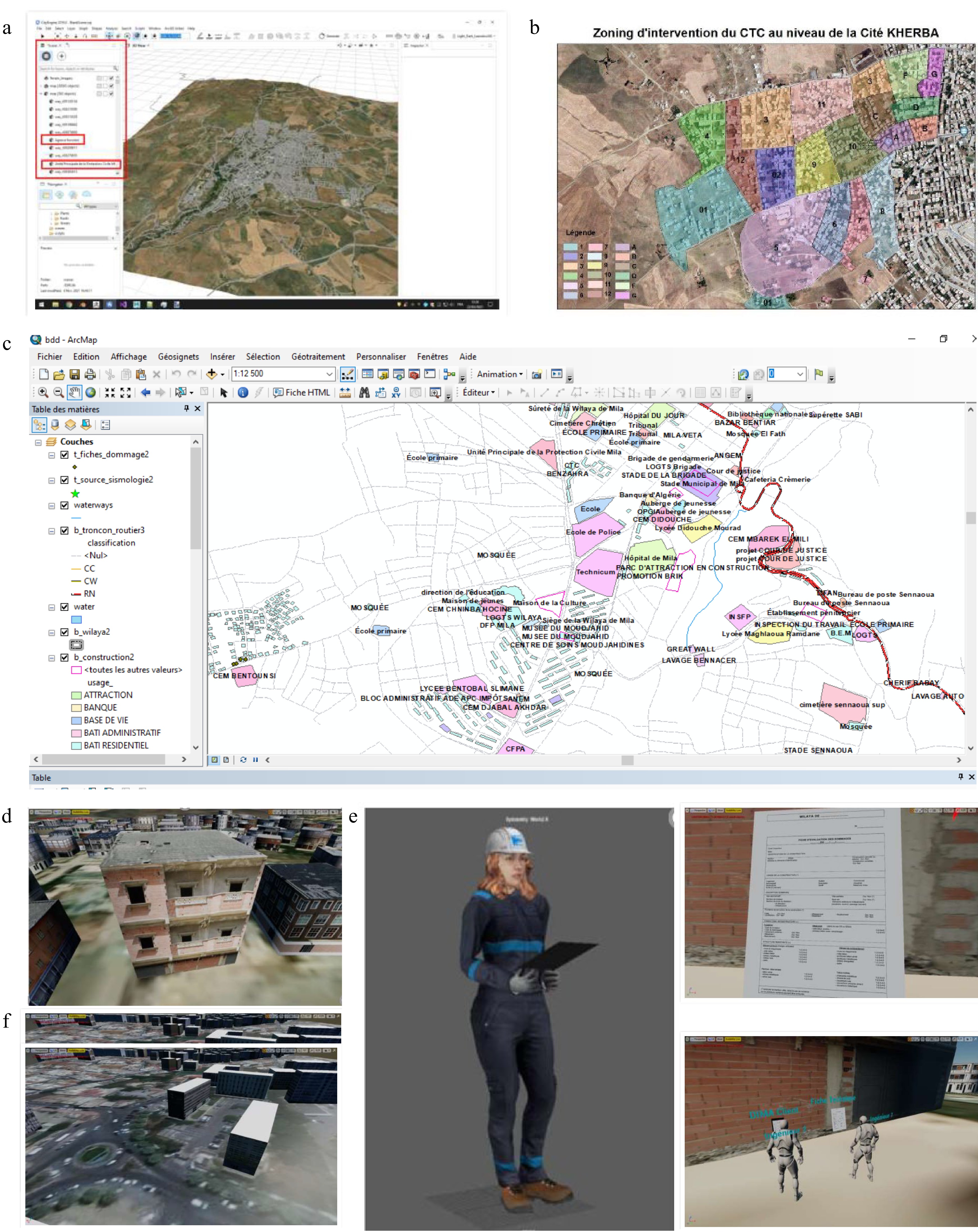
Figure 6.
Earthquake (Mila, July-August 2020, NE Algeria) – a posteriori evaluation. (a) Download of the maps (satelitte, OSM). (b) Zones of interest for evaluation campaign. (c) Footprints and automatic selection. (d) Unit to evaluate. (e) Simulation of evaluation. (f) Remote survey from the central authority for construction control (Algiers).
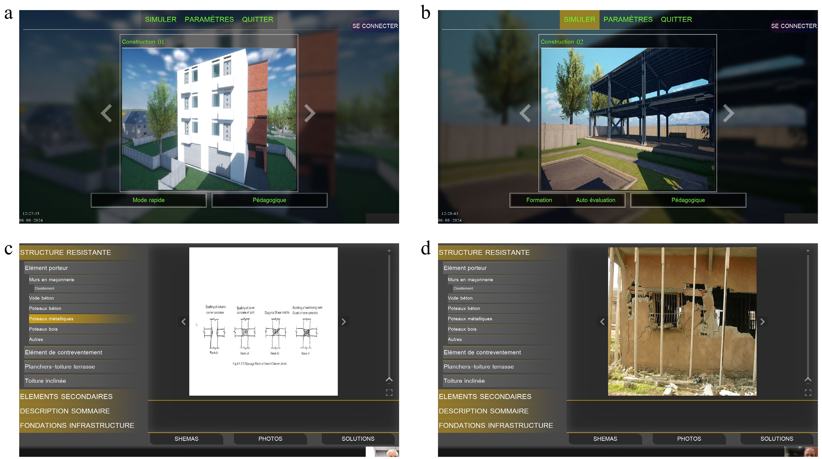
Figure 7.
DIMA virtual training and qualification centre with the purpose of learning, testing/validating, and qualifying. (a) Virtual training center: typology masonry. (b) Virtual training center: typology metal.(c) Pathology: damage of nodes. (d) Pathology: damage of walls.
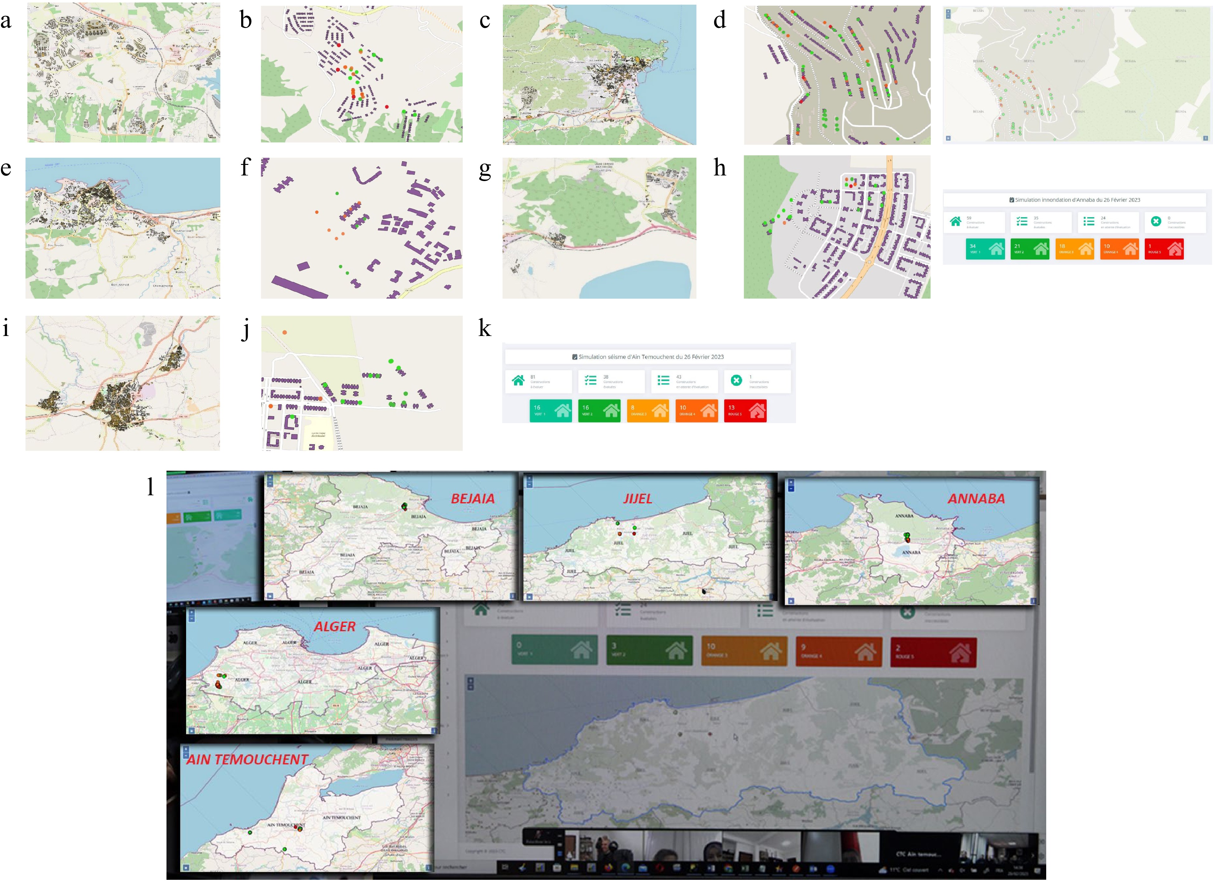
Figure 8.
Real post-seismic evaluations and stress tests run for preparatory purposes. (a) Stress-test in Sidi Abdallah (Algiers): footprints. (b) Damages extent. (c) Real earthquake (Béjaïa): footprints. (d) Damage extent. (e) Stress test (Jijel): footprints. (f) Damage extent. (g) Stress test (Annaba): footprints. (h) Damage extent and dashbord for real-time survey. (i) Stress test (Aïn Temouchent): footprints. (j) Damage extent. (k) Dashbord for real-time survey. (l) Training and qualification sessions (hundreds of engineers and technicians) with reporting from real earthquakes and stress-tests.
-
The present case study describes a digital platform that serves as a collaborative platform to handle emergency situations. It has been mainly developed to address the case of post-earthquake situations. It is also adapted to the case of any other emergency, besides earthquakes, since it can also handle any natural or technological disaster or NaTech disaster: floods, tsunamis, fires, explosions (industrial explosions or gas in some domestic situations when there are leakages), landslides, etc.
The platform consists of an adequate hardware architecture, i.e., servers as well as computing facilities and a specific database. This database contains GIS-referenced information on the built stock which is well adapted for the new trends in digital twins of territories, cities, facilities, infrastructure, and buildings.
In the case of buildings, each building is addressed with a unique reference and, at the occurrence of a disaster such as an earthquake, the impacted buildings are evaluated by trained staff: engineers and technicians.
A scientific embedded software, resulting from research work, allows us to derive the global category of damage according to the damage observed on the constitutive components of the concerned building: structural (main such as beams, columns, roofs, slabs, foundations, etc) or non-structural (secondary such as partition walls, stairs, balconies, etc) components. The inspectors are assisted by the scientific Apps on their connected (or non-connected device: laptop, tablet, smartphone, etc) to determine the global damage and classify it into slight damage (with no need to evacuate the construction), important (with the need to evacuate the building), and severe (with the need to demolish the construction).
The platform DIMA, for Digital Inspection and Monitoring Assistant, allows the real-time survey of the extent of the damage since the stakeholders and authorities, as well as the owners and users, know whether the construction should be kept in service or evacuated: emergency management consists then in evacuating the families and find appropriate provisional shelters and permanent reallocation.
Such a kind of real-time survey of the damage extends with synthetic and thematic mapping by category of construction, by category of damage, by geographic location, etc, and allows decision-making.
The platform has also developed a virtual training center so that the technical staff are trained and qualified to undertake future evaluation actions, since it learns the procedure in use for the evaluation, it can consult past evaluation forms and photos of pathologies, etc. The trained staff then feel confident and secure in undertaking evaluation actions without the risk of committing bias for underestimating or over-estimating the global damage, in particular under social pressure during real disasters.
For prospective purposes, the platform will integrate progressively the stock of the built environment on a large scale: cities, regions, and at large scale territory.
It will also integrate easily the new generation of evaluation forms as soon as they are calibrated and validated by the research work, that are ongoing.
Furthermore, the platform will propose in its improved version a set of strengthening and repair options with estimated cost and duration time for recovery of the damaged construction. This improved version might be also extended to the estimated subsidies given by the government to the victims according to the local laws and legislation. It might also add the status of victims living in the building (renter, owner, etc) according to official documents presented by the victims, and add the information if the building has CATNAT insurance. These additional aspects are very important for the reconstruction step and the recovery.
-
The authors confirm contribution to the paper as follows: Ahmed Mebarki: Supervised and coordinated the whole scientific work. He developed the theoretical aspects and methodology and contributed in selecting the case studies and analyzing the results. He drafted the paper. Boumediène Oukaci: He supervised and coordinated the whole work as the head of the national Algerian Center for Technical Control of the constructions. He has contributed in structuring the project and defining the strategy of the CTC for a national digital platform, that will help decision-making and technical field surveys of the constructions. Khaled Meziani: As head of the CTC, he approved the new developments of the virtual training center and contributed for the review and improvement of the present draft. Chahinez Alliche: Her main contribution concerns the GIS topics. Lakhdar Becheikh: His main contribution concerns the structural aspects of the damage evaluation and the development of the virtual training center. Hadjer Boumeshad: Her main contribution concerns the development of the mobile version of the inspection digital sheet, as well as the GIS features of the reporting and the synchronized dataflow with the server. Hadjer Boumeshad: Her main contribution concerns the development of the mobile version of the inspection digital sheet, as well as the GIS features of the reporting and the synchronized dataflow with the server. Ali Brahimi: As deputy head manager of CTC, he has driven the project progress and completion by implementing sound management and organizational practices. Houssem Ghiat: He contributed to the design of the dashboard and the verification of the implementation of the digital inspection assistant. Nabila Houmer: Her main contribution concerns the informatics aspects, i.e. the general architecture of the computing resources, the databases architecture, the server, and the interoperability of the data. Tarek Khiri: His main contribution concerns the informatics development, namely the virtual training center and the programming of the scientific computing engine embedded in DIMA platform. Hani Mebtouche: His main contribution concerns the informatics development of the front end of DIMA platform. Nabila Tahrat: As CTO, she has supervised the development of the mobile process sheet in accordance with the technical part and the procedure applied on site and designed the displayed information on dashboard. Younès Marouf: His main contribution concerns the informatics development of the front and back stages of DIMA platform. Amar Zekri: Her main contribution concerns the whole coordination of the computing aspects, i.e. the general architecture, the computing resources, the databases, the server, the interoperability of the data., and the validation of the methodology during the field case studies and stress tests. Sofiane Merrad: His main contribution concerns the informatics development for the virtual training center. All authors reviewed the results and approved the final version of the manuscript.
-
All data generated or analyzed during this study are included in this published article.
-
The authors declare that they have no conflict of interest. Ahmed Mebarki is the Editorial Board member of Emergency Management Science and Technology who was blinded from reviewing or making decisions on the manuscript. The article was subject to the journal's standard procedures, with peer-review handled independently of these Editorial Board members and their research groups.
-
§ (RIP) Passed away (February 2023), a few months after completion of DIMA project
- Copyright: © 2025 by the author(s). Published by Maximum Academic Press on behalf of Nanjing Tech University. This article is an open access article distributed under Creative Commons Attribution License (CC BY 4.0), visit https://creativecommons.org/licenses/by/4.0/.
-
About this article
Cite this article
Mebarki A, Oukaci B, Meziani K, Tahrat N, Becheikh L, et al. 2025. A case study for emergency management and urban resilience under seismic risks. Part III: an integrated digital platform for Digital Inspection and Monitoring Assistant (DIMA). Emergency Management Science and Technology 5: e003 doi: 10.48130/emst-0024-0028 

A case study for emergency management and urban resilience under seismic risks. Part III: an integrated digital platform for Digital Inspection and Monitoring Assistant (DIMA)
- Received: 10 August 2024
- Revised: 09 October 2024
- Accepted: 14 October 2024
- Published online: 11 February 2025
Abstract: The current paper presents a digital platform developed to manage the damage evaluation campaign for buildings in the aftermath of earthquakes, or any event such as industrial explosions or fires, landslides, floods, or tsunamis. Scientific software, embedded in this platform, automatically derives the building's damage category, according to the damage observed on its constitutive components, during a quick visual inspection performed by trained and technical staff and engineers. The scientific methodology is adapted to the case of the evaluation form in use in the concerned countries. For illustrative purposes, this study focuses on the case of the Algerian evaluation form, although it can be adapted to other countries since the evaluation forms are very similar and based on empirical principles or calibrated according to past accidents. During the field inspection, the qualified staff complete the evaluation form on connected or non-connected digital devices i.e. PC, tablet, smartphone, and even paper sheets. As soon as the digital devices are connected, an immediate real-time or slightly delayed survey of the damage extent on GIS-based maps, with automatic reporting, becomes available to the authorities, owners, and stakeholders, depending on specific rights to access the platform. This is helpful in decision-making regarding the rescue, relief, and sheltering for the inhabitants who have no further access to the houses, offices, markets, factories, schools, health facilities, etc., if these places have to be evacuated until they are further investigated and repaired or demolished. This study reports real applications during recent earthquakes and stress tests.