


-
As a site of global agricultural significance and a model of recycling–based agriculture, the Honghe Hani Rice Terraces (HHRT) have, over a history spanning 1,300 years, utilized a vertical elevation gradient exceeding 2,000 m[1]. Throughout this time, the Hani people developed an integrated hydrological system characterized by 'water storage in forests, flow regulation in villages, water retention and infiltration in terraces, and water system regeneration'[2]. This traditional system has not only supported essential ecosystem services, including soil retention, water conservation, and carbon storage, but also provided rich aesthetic, cultural, and ecological values for ethnic minorities such as the Hani, thereby contributing to regional food security and the preservation of cultural heritage[1,3,4]. In recognition of these contributions, the HHRT were designated as a Globally Important Agricultural Heritage System (GIAHS) by the Food and Agriculture Organization of the United Nations (FAO) in 2010, and inscribed on the World Heritage List by the United Nations Educational, Scientific and Cultural Organization (UNESCO) in 2013[5,6].
However, traditional terraced agricultural systems worldwide are increasingly under threat[7,8]. For instance, the Ifugao Rice Terraces in the Philippines have suffered degradation due to meteorological hazards, inappropriate organic fertilizer use, pest infestations, soil erosion, and pressures from tourism development[4,9]. Similarly, the Andean terraces of Peru have experienced a weakening of their water retention functions driven by climate change and land use change[10]. While in Japan, rice terrace areas have declined by nearly 40%, primarily due to low agricultural profitability, labor shortages, and changing dietary preferences[11]. Compared to these regions, the stability of the HHRT and their capacity to deliver ecosystem services are highly reliant on maintaining a dynamic equilibrium in land use patterns[3,4,12]. Nevertheless, increasing challenges such as climate–induced drought[1,13], landslides[14,15], urbanization, tourism development[15,16], and labor outflow[17−19] have led to substantial conversions of paddy rice areas into other land use types[20]. Existing studies often lack a systematic and quantitative assessment of the spatial–temporal dynamics of land use, thus constraining a comprehensive understanding of paddy rice loss and associated degradation mechanisms[17,20].
Land use changes threaten the stability of the HHRT agroecosystem by increasing the risk of ecosystem service decline and elevating ecological sensitivity[12,21]. Such changes undermine carbon storage capacity, diminish water conservation and soil fertility, disrupt nutrient cycling[4], and weaken the overall resilience of the terrace ecosystem[22,23]. Furthermore, changes in land use may damage the physical infrastructure of the terraces, obstruct hydrological networks, and reduce soil retention and water conservation functions[3,4,24]. These processes contribute to a decline in habitat quality and exacerbate sensitivity to geological hazards, soil erosion, and habitat degradation, thereby significantly amplifying the ecological vulnerability of the region. Despite these critical issues, research on the evolution of ecosystem services in the HHRT remains insufficient[12]. The coupling mechanisms between land use change and ecosystem service dynamics, as well as the feedback effects of ecological sensitivity on the recycling agriculture model, have yet to be systematically quantified[1]. These gaps limit efforts to evaluate HHRT resilience and hinder the development of effective adaptive management strategies.
Historical mapping offers a robust tool for monitoring and evaluating spatial–temporal changes in land use/land cover (LULC) and associated ecosystem services[20,25]. To ensure data reliability and align with policy cycles, this study adopts a decadal interval approach, producing LULC distribution maps for 1990, 2000, 2010, and 2020. Leveraging the Integrated Valuation of Ecosystem Services and Trade–offs (InVEST) model, we quantified the spatial-temporal evolution of ecosystem services and developed an integrated framework for ecological sensitivity assessment. This study seeks to address the following key scientific questions: (1) What are the spatial–temporal evolution patterns of LULC and ecosystem services in the HHRT? (2) How do ecosystem services spatially and temporally respond to land use changes? (3) What are the spatial differentiation characteristics of ecological sensitivity in response to land use changes? By elucidating the regulatory mechanisms governing the interactions between natural processes and human activities, this study provides new insights into enhancing the resilience of traditional terrace systems and offers guidance for the sustainable management of traditional ecological agroecosystems.
-
The HHRT are situated in the southern portion of the Ailao Mountains, located in southern Yunnan Province, China, spanning the geographical coordinates of 22°30'–23°30' N and 101°30'–103°30' E (Fig. 1). The total area encompasses 978.07 km2, covering Yuanyang, Honghe, Jinping, and Lvchun counties (four counties). Influenced by the southwest Indian Ocean monsoon, the region exhibits a subtropical mountain monsoon climate, with an average annual temperature of approximately 25 °C. Distinct vertical differentiation characterizes the hydrothermal conditions: arid and hot conditions prevail in the valley areas, where extreme temperatures can reach up to 42 °C, while the mountain peaks are marked by lower temperatures and increased precipitation, with average annual temperatures declining to 11.6 °C and annual precipitation in the southern Honghe River region reaching up to 1,397.6 mm[20]. Precipitation distribution is highly seasonal, with over 80% of annual rainfall occurring during the rainy season (May–October), corresponding closely to the irrigation demands of the terrace system. The region's landforms exhibit pronounced vertical stratification, transitioning from the deep river valleys of the Honghe River (lowest elevation at 339 m) through the terraced landscapes to the primary forests atop the Ailao Mountains (highest elevation at 2,865 m). This geomorphological structure supports a vertically integrated system of material and energy flow, characterized by 'forest water storage, village water piping, terraced field water use, and river system drainage', which has sustained a unique agricultural civilization for millennia.
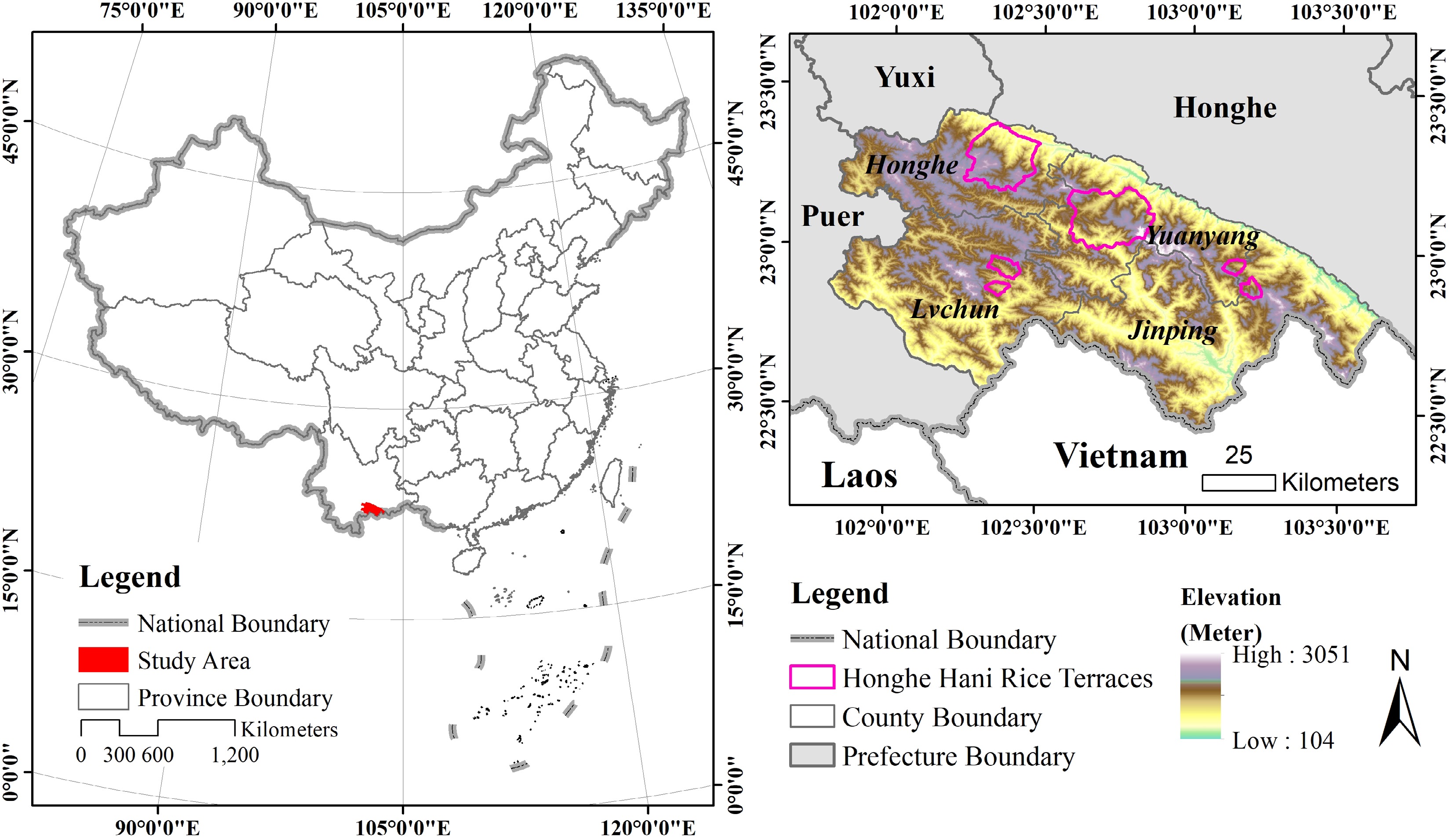
Figure 1.
Location and elevation range of the HHRT.
Data sources
-
This study integrates multi–source spatial–temporal datasets to evaluate land use change and ecosystem services within the HHRT (Table 1). It further compares these dynamics with those observed in the four counties, with the objective of elucidating the differential impacts of conservation policies and traditional land management practices on ecosystem functions. The integrated datasets include watershed boundaries, LULC data at a 30 m spatial resolution, digital elevation models (DEM), climatic variables (precipitation, evapotranspiration, rainfall erosivity), soil attributes (erodibility, depth to root–restricting layers), biophysical parameters (plant–available water capacity, nutrient retention potential), carbon pool estimates, and parameters representing ecological threats and sensitivities. All datasets were sourced from publicly available platforms and standardized to a common spatial resolution of 30 m to ensure consistency.
Table 1. Data input for land use map and ecosystem service evaluation.
Data Type Data source Spatial resolution Related model Watersheds Shape file http://ngcc.sbsm.gov.cn/article/xxfw/bgxz/ WY Land use type Raster Google Earth Engine[20] 30 m CS, SDR, WY, HQ,
GD, HD, SEDigital elevation model Raster http://www.gscloud.cn/ 30 m SDR, GD Reference evapotranspiration Raster http://www.cgiar-csi.org/data/global-aridity-and-pet-database Resampled to 30 m WY Depth to root restricting layer Raster Defined from land use types and InVEST user's guide Resampled to 30 m WY Annual average precipitation Raster http://www.worldclimate.com/ Resampled to 30 m WY Precipitation erosivity Raster https://gda.bnu.edu.cn/sypt/sjgx/tdlytdfgsjj/index.html Resampled to 30 m SDR, SE Soil erodibility Raster https://gda.bnu.edu.cn/sypt/sjgx/tdlytdfgsjj/index.html Resampled to 30 m SDR, SE Biophysical table CSV file Defined from literature and field work, including each land use types attributes of Kc (the plant evapotranspiration coefficient), load of nutrients, efficiency of nutrient retention, carbon density SDR, WY Plant available water fraction Raster Defined from land use types and InVEST user's guide Resampled to 30 m WY Carbon pools CSV file Defined from InVEST user's guide CS Threats table CSV file Defined from InVEST user's guide HQ, HD Sensitivity table CSV file Defined from InVEST user's guide HQ, HD Notes: WY, water yield. CS, carbon storage. SDR, sediment delivery ratio. HQ, habitat quality. GD, geological disaster. HD, habitat diversity. SE, sensitivity evaluation. The ecosystem service assessment system was established within the InVEST model framework, incorporating water yield, sediment delivery ratio, carbon storage, and habitat quality modules. Biophysical coefficients and threat weight parameters were calibrated based on a combination of literature review and field investigations, as summarized in Table 1. This integrated analytical framework provides a robust basis for comparing the ecological outcomes of conservation interventions between the HHRT and the four counties, while also enabling a comprehensive assessment of ecological degradation risks.
Ecosystem services selections
-
Based on the ecosystem type, ecological and environmental characteristics, research objectives, and data availability in the HHRT[26], four key ecosystem services were selected for evaluation: carbon storage, habitat quality, soil retention, and water yield.
Carbon storage
-
Carbon storage refers to the capacity of ecosystems to sequester atmospheric carbon dioxide through its absorption, fixation, and accumulation in vegetation, soils, and organic matter. In this study, the carbon storage capacity of the HHRT was assessed using the carbon storage module of the InVEST model. This module estimates total carbon storage by aggregating carbon stocks across four primary pools: aboveground biomass, belowground biomass, soil organic carbon, and dead organic matter[27]. The specific formula is:
$ {C}_{i}={C}_{a}+{C}_{b}+{C}_{s}+{C}_{d} $ (1) $ {C}_{total}={\sum }_{i}^{n}\left({C}_{i}\times {A}_{i}\right) $ (2) where, Ctotal is the total carbon storage (t), Ci is the carbon density of the i land use type (t·hm−2), and Ca, Cb, Cs, Cd respectively are above ground carbon density (t·hm−2), belowground carbon density (t·hm−2), soil organic carbon density (t·hm−2), and dead organic matter carbon density (t·hm−2), Ai is the total area of land use type i (hm−2).
Habitat quality
-
Habitat quality represents the capacity of an ecosystem to provide suitable conditions that support the survival and reproduction of living organisms, typically evaluated through a habitat quality index. In this study, habitat quality was assessed using the habitat quality module of the InVEST model, which integrates the influence of land use types, vegetation cover, and multiple threat factors (e.g., human activities, pollution) on habitat conditions[28]. The specific formula is:
$ \begin{array}{c}{Q}_{ij}={H}_{ij}\times \left[1-\left(\dfrac{{D}_{ij}^{z}}{{D}_{ij}^{z}+{K}^{z}}\right)\right]\end{array} $ (3) where, Qij is the habitat quality index of the grid i in land use type j (Extremely Low Quality Area = 0–0.2, Low Quality Area = 0.2–0.4, Medium Quality Area = 0.4–0.6, High Quality Area = 0.6–0.8, Extremely High Quality Area = 0.8–1), Hij is the habitat quality suitability of the grid i in land use type j, Dij is the stress level of thegrid i in land use type j, z is the model default parameter, K is the half–full and parameter.
Soil retention
-
Soil retention refers to the ecosystem's ability to preserve soil fertility and stability by mitigating soil erosion and promoting soil formation processes. The soil retention capacity of the HHRT was evaluated using the soil retention module of the InVEST model[29], by calculating the difference between potential soil erosion (under bare soil conditions) and actual soil erosion (under current land cover and management practices). The calculation formula is:
$ \begin{array}{c}{SD}_{i}={RKLS}_{i}-{USLE}_{i}\end{array} $ (4) where, SDi is the soil retention amount of the grid i, RKLSi is the potential soil erosion amount of the grid i, USLEi is the actual soil erosion amount of the grid i. In specific calculation, they are respectively calculated through the following formulas:
$ \begin{array}{c}{RKLS}_{i}=R\times K\times LS\end{array} $ (5) $ \begin{array}{c}{USLE}_{i}=R\times K\times LS\times C\times P\end{array} $ (6) where, R is the rainfall erosivity factor, K is the soil erodibility factor, LS is the topographic factor, C is the vegetation cover factor, P is the soil retention measure factor.
Water yield
-
Water yield refers to the quantity of water produced by an ecosystem over a given period, available for human consumption or other purposes, and is typically measured in millimeters or cubic meters. In the context of this study, water yield is defined as the difference between total precipitation and actual evapotranspiration within the study area. The water yield module of the InVEST model was employed to quantify water production, based on the principle of water balance, thereby supporting a spatially explicit assessment of water resource availability[30]. The calculation formula is as follows:
$ \begin{array}{c}{Y}_{\left(x\right)}=\left(1-\dfrac{{AET}_{\left(x\right)}}{P\left(x\right)}\right)\cdot P\left(x\right)\end{array} $ (7) where, Y(x) is the annual water quantity (m3) of grid cell x, AET(x) is the annual actual evaporation (m3) of grid cell x, P(x) is the annual precipitation (m3) on grid cell x.
Ecological sensitivity selections
-
In developing the ecological sensitivity evaluation framework, consideration was given to the distinct ecological and environmental characteristics as well as the intensity of human activities in the study region. The selection of evaluation factors adhered to the principle of regional adaptability, aligning with the natural geographical features, ecological background conditions, and socio–economic development needs of the HHRT[31]. Given the region's complex terrain and pronounced risks of geological hazards—such as frequent landslides and mudslides—and the accelerating land use changes induced by the Grain for Green Policy and urban–rural expansion[13,15,20,32], it is critical to establish a multidimensional ecological sensitivity evaluation system. Based on the characteristics of ecosystem service functions and vulnerability, three indices—geological hazard sensitivity, habitat degradation sensitivity, and soil erosion sensitivity—were selected for evaluation. The specific methodologies are detailed as follows:
Geological hazard sensitivity
-
The HHRT region, characterized by large elevation differences and steep slopes, is highly susceptible to natural disasters including landslides, mudslides, and rockfalls. These hazards are often triggered by heavy precipitation and natural weathering processes[3], posing significant threats to the structural stability of the terraces, water supply systems, and the integrity of the cultural landscape. In this study, key factors influencing geological hazard susceptibility—namely watershed slope, DEM, land use type, road distribution, and proximity to water systems—were identified based on the specific landscape characteristics of the HHRT and previous research findings[14], each factor was categorized into five sensitivity levels (Table 2). A comprehensive assessment of geological hazard sensitivity was conducted using a weighted formula, thereby elucidating the spatial distribution of geological hazard risks and providing a scientific basis for the development of early warning and risk management strategies. The calculation formula is as follows:
Table 2. Geological hazard sensitivity evaluation index system.
Index Extremely low sensitivity (0.1) Low sensitivity (0.3) Medium sensitivity (0.5) High sensitivity (0.7) Extremely high sensitivity (0.9) DEM (m) < 500 500–1,000 1,000–1,500 1,500–2,000 > 2,000 Slope (°) < 15 15–25 25–35 35–45 > 45 Buffer of roads (m) > 4,000 4,000–3,000 3,000–2,000 2,000–1,000 < 1,000 Buffer of water (m) > 3,000 3,000–2,000 2,000–1,000 1,000–500 < 500 LULC Buildings Croplands Grasslands Forests Paddy rice, water bodies Final result 0–0.25 0.25–0.35 0.35–0.45 0.45–0.55 0.55–1 $ DSj=\sqrt[5]{\prod_{i=1}^{5}{D}_{i}} $ (8) where, DSj is the geological hazards sensitivity index of the raster image element j (Extremely Low Sensitivity = 0–0.25, Low Sensitivity = 0.25–0.35, Medium Sensitivity = 0.35–0.45, High Sensitivity = 0.45–0.55, Extremely High Sensitivity = 0.55–1), Di is the value of the factor sensitivity level for factor i (Extremely Low Sensitivity = 0.1, Low Sensitivity = 0.3, Medium Sensitivity = 0.5, Extremely High Sensitivity = 0.9).
Habitat degradation sensitivity
-
The HHRT encompasses a diverse array of landscape types, including paddy rice areas, forests, croplands, grasslands, water bodies, and buildings. The sensitivity assessment of habitat degradation is predicated on the assumption that land use types exhibiting higher sensitivity to threat factors experience greater degrees of ecological degradation[28]. The calculation formula is as follows:
$ {D}_{xj}={\sum }_{r=1}^{R}{\sum }_{y=1}^{{Y}_{r}}\left(\frac{{\omega }_{r}}{{\sum }_{r=1}^{R}{\omega }_{r}}\right){r}_{y}{i}_{rxy}{\beta }_{x}{S}_{jr} $ (9) where, Dxj represents the degree of habitat degradation (Extremely Low Sensitivity = 0–0.2, Low Sensitivity = 0.2–0.35, Medium Sensitivity = 0.35–0.5, High Sensitivity = 0.5–0.65, Extremely High Sensitivity = 0.65–1), R is the number of stress factors, Yr is the total number of grids of all stress layers on the ground type layer, ωr is the weight of stress factors, i is the number of certain stress factors, irxy is the influence of stress R in grid x on grid y. The spatial relationship between stress factors and habitat types can be shown according to the index or linear correlation of ecological factors. βx is the level of protection of grid units, Sjr is the sensitivity of land use type j to stress factors i.
Soil erosion sensitivity
-
Based on the vertical zonality characteristics of the HHRT and the differences in soil retention functions among land use types, this study evaluated soil and water loss sensitivity using factors including precipitation erosivity, soil erodibility, topographic relief, and vegetation coverage rate[33]. A hierarchical evaluation index system was established accordingly. The calculation formula is as follows:
$ {A}_{i}=\sqrt[4]{{R}_{i}\times {K}_{i}{\times L}_{i}\times {C}_{i}} $ (10) where, Ai is the soil and water loss sensitivity index, Ri is the precipitation erosivity factor, Ki is soil erodibility factor, Li is topographic relief, Ci is the vegetation cover.
-
Land use changes in the HHRT and its four counties from 1990 to 2020 were analyzed through land use transfer matrices (Figs 2 and 3). The results indicated that forests consistently occupied the largest area, while water bodies covered the smallest. Significant changes were observed in forests, grasslands, croplands, and paddy rice areas. In the four counties, the area of paddy rice initially decreased from 838.83 km2 in 1990 to 379.61 km2 in 2010, before increasing to 508.32 km2 in 2020, representing an overall reduction of 39.40% (Supplementary Tables S1–S3). In the HHRT, paddy rice areas declined from 146.41 km2 in 1990 to 68.11 km2 in 2010, then rose to 110.06 km2 in 2020, with an overall decrease of 24.83% (Supplementary Tables S4–S6). From 1990 to 2020, the areas of forests, water bodies, and buildings expanded in both the four counties and the HHRT. In the four counties, forest areas increased by 1,449.02 km2 (19.56%), while grasslands and croplands decreased by 140.22 km2 (7.75%) and 995.05 km2 (56.27%), respectively (Supplementary Table S7). In the HHRT, forests, and buildings increased by 152.98 km2 (30.13%) and 3.87 km2 (35.93%), respectively, while croplands decreased by 120.58 km2 (52.08%) (Supplementary Table S8).
Figure 2.
Land use cover changes in the study area from 1990–2020.
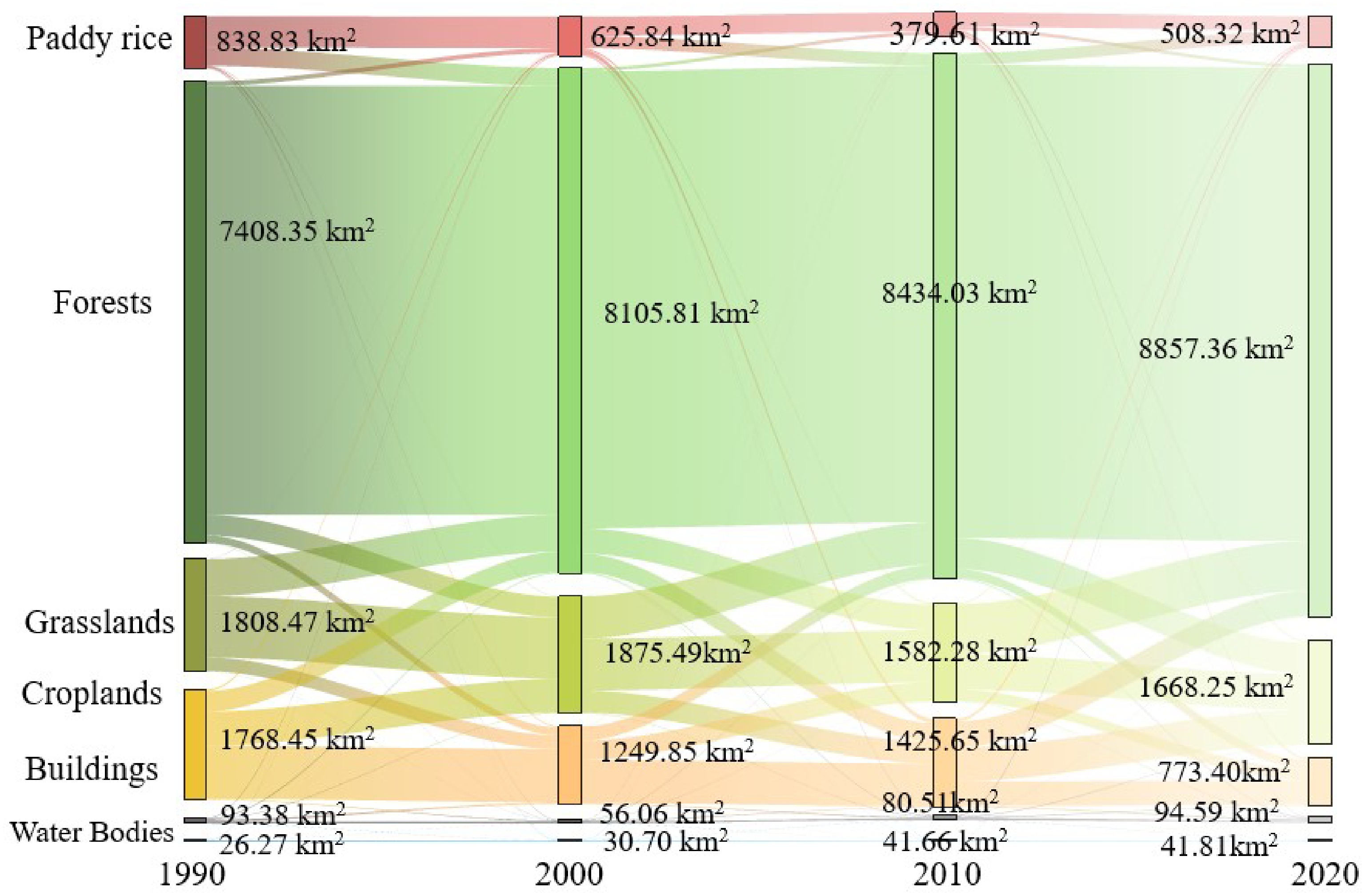
Figure 3.
Sankey diagram of the land use transfer matrix, 1990–2020.
Bidirectional land use conversions between paddy rice and other land types contributed significantly to the net loss of paddy rice areas. In the four counties, substantial conversions to forests, grasslands, and croplands resulted in net losses of 177.31, 94.28 , and 53.86 km2, respectively. Similarly, in the HHRT, the net paddy rice area losses were 15.76, 12.88, and 8.32 km2, respectively (Figs 3 and 4).
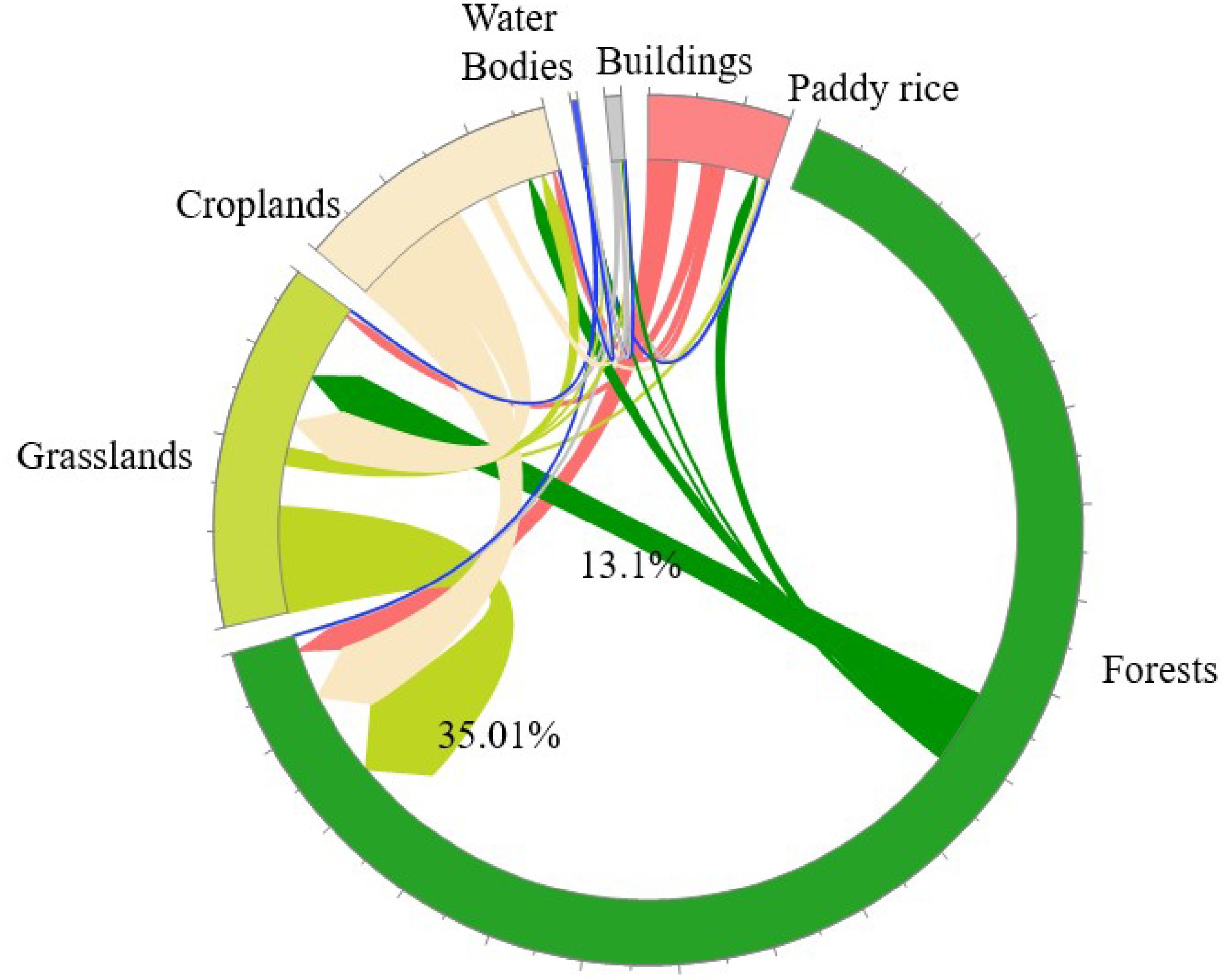
Figure 4.
Chordal diagram of land use transfer matrix, 1990–2020.
Spatial–temporal distribution changes of ecosystem services in the HHRT
-
Ecosystem services in the HHRT experienced significant changes from 1990 to 2020 (Fig. 5). Carbon storage in both the HHRT and the four counties increased by 16.61% and 12.22%, respectively. This increase is primarily attributed to the expansion of forest areas, where carbon storage rose by 32.60% and 21.03%, respectively. In contrast, carbon storage associated with paddy rice and croplands declined: by 26.66% and 51.95% in the HHRT, and by 42.06% and 57.07% in the four counties, respectively.
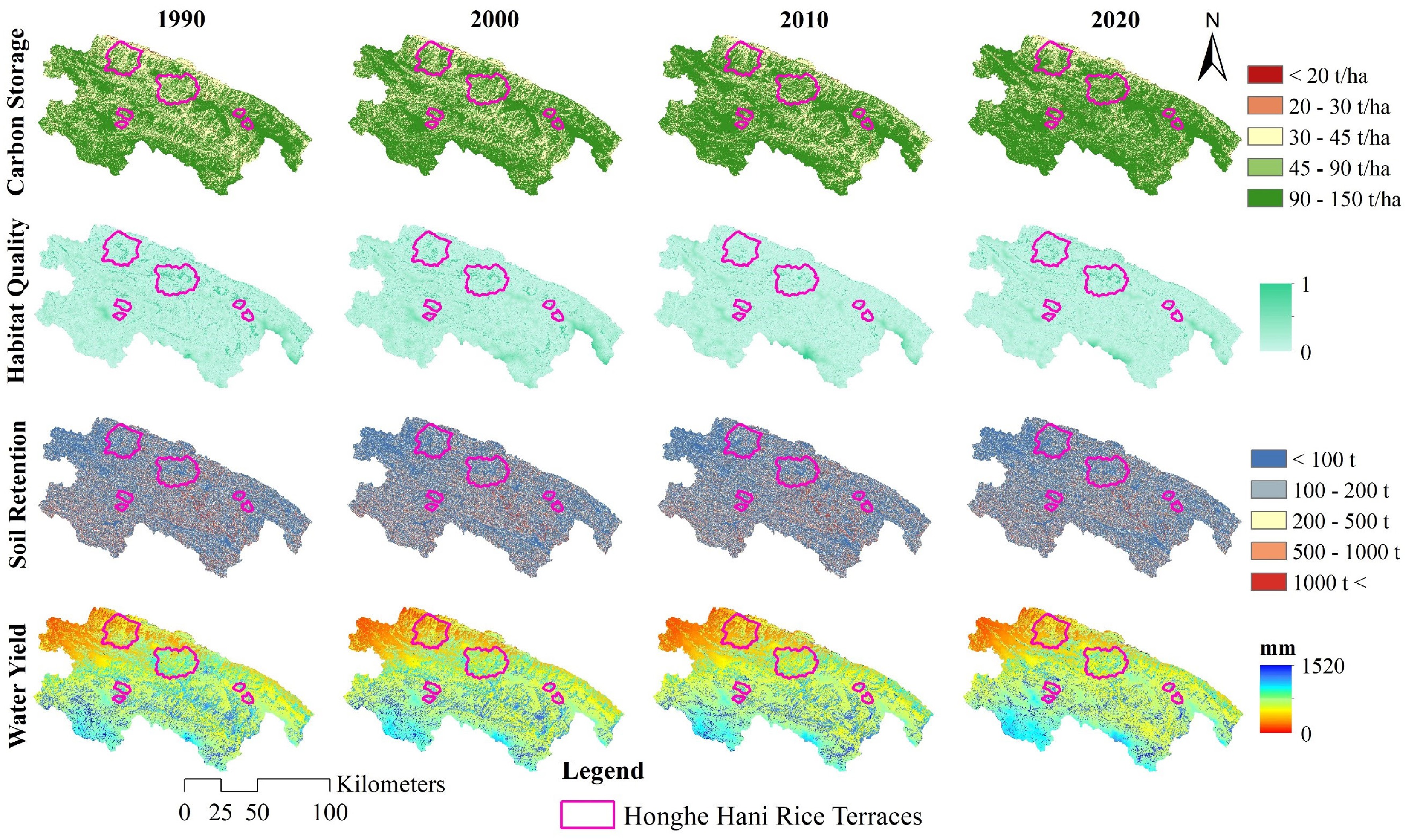
Figure 5.
Spatial distribution of ecosystem services in the HHRT, 1990–2020.
Habitat quality generally declined over the same period. In the HHRT, low–quality habitat areas expanded from 45.84% in 1990 to 59.58% in 2020, although extremely low–quality areas decreased from 22.67% to 11.75%. Similarly, in the four counties, low–quality areas grew from 55.77% to 67.02%, while extremely low–quality areas contracted from 15.60% to 7.28%. The total soil retention decreased by 14.43% in the HHRT and 12.63% in the four counties. In the HHRT, except for forests, all land types saw a decline in soil retention; croplands and paddy rice decreased by 65.89% and 31.83%, respectively. Similarly, in the four counties, cropland and paddy rice soil retention declined by 70.78% and 46.13%, although forests and water bodies exhibited slight increases. Water yield services also decreased during this period, with an 11.74% reduction in the HHRT and a 9.56% reduction in the four counties. In the HHRT, water yield from croplands and paddy rice fell by 55.34% and 24.79%, respectively, while forests increased by 26.26%. In the four counties, water yield from croplands and paddy rice decreased by 58.74% and 41.72%, respectively, and forests increased by 16.03%.
Ecological sensitivity changes in HHRT
-
The ecological sensitivity of the HHRT has increased markedly. From 1990 to 2020, the areas classified as having high and extremely high geological hazard sensitivity expanded by 12.49% and 38.82%, respectively—rates significantly higher than those observed across the four counties (9.63% and 14.35%). In the HHRT, areas of extremely low, low, and medium sensitivity declined, with low sensitivity areas experiencing the most notable reduction of 17.69 km2 (Fig. 6).
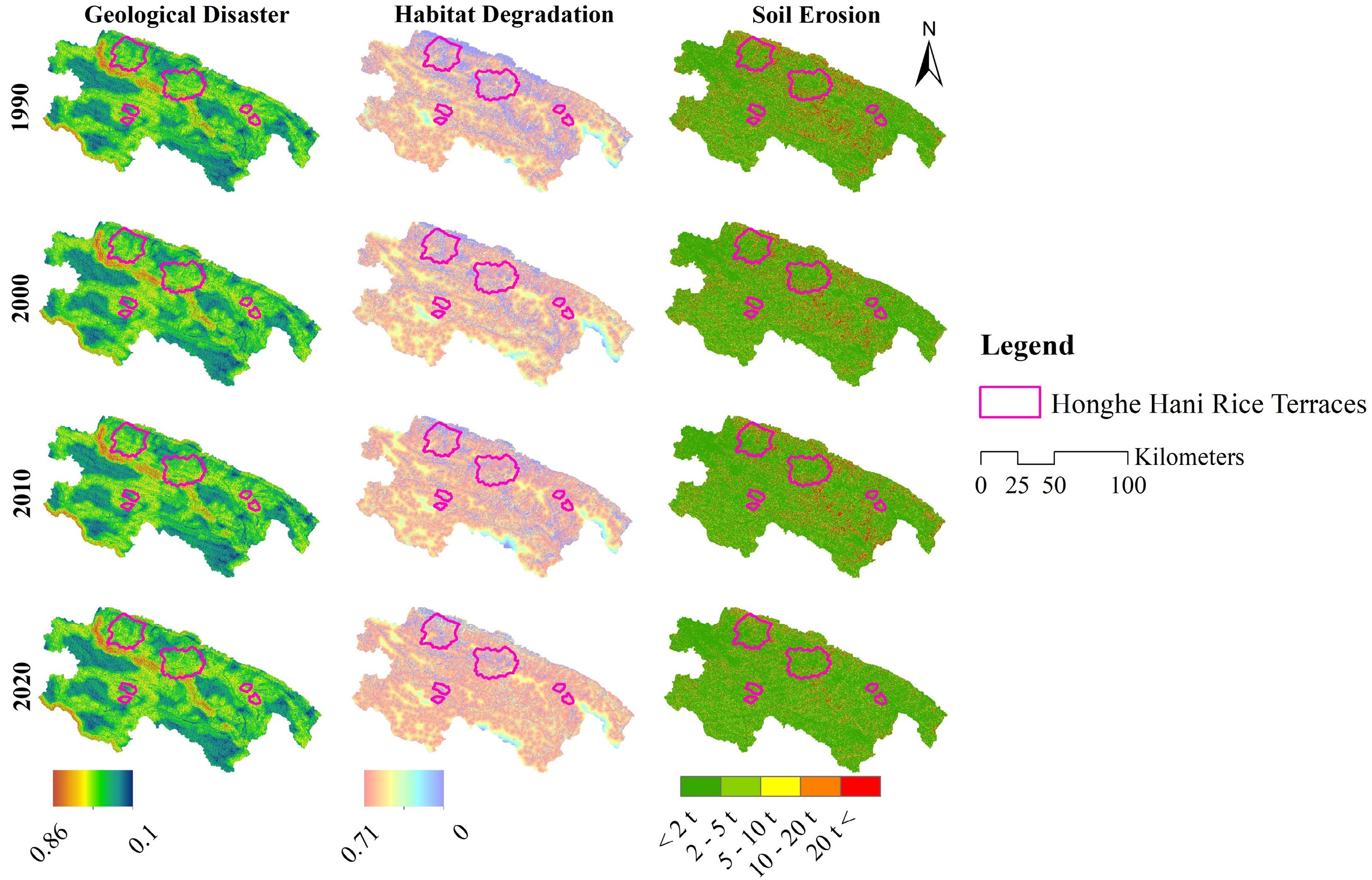
Figure 6.
Changes in ecological sensitivity of the HHRT, 1990–2020.
Habitat degradation sensitivity also intensified significantly. Areas of extremely high sensitivity increased markedly, with the proportion rising from 37.49% to 49.75% between 1990 and 2020. Meanwhile, medium and low sensitivity areas (levels 1–2) declined. Similarly, in the four counties, extremely high sensitivity areas rose from 39.29% in 1990 to 50.70% in 2020, while high sensitivity areas remained relatively stable.
The sensitivity to soil erosion improved notably. In the HHRT, the total soil erosion decreased by 48.84%, from 6.76 × 10⁶ t in 1990 to 3.46 × 10⁶ t in 2020. This reduction was mainly driven by a significant decline in cropland losses, which fell by 3.07 × 10⁶ t, with their contribution rate dropping from 65.33% to 38.71%. Although forest soil erosion loss increased slightly by 3.06 × 10⁴ t, overall losses decreased. Notably, while paddy rice losses declined overall, a rebound occurred between 2010 and 2020, with an increase of 8.21 × 10⁴ t. Soil erosion sensitivity trends in the four counties mirrored those in the HHRT, with an overall decrease of 49.07%, largely due to cropland loss reduction, while forest soil erosion losses increased by 7.21 × 10⁴ t, and paddy rice losses similarly rebounded during the final decade.
-
The results demonstrate that between 1990 to 2020, land use in the four counties and within the HHRT underwent substantial changes. Although paddy rice areas initially decreased and later recovered in both regions, some areas were permanently converted to other land types. However, the HHRT exhibited relatively smaller fluctuations, suggesting a more stable terrace system and more effective conservation outcomes.
Land use change is intricately linked to a combination of natural pressures, policy interventions, and socio–economic developments. Among natural factors, droughts have exerted significant influence[3,20,34,35]. Notably, periods of increased drought frequency during 1988–1990 and 2009–2010 contributed to the large–scale conversion of paddy rice areas into cropland and grassland due to irrigation water shortages[36,37]. In addition, the compounded effects of landslides have exacerbated land degradation; Yuanyang County alone recorded 235 landslides in 2008, with 285 incidents reported across the HHRT in 2015[14,18,22]. Given the difficulty of restoring landslide–affected areas, substantial paddy rice losses and subsequent grassland expansions have occurred.
Policy interventions also played a critical role. The Grain for Green Program, intensified after 2000[4], mandated the reversion of paddy rice areas on slopes exceeding 25° to forest[23]. Considering that slopes within the HHRT range from 15° to 75°, this policy significantly influenced terrace abandonment. Following the designation of the HHRT as a World Heritage Site in 2013, ongoing urbanization and tourism infrastructure development further accelerated the conversion of paddy rice areas into buildings[3,16,38].
Socio–economic factors likewise contributed substantially. The traditional maintenance of terraces depends on labor–intensive irrigation management and bund repairs. However, declining agricultural incomes and the migration of young laborers have weakened terrace management, leading to the gradual transformation of paddy rice areas into grasslands and cropland[1,17,32]. Following the HHRT's World Heritage designation, local policies prohibited terrace abandonment and damage[15], and the introduction of high–yield hybrid rice varieties[3,16] aided in increasing paddy rice coverage. Nevertheless, these measures have not fully offset the cumulative net loss of paddy rice areas.
Ecological impacts of land use change
-
The characteristic 'forest–village–terrace–water' landscape structure underpins key ecosystem services by facilitating vertical flows of water, nutrients, and energy, thus maintaining soil retention, biodiversity, water supply, and climate regulation functions[1,3,12]. However, land use changes have disrupted this integrated system, negatively affecting ecosystem services and increasing ecological sensitivity[12].
Between 1990 and 2020, both the HHRT and the four counties exhibited marked changes in ecosystem service provision and ecological sensitivity, particularly with respect to geological hazard vulnerability and habitat degradation. Carbon storage improved across both regions, with forested areas within the HHRT making a significant contribution. Although habitat quality declined in both regions, the extent of high–quality habitat loss was substantially smaller within the HHRT.
While geological hazard sensitivity intensified in the HHRT, the implementation of comprehensive soil erosion control measures and forest conservation programs helped to partially offset declines in soil retention and water yield services in agricultural landscapes. Despite achieving a similar percentage reduction in total soil erosion to the HHRT, the four counties experienced substantial increases in soil erosion within forested areas. This anomaly was linked to the prevalence of forests on steep slopes, where terrain instability exacerbated erosion risks. These findings suggest that the HHRT maintained a more stable ecosystem service framework, owing to the synergistic effects of human management interventions and natural ecological recovery.
Natural environmental factors, particularly extreme droughts[22,36] and landslides[14] have driven the change of paddy rice areas into forests, croplands, and grasslands, thereby disrupting the 'forest–terrace–water' resource cycle and weakening soil retention functions. Tourism development and urban expansion have further accelerated the conversion of paddy rice areas to buildings, causing severe habitat fragmentation, biodiversity loss, and the decline of traditional agroecological systems[38]. These processes also diminished the hydrological regulation capacities of terraces by reducing their water yield functions[20], ultimately destabilizing the overall agroecosystem.
The Grain for Green Policy effectively promoted forest expansion, thereby enhancing carbon storage[39,40], improving runoff regulation, and reducing soil erosion sensitivity[41]. Nevertheless, the abandonment of paddy rice areas and inadequate maintenance of drainage ditches led to localized surges in soil erosion[12,17,38]. Additionally, demographic pressures and tourism development[12] have pushed farming activities onto increasingly steep slopes[42], expanding areas with extreme geological hazard sensitivity. Vegetation recovery remains difficult in these high–risk zones, leading to further declines in soil water functions. Simultaneously, the abandonment of paddy rice and encroachment by tourism–related activities along ecological corridors have intensified farmland edge effects[2,12,38] and accelerated the loss of native vegetation, expanding zones of high habitat degradation sensitivity. Studies by Hua et al.[38] and Fu et al.[43] further confirm that intensive tourism development within the HHRT region adversely affects surrounding ecological environments.
Recommendations
-
Land use changes in the HHRT have led to the degradation of agroecosystem services, highlighting the urgent need for an adaptive management framework that integrates land use optimization, ecosystem service enhancement, and ecological risk mitigation.
To address the degradation of paddy rice areas, ecological interventions should be prioritized. First, an integrated platform for real–time monitoring of meteorological, hydrological, and geological risks should be established to facilitate targeted restoration efforts in ecologically fragile zones. Given that the social governance practices of the Hani people play a crucial role in sustaining regional ecosystems[12], incorporating traditional ecological knowledge with modern monitoring technologies can promote a synergistic and resilient circular governance model. Second, improvements to the terrace irrigation infrastructure are essential to enhance drought resistance and water storage capacity[1], while the planting of soil conservation vegetation and shelterbelt forests around terraces and on surrounding hillsides can effectively mitigate soil erosion risks[41]. Additionally, the promotion of integrated agroecological models, such as the 'rice–fish–duck' system, can enhance biodiversity, improve soil fertility, and facilitate nutrient cycling[1]. Moreover, strict regulation of development activities in steep slope areas, ecologically fragile zones, and regions with high geological hazard sensitivity is necessary, including stringent controls on construction expansion and the proliferation of large–scale tourism infrastructure[12].
Cultural and economic incentives are also vital for the long–term sustainability of the HHRT. Establishing dedicated funds for terrace restoration, coupled with the promotion of high–efficiency agricultural models such as eco–agriculture and organic farming, can improve land use efficiency. Land transfer mechanisms should be encouraged to consolidate fragmented terraces for more effective large–scale management[44]. Furthermore, the integration of organic farming and eco-tourism can diversify local income sources, thereby incentivizing the return of younger generations to rural livelihoods. Finally, strengthening community participation and enhancing local awareness of disaster risks are essential components for building resilient socio–ecological systems[45].
Limitations
-
This study acknowledges several limitations in the analysis of land use change, ecosystem services, and ecological sensitivity in the HHRT. First, the absence of long–term, high–resolution remote sensing data, combined with the lag in digitizing traditional agricultural knowledge, constrains the ability to quantitatively assess the impacts of nonlinear factors such as the intensity of tourism development[43] and the intergenerational loss of traditional farming practices on ecosystem service dynamics[17]. Second, the evaluation framework employed in this study was based on a limited selection of seven indicators, which, while representative, does not fully encompass the complexity of ecological processes nor allow for real-time monitoring of ecosystem service dynamics. Finally, socio-economic drivers, including policy changes and economic development, were not fully integrated into the analysis of ecosystem service alterations[1], suggesting an area for further refinement. Addressing these limitations in future research will contribute to a more comprehensive and scientifically robust foundation for the ecological protection and sustainable management of the HHRT and similar traditional agroecosystems.
-
This study employed LULC change data (1990–2020), ecosystem service indicators, and ecological sensitivity assessments to investigate the drivers and ecological consequences of land use changes within the HHRT. The findings indicate that between 1990 and 2020, paddy rice areas in the HHRT experienced a continuous decline, driven by the combined influences of climate change and anthropogenic activities. The impacts of land use change on ecosystem services were heterogeneous: while carbon storage increased due to forest expansion, habitat quality, water yield, and soil retention services declined markedly as paddy rice areas were converted into forests, grasslands, and croplands. Ecological sensitivity analysis further revealed that land use changes significantly exacerbated habitat degradation and heightened the region's susceptibility to geological hazards, resulting in an expansion of high-sensitivity zones and indicating a reduction in ecosystem stability and resilience. These land use changes have weakened the ecological functions of the HHRT and disrupted the material cycling system inherent in the traditional 'forest–village–terrace–water' landscape structure. Overall, this study provides valuable insights into the conservation and sustainable management of similar Globally Important Agricultural Heritage Systems worldwide.
This work was financially supported by the Scientific Research Fund Project of Yunnan Provincial Department of Education (2024Y288), and the Major Science and Technology Special Programme of Yunnan Provincial Department of Science and Technology (202302AE090023).
-
The authors confirm contribution to the paper as follows: study conception and design: Zhang L, Yang W; data collection, analysis and interpretation of results, draft manuscript preparation: Zhang L, Song J; manuscript revision: Chen H, Yang W. All authors reviewed the results and approved the final version of the manuscript.
-
The datasets generated during and/or analyzed during the current study are available from the corresponding author Wei Yang upon reasonable request.
-
The authors declare that they have no conflict of interest.
- Supplementary Tables S1 Land use change matrix from 1990-2000 (km2).
- Supplementary Tables S2 Land use change matrix from 2000-2010 (km2).
- Supplementary Tables S3 Land use change matrix in the four county districts of the Honghe Hani Rice Terraces from 2010 to 2020 (km2).
- Supplementary Tables S4 Land use change matrix in the core area of the Honghe Hani Rice Terraces from 1990 to 2000 (km2).
- Supplementary Tables S5 Land use change matrix in the core area of the Honghe Hani Rice Terraces from 2000 to 2010 (km2).
- Supplementary Tables S6 Land use change matrix in the core area of the Honghe Hani Rice Terraces from 2010 to 2020 (km2).
- Supplementary Tables S7 Land use change matrix in the four county districts of the Honghe Hani Rice Terraces from 1990 to 2020 (km2).
- Supplementary Tables S8 Land use change matrix in the core area of the Honghe Hani Rice Terraces from 1990 to 2020 (km2).
- Copyright: © 2025 by the author(s). Published by Maximum Academic Press, Fayetteville, GA. This article is an open access article distributed under Creative Commons Attribution License (CC BY 4.0), visit https://creativecommons.org/licenses/by/4.0/.
-
About this article
Cite this article
Zhang L, Yang W, Song J, Chen H. 2025. Impacts of land use change on ecosystem service degradation within a traditional circular agroecosystem: a case study of the Honghe Hani Rice Terraces. Circular Agricultural Systems 5: e007 doi: 10.48130/cas-0025-0005 

Impacts of land use change on ecosystem service degradation within a traditional circular agroecosystem: a case study of the Honghe Hani Rice Terraces
- Received: 08 April 2025
- Revised: 01 May 2025
- Accepted: 06 May 2025
- Published online: 29 May 2025
Abstract: Amid ongoing socio–economic development and natural environmental changes, the paddy rice area within the Honghe Hani Rice Terraces has undergone substantial decline, resulting in significant imbalances within the agroecosystem. This study employs land use change mapping and ecosystem service evaluation models to assess the ecological impacts of land use changes on the agricultural system from 1990 to 2020. The findings reveal that the area of paddy rice decreased by a net total of 36.35 km2, representing a 24.83% reduction, with most of this area being converted into forest and cropland. Although forest expansion led to a 16.61% increase in carbon storage, the habitat quality declined overall due to the reduction in paddy rice areas. Specifically, the extent of lower-quality habitat areas expanded by 134.71 km2 (30.02%), while soil retention and water yield ecosystem services decreased by 14.43% and 11.74%, respectively. Areas exhibiting extremely high sensitivity to habitat degradation (32.71%), and geological hazards (38.82%) increased markedly, thereby posing substantial risks to the resilience of the terrace system. Conversely, the total area sensitive to soil erosion declined by 48.84%. These results demonstrate that land use change has adversely affected the traditional agroecosystem services of the Honghe Hani Rice Terraces. The study further proposes pathways for the optimization and conservation of traditional agroecosystem functions.
-
Key words:
- Honghe Hani Rice Terraces /
- Land use change /
- Ecosystem services /
- Ecological sensitivity