


-
Earthquakes pose significant global threats, necessitating effective risk reduction strategies. Recent seismic events in Morocco, notably within the Al Haouz province[1], underscore the urgency to rigorously assess and prioritize mitigation approaches tailored to the region's vulnerabilities. In response, our research aims to contribute insights into earthquake management, specifically addressing the challenges faced by the Al Haouz province in Morocco.
Earthquake management[2,3] and mitigation[4,5] have been subjects of extensive research and practical efforts over the years[6].
Biswas et al.[2] explore sustainable strategies for managing earthquake susceptibility in Bangladesh, influenced by natural factors (geological features, plate tectonics) and human factors (population growth, urbanization), utilizing geostatistical modeling and Geographic Information System (GIS) to develop a spatial susceptibility map, offering valuable insights for stakeholders in vulnerability assessments, mitigation strategies, spatial risk estimation, and disaster preparedness at national and global levels, with the overarching goal of contributing to the sustainability of lifestyle and livelihood patterns in earthquake-prone regions.
Hsu et al.[3] develop an event-based seismic hazard assessment and financial analysis model for Hi-Tech Fabs in Taiwan, addressing the low occurrence rate, significant losses, and high uncertainty associated with earthquake disasters. The model integrates knowledge from various fields, including earth science, seismology, risk management, structural engineering, insurance, financial engineering, and facility management. Utilizing data from site surveys, the model calculates event losses, average annual losses, and loss-exceeding probabilities, providing a comprehensive indicator, total earthquake risk cost, for selecting optimal risk management strategies, encompassing earthquake insurance premiums, average annual retained loss, and equivalent annual retrofit cost.
Basaglia et al.[4] analyze the reconstruction process of a town affected by the 2012 Northern Italy Earthquake, utilizing information from the town journal. It highlights relevant aspects, compares housing recovery with a nearby city, and proposes seismic mitigation strategies through a what-if scenario. Applying these strategies to a city sub-system, the study evaluates changes in buildings' vulnerability and expected damage using a novel methodology for urban-scale risk assessments. A cost–benefit analysis demonstrates the effectiveness of the proposed strategies, showing a substantial reduction in expected damage and socioeconomic impact, along with an overall improvement in the urban system's performance.
García-Ayllón et al.[5] introduce an innovative geostatistical post-earthquake analysis using GIS spatial statistical tools to assess various variables influencing observed damage in the city of Lorca, Spain, after the 2011 earthquake. Departing from traditional unidisciplinary approaches, the research provides a comprehensive framework to hierarchize the importance of different phenomena contributing to seismic risk. The analysis, based on a bivariate GIS assessment, correlates spatially the identified problems, such as inadequate building design, age of real estate, urban planning inefficiencies, and geological risk, with the evaluated levels of damage. The outcomes aim to inform an improved seismic mitigation strategy for better urban preparedness against future earthquakes.
Kreibich et al.[6] underscore the significance of transdisciplinary studies on water-related multi-hazards, highlighting collaborative efforts across diverse scientific disciplines to advance understanding, assessment, and management of simultaneous or cascading water-related hazardous events. The research emphasizes three key outcomes of such collaborations: structured comparative analyses across natural hazard fields, insights into human behavior dynamics influencing multi-hazard risks, and the development of adaptable risk management strategies to address the escalating challenges posed by climate change. Despite acknowledging funding challenges and publication pressures, the study asserts that intensive transdisciplinary collaboration has yielded innovative ideas crucial for enhancing practical risk management of natural hazards. The authors advocate for sustained funding, interdisciplinary education, improved assessment processes, and expanded research scope to foster continued progress in this field.
Much of the early research in earthquake management focused on structural engineering and the development of building codes and construction standards[7,8]. These efforts have significantly improved the seismic resilience of buildings and critical infrastructure[9].
Scientists and geologists have made considerable progress in assessing seismic hazards[10,11], mapping fault lines[12,13], and predicting earthquake probabilities[14,15]. This research is essential for understanding where and when earthquakes are likely to occur[16].
Research in this area has led to the development of early warning systems that can provide advance notice of impending earthquakes[17,18]. These systems rely on the rapid detection of seismic waves and have proven effective in some regions[19].
Educational campaigns and public awareness initiatives have been instrumental in preparing communities for earthquakes. Research in this domain has explored the effectiveness of various education and awareness programs[20,21].
Studies have highlighted the importance of community-level preparedness[22,23], including drills[24], evacuation plans[25], and community engagement[26]. Community-based research has emphasized the role of local organizations and leaders in disaster response[27].
Research has also delved into the policy and legislative aspects of earthquake risk reduction[28−30], including land use planning[31], zoning regulations[32,33], and building code enforcement[34,35].
Despite these valuable contributions, there are notable knowledge gaps that our research seeks to address. Existing studies often lack a unified and systematic framework for evaluating the relative effectiveness of various earthquake management strategies across diverse criteria. Decision-makers are frequently left without clear guidance on how to prioritize strategies and allocate resources effectively during earthquake risk reduction efforts. The current study research aims to fill these critical gaps by offering a structured and evidence-based approach to evaluating and prioritizing earthquake management strategies, specifically within the context of the Al Haouz province in Morocco. Through the application of the Multi-Criteria Decision Making-Analytic Hierarchy Process (MCDM-AHP) methodology, we provide decision-makers with a comprehensive tool for making informed choices and enhancing earthquake risk reduction efforts on a global scale. This research thus contributes to the existing body of knowledge by offering practical insights and solutions to address the complex challenges associated with earthquake mitigation and preparedness, pioneering a thorough evaluation of strategies in a region where such assessments have been notably lacking.
Our study addresses several key questions:
1. What are the relative priorities and weights assigned to different criteria when evaluating earthquake management strategies?
2. How do a wide range of earthquake management strategies perform when assessed against these criteria?
3. What are the implications of these findings for enhancing earthquake risk reduction and emergency preparedness efforts?
The present study's originality lies in the comprehensive evaluation using the Multi-Criteria Decision Making-Analytic Hierarchy Process (MCDM-AHP) methodology. The research employs the MCDM-AHP framework. This framework systematically ranks criteria and alternatives, providing decision-makers with a roadmap for effective resource allocation.
In the field of earthquake management strategy assessment, various MCDM models have been explored. While this study primarily employs the AHP due to its suitability for our research context, it is worth noting that other MCDM models, such as the Promethee, TOPSIS, or ELECTRE methods[36, 37], have also been applied in similar studies[38]. The choice of AHP over these other models was influenced by its structured hierarchy, transparency, adaptability, and sensitivity analysis features, which align with the complexities of earthquake risk reduction in Morocco. However, it is essential to acknowledge that different MCDM models may yield distinct results, and the selection of AHP is based on the research objectives and the specific challenges of earthquake management in this region.
After this introduction which gives an overview of the research motivation, existing research, and knowledge gaps, research questions, originality of this study, and practical implications, and methodology, the following sections provide an overview of earthquake distribution worldwide, seismic activity in Africa, the specific seismicity observed in Morocco, historical earthquakes in Morocco, and an examination of seismic hazards and risks in Morocco.
The research methodology of this paper provides an overview of the study area and the earthquake location and details the MCDM-AHP framework, the alternatives, and the criteria considered. Additionally, it explains why the AHP within the MCDM framework is the preferred method for rigorously assessing earthquake management strategies in Morocco and why it was chosen over other MCDM models.
The research findings of this paper include the pairwise comparison matrices between criteria and between alternatives that were used to derive the relative weights of criteria and the weighted sums of strategies.
The discussion section discusses the research findings, including an exploration of the criteria weights and a detailed analysis of the performance scores of earthquake management strategies. Moreover, it is dedicated to discuss the practical implications of these results for decision-makers in the aftermath of the recent Moroccan earthquake. Additionally, it addresses the limitations of the study and proposes future research directions, contributing to a more thorough understanding of the research context.
This paper also conducts a comprehensive comparative analysis of earthquake management strategy evaluations, focusing on our study in Morocco and juxtaposing its findings with diverse international studies, thereby highlighting both commonalities and distinctions in seismic risk reduction approaches.
This research also delves into the intricate relationship between earthquakes and climate change. This includes an examination of the direct impacts of climate change on earthquakes, the indirect impacts of climate change on earthquakes, and the impacts of earthquakes on the climate. These detailed discussions aim to shed light on the interconnected dynamics of seismic activity and climate change, enriching the overall interpretation of our research findings.
The conclusion section of this paper summarizes the study's contributions and limitations and provides practical implications for earthquake risk reduction efforts based on the research outcomes.
Through this comprehensive approach, our research aims to offer practical guidance to decision-makers, emergency responders, and policymakers involved in earthquake risk reduction. By systematically evaluating and prioritizing earthquake management strategies, we endeavor to enhance preparedness, mitigate the impact of seismic events, and safeguard the well-being of communities and critical infrastructure worldwide.
-
Earthquakes are a global phenomenon, with their occurrence intricately tied to the dynamic nature of tectonic plate movements. The worldwide distribution of earthquakes reveals a concentrated pattern along the boundaries of major tectonic plates. The Earth's lithosphere is divided into several plates, and earthquakes predominantly occur along plate boundaries, where these plates interact.
In the Pacific Ring of Fire, encircling the Pacific Ocean, earthquakes are particularly prevalent due to the presence of multiple tectonic plate boundaries. The boundaries between the Pacific Plate and other neighboring plates, such as the North American, South American, Eurasian, and Indo-Australian Plates, give rise to frequent seismic activity in regions like Japan, Indonesia, and along the western coasts of North and South America[39].
Figure 1 shows the worldwide distribution of earthquakes with a magnitude of 6.5 or greater from 2000 to 2023.
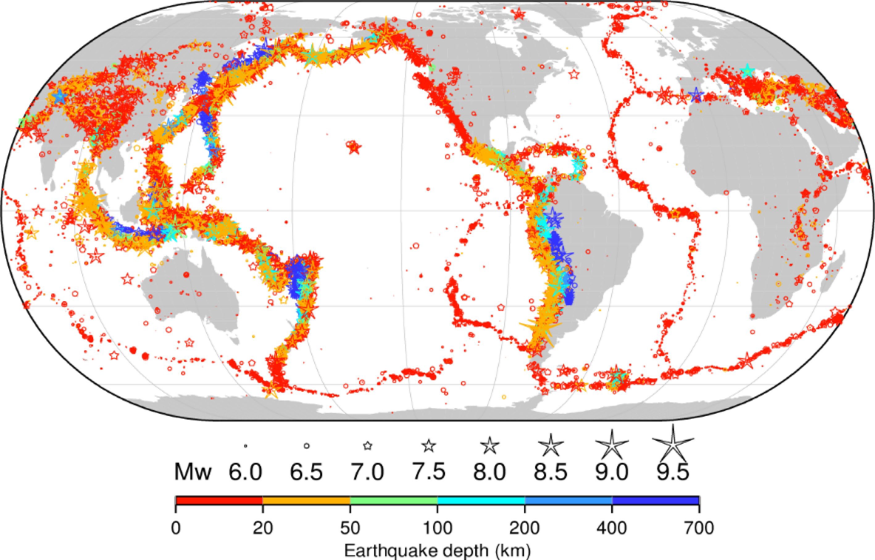
Figure 1.
The worldwide distribution of earthquakes with a magnitude of 6.5 or greater from 2000 to 2023. The figure shows that earthquakes are most concentrated in the following regions: The Pacific Ring of Fire, which is a belt of seismic activity around the Pacific Ocean; the Mediterranean-Alpine belt, which extends from the Atlantic Ocean through the Mediterranean Sea and into Asia; the East African Rift System, which is a series of faults that run through East Africa (Fig. 10); and the Mid-Atlantic Ridge, which is a mid-ocean ridge that runs through the Atlantic Ocean. These regions are all located at plate boundaries, where tectonic plates are moving and interacting with each other. This movement can cause friction and stress to build up, which can eventually be released in the form of an earthquake. It is important to note that this figure only shows earthquakes with a magnitude of 6.5 or greater. Smaller earthquakes occur much more frequently, but they are less likely to cause damage. Source: The International Seismological Centre[40].
Earthquake distribution in Africa
-
While Africa is not as seismically active as some other regions globally, it is not exempt from earthquake occurrences. The East African Rift System (EARS) is a notable tectonic feature in Africa, where the African Plate is splitting into the Nubian Plate to the west and the Somali Plate to the east[41]. This rift system extends from the Afar Triangle in the northeastern part of the continent down to Mozambique. The seismic activity associated with the East African Rift contributes to the earthquake distribution in Eastern Africa.
Figure 1 shows that earthquakes in Africa are concentrated in the following regions: The East African Rift System[41]; the North African Fold Belt; the West African Coastal Basin[42]; the Central African Shear Zone[43]; and the South African Fold Belt. These regions are all located at plate boundaries, where tectonic plates are moving and interacting with each other. This movement can cause friction and stress to build up, which can eventually be released in the form of an earthquake.
Seismicity in Morocco
-
In the context of Morocco, seismic activity is primarily linked to the tectonic interactions between the African and Eurasian Plates. The country is situated near the boundary where these plates converge, leading to the formation of various fault systems. The Atlas Fault System, running through the Atlas Mountains, is one such example. While Morocco may not experience earthquakes as frequently as some other seismically active regions, the potential for significant seismic events exists[44].
Figure 2 shows the location of earthquakes that have occurred in Morocco since 1900. The size and color of the dots on the map indicate the magnitude of the earthquakes. Larger and redder dots indicate larger earthquakes. The figure shows that earthquakes in Morocco are concentrated in the following regions: the Rif Mountains; the Atlas Mountains; and the Alboran Sea. These regions are all located at plate boundaries, where the African Plate and the Eurasian Plate are converging. This convergence is causing the rocks in these regions to fold and deform, which is leading to earthquakes.
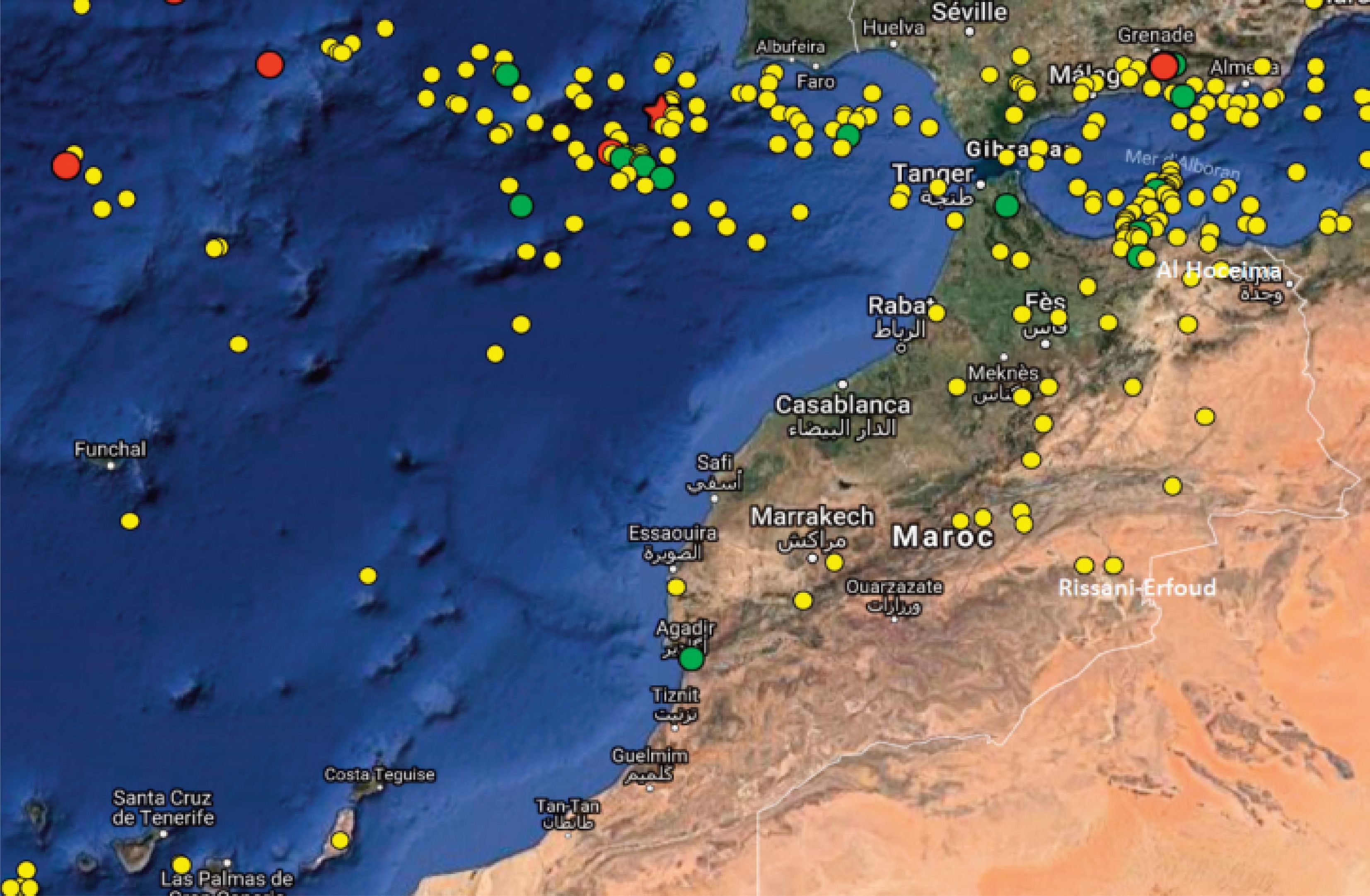
Figure 2.
A seismicity map of northern Morocco and its neighboring regions, showcasing earthquakes with magnitudes equal to or surpassing 5.0 on the Richter scale for the period spanning from 1900 to February 2017. The magnitude of each earthquake is represented by the size and color of the dots on the map, with larger and more red dots indicating earthquakes of greater magnitude. Yellow circles denote events with magnitudes ranging from 5.0 to 5.9, green circles represent events with magnitudes falling between 6.0 and 6.9, and red circles indicate events surpassing a magnitude of 7.0. Additionally, the red star on the map symbolizes the November 1, 1755, Lisbon earthquake. This map also shows that earthquakes are most common in the Rif Mountains and the Atlas Mountains. These regions are located on the edge of the African Plate, which is colliding with the Eurasian Plate. The collision of these two plates is creating stress and strain in the Earth's crust, which is leading to earthquakes. Source: Birouk et al.[45].
The Rif Mountains are located in northern Morocco. They are formed by the collision of the African Plate with the Eurasian Plate. This collision has caused the rocks in the Rif Mountains to fold and deform, causing earthquakes.
The Atlas Mountains are located in central Morocco. They are formed by the convergence of the African Plate and the Eurasian Plate. This convergence is causing the rocks in the Atlas Mountains to fold and deform, which is leading to earthquakes.
The Alboran Sea is located to the north of Morocco. It is a small sea that is located at the intersection of the African Plate, the Eurasian Plate, and the Iberian Plate. The convergence of these three plates is causing earthquakes in the Alboran Sea.
The most recent major earthquake in Morocco occurred on September 8, 2023. The earthquake had a magnitude of 6.8 and struck near the town of Amizmiz, about 45 miles southwest of Marrakech. The earthquake caused widespread damage[1].
The Moroccan government is taking steps to reduce the risk of earthquakes[45]. The government has developed a seismic hazard map[46], which identifies areas that are at risk of earthquakes. The government has also implemented building codes that are designed to make buildings more resistant to earthquakes[47]. However, more needs to be done to reduce the risk of earthquakes in Morocco. The government needs to invest in more earthquake-resistant buildings and infrastructure. The government also needs to educate the public about the risks of earthquakes and how to prepare for an earthquake.
Historical earthquakes in Morocco
-
The geological landscape of Morocco bears witness to a series of historical earthquakes that have significantly influenced the seismic risk profile of the region. The examination of past seismic events is crucial for understanding the recurrence patterns, magnitudes, and impact on communities. Several notable historical earthquakes have left a lasting imprint on the seismic history of Morocco.
Agadir Earthquake (1960)
-
Among the most devastating earthquakes in Morocco's recent history is the Agadir earthquake of 1960. Striking the coastal city of Agadir on February 29, this seismic event had a magnitude of 5.7 and resulted in catastrophic consequences. The earthquake caused widespread destruction, claiming thousands of lives and reducing much of Agadir to ruins. The aftermath prompted a reevaluation of seismic preparedness and laid the foundation for subsequent seismic risk mitigation strategies in the country[48,49].
Agadir is situated on the Atlantic coast of Morocco, southwest of the Atlas Mountains (Fig. 2). While the Atlas Mountains are known for seismic activity, Agadir is not directly on the plate boundary. However, it is still subject to seismic events, and its proximity to the Atlas Mountains contributes to its vulnerability to earthquake risks.
Al Hoceima earthquake (2004)
-
Another significant seismic event occurred in Al Hoceima on February 24, 2004, with a magnitude of 6.3. This earthquake highlighted the vulnerability of certain regions in Morocco to seismic activity. While not as destructive as the Agadir earthquake, it emphasized the importance of continuous efforts in seismic risk reduction and community resilience[50].
Al Hoceima is located in the Rif Mountains (Fig. 2), which are mentioned in the context of seismic activity in northern Morocco. The Rif Mountains, including the region around Al Hoceima, experiences relatively high seismicity.
Meknes earthquake (1755)
-
Looking further into Morocco's seismic history, the earthquake that struck Meknes in 1755 remains one of the most powerful earthquakes recorded in the country. With an estimated magnitude exceeding 7.0, it caused extensive damage to infrastructure and altered the urban landscape. The historical significance of this earthquake underscores the persistent seismic threat that Morocco faces[51].
Meknes is situated inland, to the west of the Middle Atlas Mountains (Fig. 2). Similar to Agadir, Meknes may experience seismic events, although it is not directly on the plate boundary. The seismic activity in these regions is influenced by the tectonic interactions between the African and Eurasian Plates.
Lessons learned and future implications
-
The seismic history of Morocco, marked by significant historical earthquakes, offers invaluable lessons that shape current and future seismic resilience strategies.
The devastation wrought by earthquakes, such as the Agadir earthquake in 1960[48,49] and the Al Hoceima earthquake in 2004[50], underscores the critical importance of architectural resilience. Lessons learned from these events have driven advancements in building codes and construction standards[47]. Implementing earthquake-resistant designs, securing furniture, and retrofitting vulnerable structures are pivotal measures for minimizing structural damage and protecting lives.
Historical earthquakes have highlighted the necessity of community preparedness. The Tetouan earthquake in 1930 and subsequent seismic events emphasized the role of public awareness and education in enhancing community resilience. Educational initiatives and regular earthquake drills are instrumental in ensuring that individuals and communities are well-prepared to respond effectively during seismic events.
The Meknes earthquake of 1755[51] serves as a reminder of the importance of early warning systems. Advances in technology now allow for more sophisticated seismic monitoring and alert systems. Integrating such technologies into the seismic risk management framework provides crucial seconds to minutes of warning, enabling proactive responses and reducing the impact of earthquakes.
Lessons from historical earthquakes stress the need for effective interagency collaboration. Coordinated efforts among government agencies, emergency services, and local authorities enhance the efficiency of response and recovery operations. The Al Hoceima earthquake in 2004 underscored the significance of seamless coordination to address immediate needs and implement long-term recovery measures.
Understanding the environmental impact of earthquakes is essential for sustainable recovery. The global perspective of seismicity, coupled with local experiences, emphasizes the importance of incorporating environmental considerations into post-earthquake recovery plans. Balancing reconstruction efforts with environmental preservation contributes to long-term resilience.
Looking forward, these lessons guide the formulation of future seismic risk mitigation strategies in Morocco. Continued research into seismic hazards, advancements in technology, and ongoing public education are crucial components. Integrating lessons learned in urban planning, infrastructure development, and policy formulation ensures a proactive approach to seismic risk reduction. As Morocco strives to build a more resilient future, the synthesis of historical knowledge with contemporary strategies forms the cornerstone of comprehensive earthquake management.
Understanding the worldwide distribution of earthquakes, particularly in Africa and within the specific geological context of Morocco, is essential for contextualizing the seismic risk faced by the Al Haouz province and the broader nation. It provides a broader perspective on the global seismic landscape and aids in the development of targeted earthquake management strategies tailored to the unique seismic challenges of the region.
Seismic hazards and risks in Morocco
-
The seismic hazard in Morocco is a result of the geological setting and tectonic activity in the region[47]. The country is prone to both shallow and deep earthquakes, with the potential for significant ground shaking (Fig. 3). The distribution of seismic hazard is not uniform across the nation, and certain regions, including the Al Haouz province, maybe more susceptible to seismic events. Various fault systems, such as the North Anatolian Fault and the Atlas Fault System, contribute to the seismic hazard in different parts of Morocco. Figure 3 shows the distribution of seismic hazards in Morocco. The different colors represent the different types of seismic hazards and risks: Red: Ground shaking (i.e., very high risk); Orange: Liquefaction (high risk); Yellow: Tsunamis (i.e., medium risk); Light Yellow: Seiches (i.e., low risk). The assessment of seismic hazard involves consideration of factors such as historical seismicity, fault distribution, and ground acceleration values. Morocco has experienced notable earthquakes in its history, and understanding the seismic hazard is crucial for implementing effective earthquake management strategies.
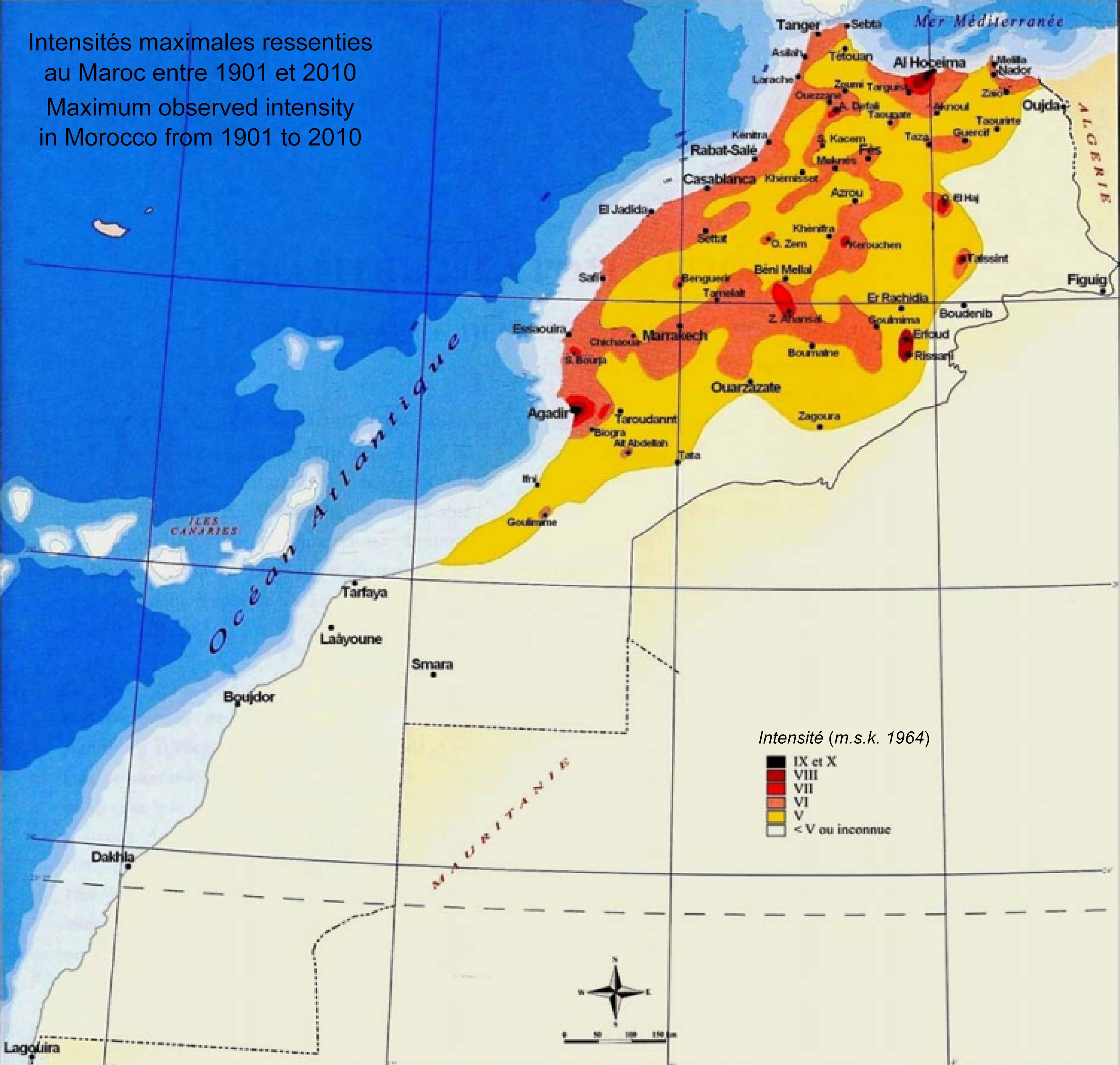
Figure 3.
The portrayal of seismic hazards across Morocco. It is depicted through various colors, each corresponding to distinct types of seismic hazards: Red indicates ground shaking (i.e., very high risk); Orange represents liquefaction (i.e., high risk); Yellow denotes the potential for tsunamis (i.e., yellow risk); and light yellow signifies the occurrence of seiches (i.e. low risk). The figure shows that all four types of seismic hazards are present in Morocco, but that ground shaking is the most widespread hazard. Ground shaking is a hazard in all parts of Morocco, but it is most severe in the Rif Mountains and the Atlas Mountains. Liquefaction is a hazard in areas where the soil is loose and waterlogged. This type of soil is common in coastal areas and along river valleys. Tsunamis are a hazard in coastal areas. Seiches are a hazard in lakes and reservoirs. The figure also shows the location of some of the most significant seismic hazards in Morocco. These include: The Rif Mountains; the Atlas Mountains; and the Alboran Sea. Source: Cherkaoui & El Hassani[52].
Seismic risk, the potential for damage and loss resulting from earthquakes, is a combination of both the seismic hazard and the vulnerability of the exposed elements, such as buildings, infrastructure, and communities. In the Al Haouz province and other regions of Morocco, seismic risk is influenced by factors such as population density, building construction practices, and the level of preparedness for earthquake events.
The seismic risk assessment considers the potential impact of earthquakes on structures and communities, taking into account the susceptibility of buildings to seismic forces. Additionally, the socio-economic factors, including the level of awareness and preparedness among the population, contribute to the overall seismic risk profile of the region.
Figure 3 shows the seismic risk in Morocco. It shows that the seismic risk is highest in the Rif Mountains and the Atlas Mountains. This is because these regions are the most seismically active regions in Morocco and have a high population density. The seismic risk is also high in coastal areas, where the population is concentrated and the risk of tsunamis is present.
The map also shows that the seismic risk is higher in urban areas than in rural areas. This is because urban areas have a higher population density and are more likely to have buildings that are not earthquake-resistant.
It is important to note that the seismic risk map is a general assessment of risk. The actual risk of an earthquake in any given location will depend on a variety of factors, such as the magnitude of the earthquake, the distance from the epicenter, and the local geology.
To enhance your safety and minimize the risk of injury or damage during an earthquake, consider the following tips. Develop a comprehensive plan outlining the actions to take during an earthquake, including identifying a secure location and establishing a communication method with family members. Ensure that your residence is earthquake-resistant by securing furniture and appliances to walls and bolting your home to its foundation. Create a disaster preparedness kit containing essential items such as food, water, and first aid supplies. In the event of an earthquake in Morocco, follow specific steps: drop to the ground, take cover under a sturdy object, and hold on. Stay away from windows, doors, and potential falling objects. If outdoors, seek a clear spot away from buildings, trees, and power lines. Once the shaking subsides, assess for injuries and damage, and if assistance is needed, contact emergency services promptly.
Understanding the seismicity, seismic hazard, and seismic risk in Morocco is foundational for developing and implementing effective earthquake management strategies. The evaluation of these seismic factors provides essential insights into the specific challenges and vulnerabilities that must be addressed to enhance resilience and mitigate the impact of seismic events in the Al Haouz province and beyond.
-
This section provides an overview of the study area and the earthquake location as well as the concept of Multi-Criteria Decision-Making (MCDM) and its significance in the context of disaster risk reduction. After that, we introduce Analytic Hierarchy Process (AHP) as a powerful MCDM tool and explore its key steps in various decision-making scenarios. Following that, we outline the step-by-step process of applying AHP to earthquake management strategies based on multiple criteria. Subsequently, the rationale behind selecting the AHP within the MCDM framework as the preferred method for the comprehensive assessment of earthquake management strategies in Morocco, and the reasons for choosing it over alternative MCDM models, is elucidated.
Study area and earthquake location
-
The study area for this research is the Kingdom of Morocco, a country located in North Africa. Morocco is characterized by a diverse landscape, which includes the Atlas Mountains, coastal regions along the Atlantic Ocean and Mediterranean Sea, as well as arid deserts to the south[1] (left panel of Fig. 4).
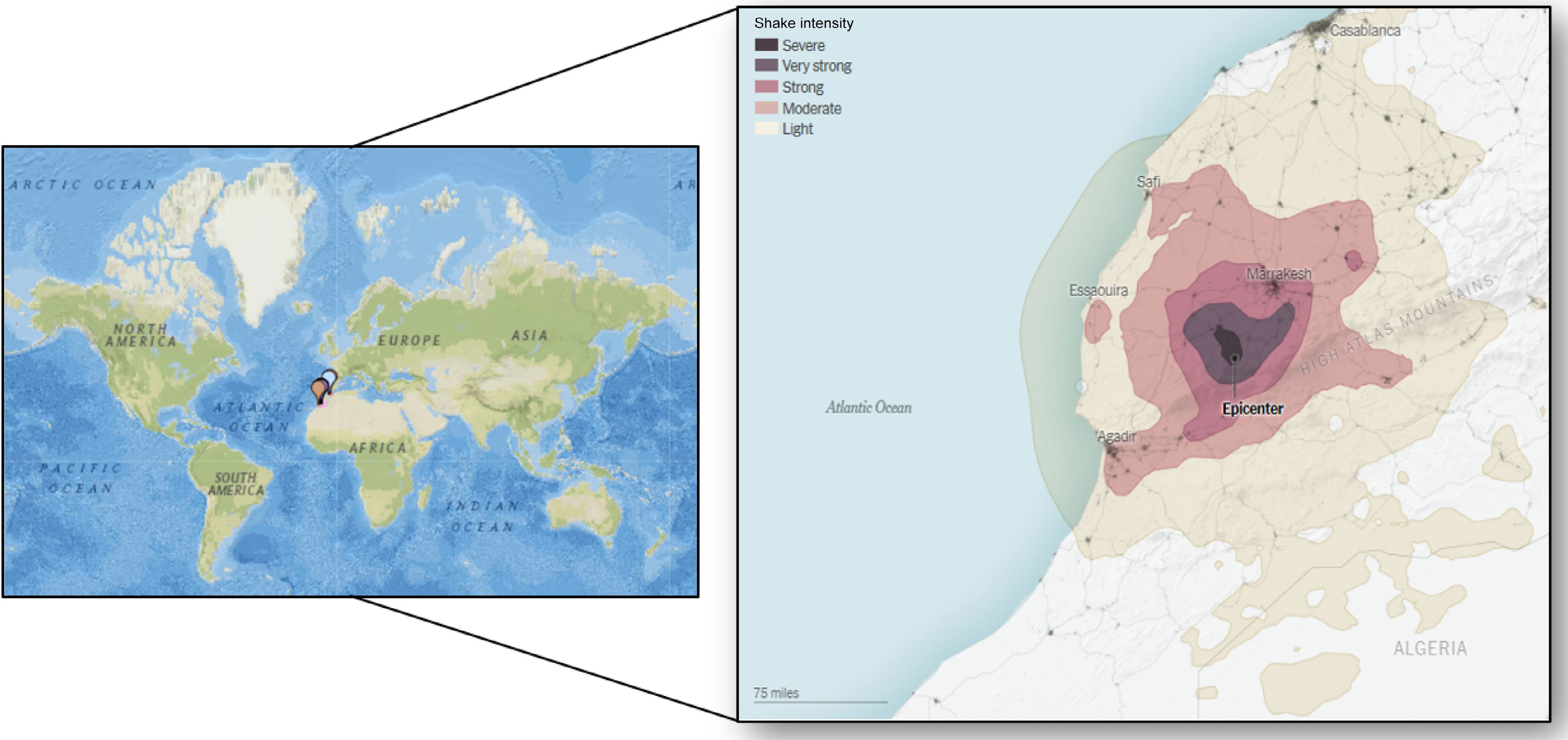
The specific earthquake event that underpins this study occurred on September 08, 2023, when a magnitude-6.8 earthquake struck at 11:11 PM local time. This seismic event had its epicenter situated approximately 45 miles (72 km) southwest of Marrakech, a major city in Morocco, within the Al Haouz province (right panel of Fig. 4). The earthquake's focus was relatively shallow, occurring at a depth of only 11.2 miles (18 km) below the surface, as reported by the United States Geological Survey. This shallow depth resulted in more significant shaking at the Earth's surface, intensifying the impact on the local region[1, 53].
The earthquake caused widespread damage and loss of life in the region. According to the Moroccan government, the earthquake resulted in over 2,800 deaths and more than 2,500 injuries[54]. The city of Marrakech, a UNESCO World Heritage site, was particularly affected, with many historic sites damaged or destroyed[55]. The Kutubiyya Mosque, Marrakech's crown jewel, remained standing after the quake, but the Kharbouch Mosque and parts of the old city walls collapsed[56]. In total, there were over 392 damaged structures and over 347 potentially damaged structures in the area[53].
The location of this earthquake is of particular importance to our study as it exemplifies the seismic vulnerability and risk associated with the Moroccan context. This earthquake event serves as a focal point for assessing and improving earthquake management strategies in this region, particularly in areas prone to seismic activity such as the Al Haouz province.
Understanding Multi-Criteria Decision-Making (MCDM) in disaster risk reduction
-
MCDM, or Multi-Criteria Decision-Making, is a structured approach to decision-making that considers multiple criteria or attributes simultaneously. It acknowledges that in many real-world scenarios, decisions are not based on a single criterion but involve several factors that may have different levels of importance or significance[59]. MCDM provides a framework for:
1. Identifying Criteria: Defining and selecting the relevant criteria or factors that are essential in the decision-making process.
2. Assigning Weights: Assigning relative weights or importance values to each criterion to reflect its significance in the decision. This step acknowledges that some criteria may carry more weight than others.
3. Evaluating Alternatives: Assessing various alternatives or options based on their performance with respect to each criterion.
4. Aggregating and Ranking: Combining the evaluations for all criteria to generate an overall ranking or score for each alternative, allowing for comparison and decision-making.
In the context of disaster risk reduction, MCDM plays a crucial role in making informed, systematic, and objective decisions to minimize the impact of disasters. When allocating resources for disaster preparedness, response, or recovery, MCDM assists in prioritizing projects or initiatives based on criteria like potential impact reduction, cost-effectiveness, and community resilience. By applying MCDM to disaster risk reduction, decision-makers can make more informed, transparent, and equitable choices that ultimately lead to more effective strategies for reducing the impact of disasters on communities and infrastructure. It helps prioritize actions that save lives, reduce economic losses, and build resilience in the face of natural hazards[60,61].
Key phases in Analytic Hierarchy Process (AHP) as a multi-criteria decision-making model
-
The Analytic Hierarchy Process (AHP) is a powerful Multi-Criteria Decision-Making (MCDM) tool that facilitates complex decision-making by systematically structuring and prioritizing multiple criteria and alternatives[62,63]. Developed by Thomas L. Saaty in the 1970s, MCDM has found extensive utility across various domains, including its role in identifying suitable regions for projects like photovoltaic and concentrated solar power initiatives[64,65], assessing onshore wind energy potential[66], examining the feasibility of offshore wind energy ventures[67], and investigating opportunities for offshore floating photovoltaic installations[68].
Pant et al.[69] investigate the use of artificial intelligence, the Internet of Things, and Blockchain to simplify complex monitoring and maintenance tasks in various systems. It employs the analytical hierarchy process (AHP) to rank health management practices in a smart healthcare system. Four criteria are considered, including a calm state of mind and a good immune system. The study evaluates two alternatives, exercise, and a nutritious diet, finding that a calm state of mind is the most crucial criterion, and inculcating awareness is the least important. The nutritious diet is given a higher weightage of 58%, indicating its superiority over exercise (42%) in weight management. Overall, the research highlights the potential of multi-criteria decision-making methods in addressing real-world problems, offering insights into effective health management practices.
Moreover, the specialized application of MCDM-AHP has extended to the realm of cybersecurity solutions within smart grid environments, demonstrating its integration with artificial intelligence[70,71], as showcased in the recent research conducted by Bouramdane in 2023[36]. Additionally, the same author has applied this approach to assess water management strategies in smart cities[37] including water desalination[72].
In a recent study, Bouramdane[73] conducted a thorough assessment of hydrogen production technologies in Morocco. Their evaluation, utilizing the MCDM-AHP methodology, took into account factors such as technological feasibility, economic viability, environmental impact, and social acceptance. The research identified certain high-performing technologies, including Autothermal Reforming with Carbon Capture and Storage, as well-suited for hydrogen production in Morocco. Additionally, moderate-performing technologies like photovoltaic and concentrated solar power demonstrated promise. However, low-performing technologies may encounter challenges in meeting specified criteria. The study emphasizes the significance of stakeholder perspectives, particularly in renewable penetration scenarios, influencing the suitability of technologies. These insights are crucial for guiding decision-makers toward achieving energy independence and climate goals. For more detailed information on hydrogen technologies, readers are encouraged to consult Bouramdane's work[74−78].
MCDM-AHP offers a structured and mathematically rigorous framework for addressing decision problems with multiple factors and stakeholders[79,80].
Hierarchy-based decision-making
-
At its core, AHP organizes a decision problem into a hierarchical structure consisting of three main levels[81−83]:
● Goal/Objective: At the top level, there is the overarching goal or objective of the decision problem. This represents the ultimate aim or purpose of the decision-making process.
● Criteria: Below the goal, the second level comprises criteria or factors that are relevant to achieving the goal. These criteria are the aspects or dimensions by which the alternatives will be evaluated.
● Alternatives: The lowest level consists of the alternative options or choices available for the decision. These could be potential solutions, strategies, or courses of action.
Pairwise comparisons
-
A key feature of AHP is the systematic use of pairwise comparisons, where decision-makers compare the relative importance or preference of criteria and alternatives in relation to one another. Pairwise comparisons help quantify subjective judgments and capture the relative importance of criteria and alternatives. The pairwise comparison between elements i and j at level k is denoted as
$ a_{ij}^{(k)} $ $ a_{ij}^{(k)} = \frac{1}{a_{ji}^{(k)}} $ Priority vectors
-
To calculate the priority vector for a set of elements at level k, we use the following equations:
$ w_i^{(k)} = \dfrac{1}{n} \sum\limits_{j = 1}^{n} a_{ij}^{(k)} \quad \text{for } i = 1, 2, \ldots, n $ (1) Where,
$ w_i^{(k)} $ The normalized priority vector is obtained by dividing each weight by the sum of all weights:
$ w_i^{(k)} = \dfrac{w_i^{(k)}}{\sum_{i = 1}^{n} w_i^{(k)}} $ (2) Consistency assessment
-
AHP includes a mathematical consistency check to ensure that the pairwise comparison judgments are logical and do not contain inconsistencies or contradictions. This feature enhances the reliability of the decision-making process. The consistency ratio (CR) is used to check the consistency of judgments. It is calculated as follows:
$ CR = \dfrac{\lambda_{\max} - n}{n - 1} $ (3) Where,
$ \lambda_{\max} $ Mathematical aggregation
-
After obtaining the pairwise comparison matrices, AHP employs mathematical methods, specifically eigenvector and eigenvalue calculations, to aggregate the judgments and determine the relative weights or priorities of criteria and alternatives.
Final decision and sensitivity analysis
-
With the calculated weights, AHP allows for the ranking of alternatives based on their overall performance with respect to the criteria. Sensitivity analysis can be conducted to assess the robustness of the decision to changes in judgments or criteria weights.
The AHP framework for effective earthquake risk management
-
Applying the Analytic Hierarchy Process (AHP) to earthquake management involves a systematic series of steps to prioritize and make informed decisions regarding earthquake preparedness, mitigation, response, and recovery strategies. The key steps involved in using AHP for earthquake management are[80] (Fig. 5):
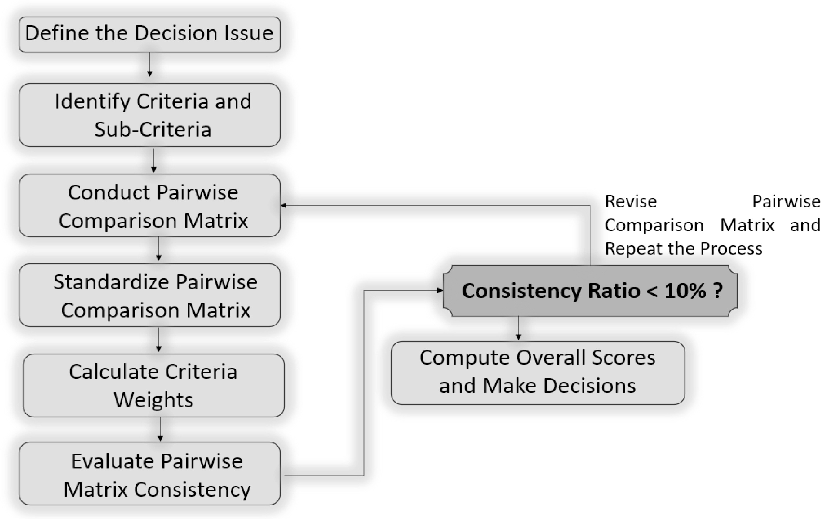
Figure 5.
Analytical Hierarchy Process (AHP) algorithm: a systematic method for evaluating and prioritizing earthquake management strategies using multiple criteria. Source: the author's own elaboration.
1. Define the Decision Problem: We clearly articulate the specific decision problem related to earthquake management. This could involve selecting the most effective mitigation strategy, prioritizing resource allocation for response efforts, or evaluating different preparedness initiatives.
2. Establish the Hierarchy: We develop a hierarchical structure that breaks down the decision problem into three main levels: goal/objective, criteria, and alternatives.
● Goal/Objective: We define the overarching goal of earthquake management as 'minimize the impact of earthquakes on lives and infrastructure'.
● Criteria: We identify the criteria that will be used to evaluate the alternatives.
● Alternatives: We list the available options or strategies for earthquake management.
3. Pairwise Comparisons: For each pair of criteria and alternatives within the hierarchy, we conduct pairwise comparisons to determine their relative importance or performance. We use a scale from 1 to 9, where 1 means both elements are equally important or perform equally, and 9 indicates extreme importance or performance difference[36] (Table 1). Decision-makers or experts should provide their judgments on these comparisons. These judgments can be collected through surveys or interviews.
Table 1. Pairwise comparison matrix between criteria.
C1 C2 C3 C4 C5 C6 C7 C8 C1 1 3 2 2 1 2 2 3 C2 1/3 1 2 2 3 1 1 1/3 C3 1/2 1/2 1 2 1/2 2 1 1/2 C4 1/2 1/2 2 1 2 1 2 1 C5 1 3 1/2 1/2 1 1/2 1/2 1 C6 1/2 1 1/2 1/2 2 1 1 1/2 C7 1/2 1/2 1 2 1/2 2 1 1/2 C8 1/3 3 1/2 1/2 1/3 1/2 1/2 1 In this study, the judgments used to conduct pairwise comparison matrices are obtained from a combination of logic and a comprehensive literature review, rather than solely relying on expert opinions. This approach enhances the objectivity and transparency of the decision-making process, particularly when expert consensus is challenging to obtain or when there is a need to incorporate a broader range of perspectives.
4. Create Pairwise Comparison Matrices: We transform the judgments obtained from pairwise comparisons into matrices. Each matrix represents the relative importance or performance of one set of criteria or alternatives compared to another. Then, we normalize these matrices to ensure they have consistent row or column sums, reflecting the relative weights.
5. Calculate Priority Weights: We use mathematical methods, such as the eigenvalue-eigenvector method, to calculate the priority weights for criteria and alternatives. These weights represent the relative importance or contribution of each criterion and alternative to the overall decision.
6. Consistency Check: We assess the consistency of the pairwise comparisons by calculating a Consistency Ratio (CR). A low CR indicates that the comparisons are consistent and reliable. If the CR exceeds a predefined threshold (typically 0.1 or 10%), it may indicate inconsistencies in the judgments, and reviewers may need to revisit and revise their judgments.
7. Aggregating Scores: We combine the priority weights obtained for criteria and alternatives to compute an overall score for each alternative. The score represents the performance of each alternative concerning the overarching goal and the defined criteria.
8. Rank and Select Alternatives: Based on the aggregated scores, we rank the alternatives from highest to lowest. The alternative with the highest score is the recommended choice for the given earthquake management objective.
9. Decision Communication: Through this research, we communicate the results of the AHP analysis to stakeholders, decision-makers, and the public.
By following these steps, AHP can provide a structured and systematic approach to prioritizing and selecting earthquake management strategies that align with the overarching goal and the preferences of stakeholders involved in the decision-making process.
In selecting the alternatives (A1−A10) and criteria (C1−C8) for our evaluation of earthquake management strategies using the Multi-Criteria Decision-Making Analytic Hierarchy Process (MCDM-AHP), a comprehensive approach was taken to ensure relevance, inclusivity, and alignment with established best practices. The basis for the selection process drew upon a rigorous review of existing literature, international frameworks, and expert opinions in the field of disaster risk reduction and earthquake management[85−87]. Alternatives were chosen to represent a diverse range of strategies commonly employed in earthquake management, with reference to guidelines provided by respected organizations such as the United Nations International Strategy for Disaster Reduction (UNISDR)[88,89] and the Federal Emergency Management Agency (FEMA). Criteria selection was guided by a similar process, with careful consideration given to factors deemed critical for evaluating the effectiveness, feasibility, and impact of earthquake management strategies. Additionally, international standards were consulted to ensure alignment with recognized principles of risk management. Furthermore, discussions with subject matter experts and practitioners in the field helped validate the relevance and comprehensiveness of the chosen alternatives and criteria[90−92]. Overall, the selection process aimed to establish a robust framework that would facilitate a thorough and systematic assessment of earthquake management strategies, contributing to informed decision-making in disaster risk reduction efforts.
Alternatives
-
Earthquake management strategies typically involve a combination of preparedness, mitigation, and response measures:
1. (A1) Building Codes and Construction Standards: Governments often implement strict building codes and standards to ensure that new construction projects are earthquake resistant[7,8]. Retrofitting older buildings to meet these standards is also a common practice.
2. (A2) Early Warning Systems: Some regions have early warning systems that can detect seismic activity and send alerts to people in affected areas seconds to minutes before the shaking begins, allowing them to take protective measures[17,18].
3. (A3) Public Education and Awareness: Public education campaigns inform residents about earthquake risks and safety measures. This includes knowing what to do during an earthquake, creating emergency kits, and having evacuation plans[20,21].
4. (A4) Land Use Planning: Communities may restrict development in earthquake-prone areas or require that new construction projects undergo seismic risk assessments[31].
5. (A5) Emergency Response Plans: Governments and local authorities develop comprehensive response plans, including search and rescue teams, medical facilities, and logistics for providing aid to affected areas[22,93].
6. (A6) International Cooperation: Earthquake-prone regions often collaborate with international organizations and neighboring countries to share information, resources, and expertise in earthquake management[94,95].
7. (A7) Research and Monitoring: Continuous monitoring of seismic activity and geological studies help scientists and authorities understand earthquake patterns and improve prediction and response[96].
8. (A8) Infrastructure Resilience: Critical infrastructure such as bridges, dams, and power plants may be designed or retrofitted to withstand earthquakes[97,98].
9. (A9) Community Preparedness: Encouraging communities to be self-sufficient during the aftermath of an earthquake by stockpiling supplies and organizing community response teams[22,23].
10. (A10) Insurance and Financial Preparedness: Promoting earthquake insurance and financial preparedness measures to help individuals and businesses recover from earthquake-related losses[99,100].
These strategies encompass various aspects of earthquake preparedness, mitigation, and response, emphasizing the importance of a multi-faceted approach to reduce the impact of earthquakes on communities and infrastructure[2,3]. These strategies aim to reduce the impact of earthquakes on lives, property, and the economy by emphasizing prevention, preparedness, and resilience. It is important to note that the specific strategies and their effectiveness can vary from one region or country to another based on their seismic risk, resources, and local conditions[4,5].
Criteria
-
When evaluating earthquake management strategies, various criteria should be considered to assess their effectiveness and suitability for a particular region or context[38,101]. The criteria that can be used to evaluate these earthquake management strategies include:
1. (C1) Effectiveness in Risk Reduction, Timeliness and Responsiveness, and Infrastructure Resilience:
● Efficacy in Risk Reduction: It consists of assessing how well each strategy contributes to reducing the overall risk associated with earthquakes, including minimizing the potential for loss of life, property damage, and economic impact[102].
● Timeliness and Responsiveness: It consists of assessing the ability of strategies, particularly early warning systems and emergency response plans, to provide timely and effective responses during seismic events[103].
● Infrastructure Resilience: Assess the resilience of critical infrastructure, such as bridges and power plants, to withstand earthquakes, ensuring they meet or exceed seismic resilience standards[97, 98].
2. (C2) Cost-Effectiveness: It consists of evaluating the cost-effectiveness of implementing each strategy, considering the financial resources required and the long-term benefits in terms of risk reduction and resilience[104,105].
3. (C3) Inclusivity and Social Equity: Accessibility and Equity: It consists of examining whether the strategies are accessible and equitable, ensuring that all segments of the population, including vulnerable and marginalized communities, can benefit from them[106].
● Community Engagement: It consists of measuring the extent to which communities are actively engaged in the planning and implementation of strategies, promoting community ownership and participation[26].
● Community Preparedness Levels: Evaluate the level of community preparedness and the extent to which communities have stockpiled suppliers, organized response teams, and implemented evacuation plans[22, 23].
● Effectiveness of Public Education: It consists of gauging the effectiveness of public education campaigns in increasing awareness, knowledge, and preparedness among residents[20,21].
● Public Perception and Acceptance: It consists of assessing the perception and acceptance of strategies among the public, as community buy-in and support are crucial for their success[25].
4. (C4) Adaptability and Flexibility:
● Adaptability and Flexibility: It consists of evaluating the adaptability of strategies to changing seismic risks and their flexibility in responding to evolving disaster scenarios[107,108].
● Local Context and Adaptation: Consider the local seismic risk, available resources, and unique characteristics of the region, as strategies may need to be adapted to specific contexts[109].
5. (C5) Environmental Impact and Reduction of Long-Term Vulnerabilities:
● Environmental Impact: It consists of considering the environmental impact of strategies, especially in the case of infrastructure projects, and assessing whether they adhere to sustainable and eco-friendly practices[110,111].
● Reduction of Long-Term Vulnerabilities: It consists of examining how well strategies contribute to reducing long-term vulnerabilities, ensuring that communities are more resilient in the aftermath of earthquakes[112,113].
6. (C6) Compliance with Standards and Insurance Uptake:
● Compliance with Safety Standards: It consists of verifying whether building codes, construction standards, and retrofitting practices meet established earthquake resistance standards and guidelines[114, 115].
● Insurance Uptake: Measure the uptake of earthquake insurance and financial preparedness measures among individuals and businesses in the region[3,116].
7. (C7) Interagency Collaboration: It consists of evaluating the level of collaboration and coordination between government agencies, local authorities, and international partners in implementing strategies[117, 118].
8. (C8) Data Utilization: Determine how well strategies leverage research, monitoring, and data analysis to improve earthquake prediction, response, and recovery efforts[119].
These criteria provide a comprehensive framework for evaluating earthquake management strategies, allowing decision-makers to make informed choices based on their specific goals, priorities, and the unique characteristics of the region or community they are addressing.
Considerations for choosing MCDM-AHP over other models in earthquake management strategy assessment
-
While various Multi-Criteria Decision-Making (MCDM) models exist for assessing earthquake management strategies, the choice of the Analytic Hierarchy Process (AHP) over other models in our study are influenced by several key considerations. This section outlines why MCDM-AHP was selected as the preferred method and highlights some limitations of other MCDM models for our specific research in Morocco.
1. Structured Hierarchy and Pairwise Comparisons: AHP's structured hierarchy and pairwise comparisons make it particularly suitable for our research. In earthquake management, we deal with a wide range of criteria and sub-criteria, and AHP provides a systematic approach for organizing and comparing these elements. The pairwise comparisons allow decision-makers to assess the relative importance of criteria, fostering transparency and a more comprehensive evaluation.
2. Transparency and Stakeholder Involvement: AHP excels in promoting transparency and stakeholder involvement. In the context of earthquake management, where decisions can have profound societal impacts, transparency and the engagement of various stakeholders are critical. AHP allows stakeholders to contribute their judgments and preferences, enhancing the legitimacy of the decision-making process. This participatory approach ensures that the selected strategies align with the values and priorities of the local community.
3. Consistency and Sensitivity Analysis: The consistency check in AHP is a valuable feature for ensuring the reliability of results. It helps identify and rectify inconsistencies in the decision-makers' judgments. Additionally, AHP offers sensitivity analysis, enabling stakeholders to understand how changes in criteria weights affect the final rankings of strategies. This feature enhances the robustness of the decision-making process, which is vital in earthquake management.
4. Adaptability to Varied Contexts: AHP's adaptability is advantageous when assessing earthquake management strategies in diverse regions. Decision-makers can customize the criteria and sub-criteria to suit the specific challenges and priorities of a particular area. This adaptability makes AHP a versatile tool for earthquake management assessment in different contexts.
5. Established Use in Disaster Management: AHP has a history of successful use in disaster management and risk assessment. Its application in various domains, including earthquake risk reduction, has yielded valuable insights and results. This established use provides a level of confidence in the method's effectiveness and reliability.
MCDM techniques provide valuable tools for evaluating complex systems like earthquake management strategies. Among these techniques, AHP stands out as a widely used method due to its ability to handle both qualitative and quantitative criteria. However, various other MCDM techniques offer unique advantages and face distinct challenges when applied to the evaluation of earthquake management strategies.
Technique for Order of Preference by Similarity to Ideal Solution (TOPSIS) ranks alternatives based on their distance from the ideal solution and the furthest distance from the negative ideal solution, providing a clear preference order. Compared to AHP, TOPSIS is relatively straightforward and easy to understand, making it accessible to decision-makers with varying levels of expertise. TOPSIS is less sensitive to changes in input data compared to AHP, resulting in more stable decision outcomes. However, TOPSIS assumes linear relationships between criteria and alternatives, which may not always hold true in complex decision environments. TOPSIS requires all criteria to be expressed in quantitative terms, which may be challenging when dealing with qualitative or subjective criteria. The effectiveness of TOPSIS heavily relies on the proper normalization of criteria values, which can be challenging and subjective in practice[120].
Elimination and Choice Expressing Reality (ELECTRE) allows decision-makers to explicitly model their preferences and trade-offs between criteria, providing a transparent decision-making process. ELECTRE can accommodate non-compensatory preferences, where the performance of an alternative in one criterion cannot compensate for its poor performance in another criterion. ELECTRE's outranking approach provides a robust framework for dealing with uncertainty and imprecision in decision-making. However, ELECTRE requires decision-makers to set several parameters, such as concordance and discordance thresholds, which can be challenging and subjective. Aggregating individual preference relations into an overall ranking can be complex, especially when dealing with a large number of alternatives and criteria. Like other MCDM techniques, ELECTRE is sensitive to criteria weights, and small changes in weights can sometimes lead to significant differences in decision outcomes[121].
Preference Ranking Organization METHod for Enrichment Evaluations (PROMETHEE) offers flexibility in modeling preferences through various preference functions, allowing decision-makers to capture different types of preference structures. PROMETHEE provides visual representations, such as preference graphs and outranking flows, which facilitate interpretation and communication of decision outcomes. PROMETHEE can handle partial rankings and incomplete preference information, making it suitable for decision-making scenarios with limited data availability. However, PROMETHEE involves complex mathematical calculations, particularly when dealing with large decision problems, which can be computationally demanding. Like other MCDM techniques, PROMETHEE requires decision-makers to set parameters, such as preference functions and indifference thresholds, which can introduce subjectivity into the decision process. PROMETHEE lacks robust sensitivity analysis tools to assess the robustness of decision outcomes to changes in input data or parameters[122].
Simple Additive Weighting (SAW) is straightforward and easy to understand, making it accessible to decision-makers with limited technical expertise. SAW involves simple calculations, which can be computationally efficient, particularly for small to medium-sized decision problems. SAW provides transparency in decision-making by directly aggregating criteria weights with performance scores to generate overall rankings. However, SAW assumes linear relationships between criteria and alternatives, which may not always hold true in real-world decision environments. SAW cannot accommodate non-compensatory preferences, where poor performance in one criterion cannot be offset by high performance in another criterion. Eliciting accurate and meaningful criteria weights from decision-makers can be challenging and subjective, potentially leading to biased decision outcomes[123].
In summary, various MCDM techniques offer distinct advantages and face specific challenges in evaluating earthquake management strategies. Decision-makers should carefully assess the suitability of each technique based on the characteristics of their decision problem, the availability of data, and the preferences of stakeholders. Additionally, sensitivity analysis and robustness checks can help mitigate the limitations associated with individual techniques, leading to more informed and reliable decision-making processes.
In conclusion, while other MCDM models have their strengths, the Analytic Hierarchy Process (AHP) was chosen for our study on earthquake management strategies in Morocco due to its structured hierarchy, transparency, stakeholder involvement, consistency checks, adaptability, and established track record in disaster management. These qualities make AHP a powerful tool for addressing the complex and critical challenges of earthquake risk reduction in the Moroccan context.
-
In this section, we present the results of the Multi-Criteria Decision-Making (MCDM), particularly the Analytic Hierarchy Process (AHP), for evaluating earthquake management strategies based on the defined criteria. The pairwise comparison matrices between criteria (Table 1) and between alternatives (Table 2) were used to derive the relative weights of criteria (Fig. 6) and the weighted sums of strategies (Fig. 7).
Table 2. Pairwise comparison matrix between alternatives.
A1 A2 A3 A4 A5 A6 A7 A8 A9 A10 A1 1 2 1/2 1/2 1/2 1/2 1/2 1/2 1/2 1/2 A2 1/2 1 1/2 1/2 2 2 1/2 1/2 1/2 1/2 A3 2 2 1 1 1/2 1/2 1 1 1 1 A4 2 2 1 1 1 1/2 1 1 1 1 A5 2 1/2 1/2 1/2 1 1/2 1/2 1/2 1 1/2 A6 2 1/2 1/2 1/2 1/2 1 1/2 1/2 1 1/2 A7 1/2 1/2 1 1 1/2 1/2 1 1 1 1 A8 1/2 1/2 1 1 1/2 1/2 1 1 1 1 A9 1/2 1/2 1 1 1/2 1/2 1 1 1 1 A10 1/2 1/2 1 1 1/2 1/2 1 1 1 1 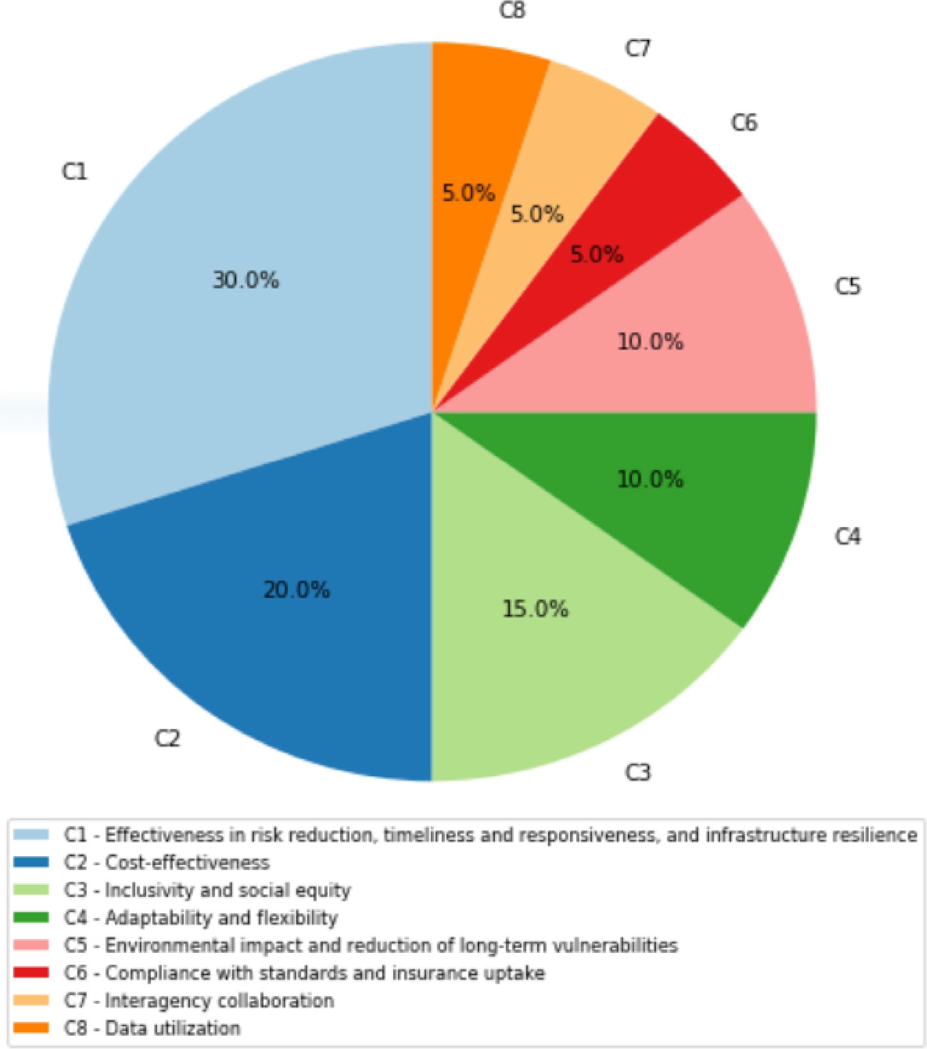
Figure 6.
Relative weights of criteria. Source: Own elaboration based on the methodology section.
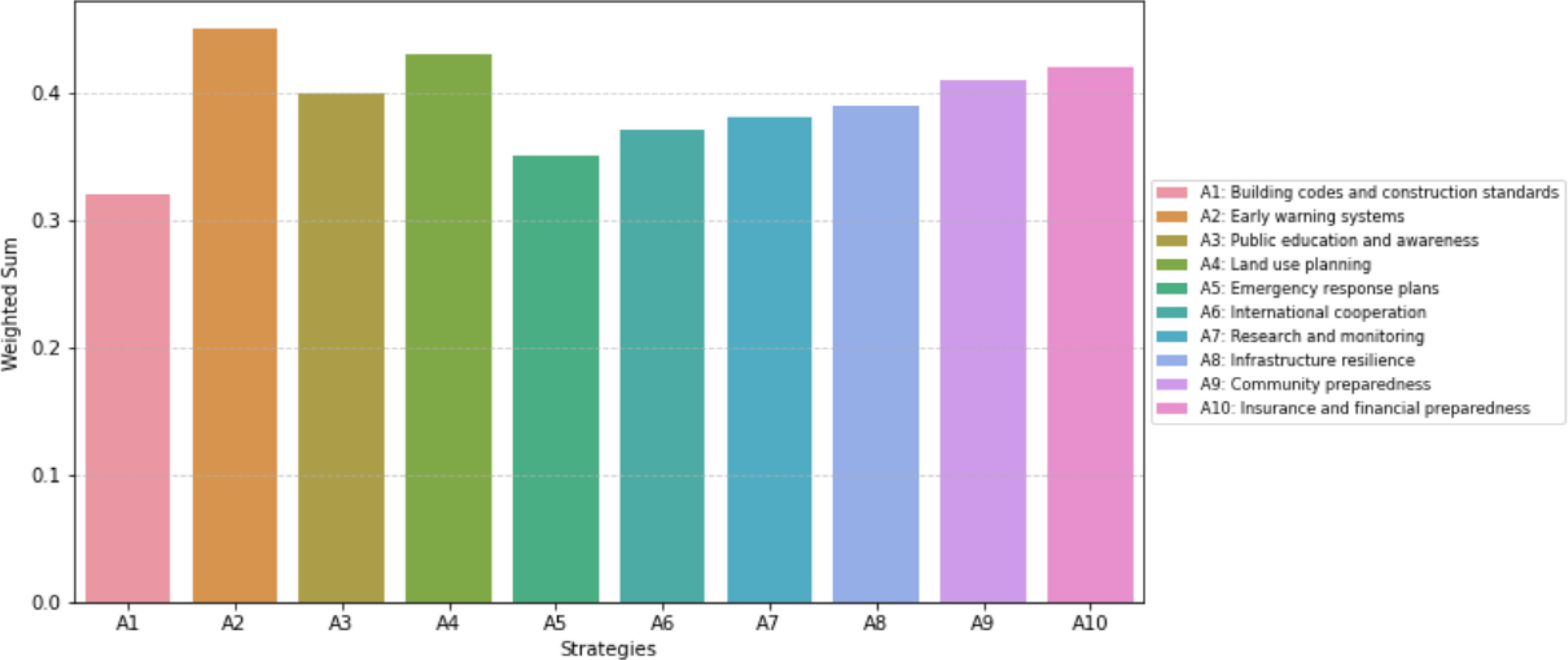
Figure 7.
Weighted sums of earthquake management strategies. Source: Own elaboration based on the methodology section.
Pairwise comparison matrix between criteria
-
The pairwise comparison matrix between criteria (Table 1) is a crucial component of the AHP methodology, and it provides insights into the relative importance or preference of one criterion over another. In this case, the matrix is used to compare and assess the importance of each criterion in evaluating earthquake management strategies.
Each row and column in the matrix (Table 1) corresponds to one of the criteria (C1 to C8) used for evaluating earthquake management strategies.
The numbers in the matrix represent the relative importance or preference of one criterion compared to another. The comparisons are made using a scale that ranges from 1 to 3, with 1 indicating equal importance or preference and values greater than 1 indicating that one criterion is considered more important or preferable than the other. Conversely, values less than 1 indicate that one criterion is considered less important or preferable than the other.
C1 (effectiveness in risk reduction) has a relative importance score of 1 compared to itself, as it is the diagonal element of the matrix. This means that C1 is considered equally important as itself, which is expected.
C2 (cost-effectiveness) has a relative importance score of 3 when compared to C1. This suggests that cost-effectiveness (C2) is considered significantly more important than effectiveness in risk reduction (C1) in the context of evaluating earthquake management strategies.
C3 (inclusivity and social equity), which includes accessibility and equity, community engagement, community preparedness levels, effectiveness of public education, public perception, and acceptance, has a relative importance score of 2 when compared to C1. This indicates that C3 is considered somewhat more important than C1.
C4 (adaptability and flexibility) has a relative importance score of 1/2 when compared to C1, suggesting that C1 is considered more important than C4 in the context of evaluating earthquake management strategies.
C5 (environmental impact and reduction of long-term vulnerabilities) is considered equally important to C1 with a score of 1.
C6 (compliance with standards and insurance uptake) has a relative importance score of 2 when compared to C1.
C7 (interagency collaboration) has a relative importance score of ½ when compared to C1. This means that interagency collaboration (C7) is considered less important than effectiveness in risk reduction (C1) in the context of evaluating earthquake management strategies.
C8 (data utilization) has a relative importance score of 3 when compared to C1, indicating that data utilization (C8) is considered significantly more important than effectiveness in risk reduction (C1).
Pairwise Comparison Matrix Between Alternatives
-
The pairwise comparison matrix between alternatives (Table 2) is a critical component of the AHP methodology. It is used to compare and assess the relative importance or preference of one alternative over another in the context of evaluating earthquake management strategies.
Each row and column in the matrix (Table 2) corresponds to one of the earthquake management strategies (A1 to A10).
The numbers in the matrix represent the relative importance or preference of one alternative compared to another. The comparisons are made using a scale that ranges from 1 to 2, with 1 indicating equal importance or preference and 2 indicating that one alternative is considered more important or preferable than the other. Conversely, values less than 1 indicate that one alternative is considered less important or preferable than the other.
A1 (building codes and construction standards) has a relative importance score of 1 compared to itself, as it is the diagonal element of the matrix. This means that A1 is considered equally important as itself, which is expected.
A2 (early warning systems) has a relative importance score of 2 when compared to A1. This suggests that early warning systems (A2) are considered more important than A1 (building codes and construction standards) in the context of earthquake management strategies.
A3 (public education and awareness) has a relative importance score of ½ when compared to A1. This indicates that A1 is considered more important than A3.
A4 (land use planning) has a relative importance score of ½ when compared to A1, suggesting that A1 is considered more important than A4.
A5 (Emergency Response Plans) has a relative importance score of ½ when compared to A1.
A6 (international cooperation) has a relative importance score of ½ when compared to A1.
A7 (research and monitoring) has a relative importance score of ½ when compared to A1.
A8 (infrastructure resilience) has a relative importance score of ½ when compared to A1.
A9 (community preparedness) has a relative importance score of ½ when compared to A1.
A10 (insurance and financial preparedness) has a relative importance score of ½ when compared to A1.
Consistency assessment of analysis results
-
The consistency of the results in the Multi-Criteria Decision-Making (MCDM)-Analytic Hierarchy Process (AHP) is a crucial step to ensure the reliability of the derived priorities. It helps determine if the pairwise comparisons made by the decision-maker are consistent with each other.
Two Consistency Indices (CI) are calculated for the pairwise comparison matrices, one for criteria and another for alternatives. These indices assess the degree of consistency in the comparisons. Typically, a CI below a certain threshold is considered acceptable.
For the pairwise comparison matrix between criteria, we calculate a Consistency Index (CI) of 0.03. This CI value represents the degree of inconsistency in the comparisons made among the criteria. Since this CI is below the acceptable threshold of 0.1, we can conclude that the results are consistent. In other words, the comparisons made between criteria are sufficiently consistent and can be relied upon for further analysis.
Moving on to the pairwise comparison matrix between alternatives, we calculate a Consistency Index (CI) of 0.02. This CI value assesses the consistency of the comparisons made among the earthquake management strategies. Similar to the criteria matrix, the CI for alternatives is also below the acceptable threshold. Therefore, we can confidently conclude that the results of the comparisons between alternatives are consistent.
In summary, both the pairwise comparison matrix between criteria and the pairwise comparison matrix between alternatives have consistency indices below the acceptable threshold, indicating a high degree of consistency in the decision-maker’s judgments. This consistency enhances the reliability of the priorities and weights assigned to criteria and alternatives in the MCDM-AHP analysis, making the results a robust foundation for earthquake management strategy evaluation and decision-making.
Criteria importance and weighting analysis
-
The relative weights of criteria represent their importance or significance in the context of evaluating earthquake management strategies. These weights are essential because they reflect the priorities assigned to each criterion by the decision-maker or stakeholders (Fig. 6).
C1 (effectiveness in risk reduction) is assigned a relatively high weight (0.3), indicating that it is considered an important criterion in evaluating earthquake management strategies. This criterion holds significant importance in the decision-making process.
C2 (cost-effectiveness) is assigned a medium weight (0.2), suggesting that it is moderately important but not as critical as C1. Cost-effectiveness is a relevant consideration but does not carry as much weight as risk reduction effectiveness.
C3 (accessibility and equity, community engagement, community preparedness levels, effectiveness of public education, public perception, and acceptance) is assigned a medium weight (0.15), indicating its moderate importance in the evaluation process. It is considered somewhat important but not as critical as the top two criteria.
C4 (adaptability and flexibility) is assigned a low weight (0.1), suggesting that it is considered less important compared to the previous criteria. It is still relevant but not a primary focus of the evaluation.
C5 (environmental impact and reduction of long-term vulnerabilities) is also assigned a low weight (0.1), indicating that while environmental impact and long-term vulnerability reduction are relevant, they are not as critical as the top criteria.
C6 (compliance with standards and insurance uptake) is assigned a very low weight (0.05), signifying that it is considered of low importance in the evaluation process. It is a relatively minor consideration.
C7 (interagency collaboration) is assigned a very low weight (0.05), similar to C6, indicating that interagency collaboration is of low importance compared to other criteria.
C8 (data utilization) is also assigned a very low weight (0.05), suggesting that data utilization is considered of minimal importance in the overall evaluation of earthquake management strategies.
Understanding these weightings helps decision-makers prioritize their efforts and allocate resources accordingly when evaluating and selecting earthquake management strategies.
Strategy prioritization and weighted sum analysis
-
The weighted sums of earthquake management strategies represent the overall evaluation of each strategy, taking into account the specified criteria and their relative weights. These weighted sums help identify which strategies are more preferred or effective in the context of mitigating earthquake risks (Fig. 7).
Early warning systems (A2) have the highest weighted sum of 0.45 among the strategies, making them the most preferred or effective strategy in earthquake risk reduction based on the specified criteria and their weights. A2 is the top-rated strategy.
Land use planning (A4) received a weighted sum of 0.43, signifying its effectiveness as a strategy for earthquake risk reduction. It is considered a competitive option.
Insurance and financial preparedness (A10) have a weighted sum of 0.42, indicating their effectiveness in earthquake risk reduction. They are one of the top-rated strategies.
Community preparedness (A9) received a weighted sum of 0.41, indicating that it is a strong strategy and one of the top-rated options in earthquake risk reduction efforts.
Public Education and Awareness (A3) has a weighted sum of 0.4, indicating that it is a strong strategy with a substantial overall score. It is a valuable component of earthquake risk reduction efforts.
Infrastructure resilience (A8) has a weighted sum of 0.39, indicating its effectiveness as a strategy for earthquake risk reduction. It is a competitive option.
Research and Monitoring (A7) received a weighted sum of 0.38, indicating that they are a strong strategy in earthquake risk reduction efforts. They provide valuable insights and data for decision-making.
International cooperation (A6) has a weighted sum of 0.37, indicating its effectiveness in earthquake risk reduction. It is a competitive strategy.
Emergency response plans (A5) received a weighted sum of 0.35, indicating that they are a valuable strategy but not the top-rated option. They play a crucial role in disaster management.
Building codes and construction standards (A1) have a weighted sum of 0.32, indicating that this strategy received a moderate overall score when considering the criteria and their relative importance. It is a viable strategy but not the highest-rated option.
In summary, based on the weighted sums, early warning systems (A2), land use planning (A4), insurance and financial preparedness (A10), community preparedness (A9), and public education and awareness (A3) emerge as the top-rated earthquake management strategies. These strategies received the highest overall scores when considering the criteria and their relative importance. However, the other strategies also play essential roles and are valuable components of a comprehensive earthquake risk reduction approach.
-
In this study, we applied the Multi-Criteria Decision Making - Analytic Hierarchy Process (MCDM-AHP) methodology to assess and prioritize various earthquake management strategies in Morocco. These strategies play a critical role in reducing the impact of seismic events on communities and infrastructure. The evaluated strategies encompass a wide range of approaches, from structural measures like Building Codes and Construction Standards (A1) to community-focused initiatives such as Public Education and Awareness (A3) and insurance-based strategies like Insurance and Financial Preparedness (A10).
Interpreting criteria importance
-
Our analysis began by defining a set of criteria (C1–C8) that encompassed multiple dimensions of earthquake risk reduction, including effectiveness, cost-effectiveness, community engagement, and environmental impact. Through pairwise comparisons and the determination of relative weights, we uncovered valuable insights into the priorities of stakeholders and decision-makers.
Effectiveness in risk reduction (C1) emerged as the most critical criterion, holding the highest relative weight. This underscores the fundamental importance of strategies that directly mitigate seismic hazards and protect lives and assets. Cost-effectiveness (C2) and inclusivity and social equity (C3) also carried substantial importance, reflecting the need for efficient resource allocation and strategies that promote community engagement and adaptability (Fig. 6).
Prioritizing strategies
-
The weighted sums of the earthquake management strategies shed light on their overall effectiveness when considering the criteria and their relative weights.
Early warning systems (A2) emerged as the top-rated strategy, signifying their pivotal role in earthquake risk reduction efforts (Fig. 7). The timely dissemination of information through these systems allows for prompt evacuation and preparedness, ultimately mitigating the impact of seismic events. This underscores the critical importance of investing in and strengthening early warning infrastructure. It is crucial to emphasize that while early warning systems play a pivotal role in saving lives and minimizing damage during seismic events, they should not be viewed as a standalone solution. The paramount importance of earthquake-resistant construction[124] and comprehensive disaster preparedness strategies[125] cannot be overstated. These foundational elements are essential for building long-term resilience and ensuring the effectiveness of the overall earthquake risk reduction framework. Early warning systems, when integrated with robust construction practices and thorough preparedness measures form a synergistic approach that significantly enhances our ability to mitigate the impact of earthquakes and safeguard communities.
Land use planning (A4) also proved highly effective in the overall earthquake management strategy. Proper urban planning and zoning regulations contribute significantly to minimizing vulnerabilities, ensuring that new constructions adhere to seismic safety standards, and reducing the risk of infrastructure collapse during earthquakes. This highlights the need for proactive measures in urban development to enhance overall resilience.
Insurance and financial preparedness (A10) emerged as another key component of effective earthquake risk reduction. Financial resilience is crucial for swift recovery post-disaster, and insurance mechanisms play a vital role in supporting affected communities. Integrating insurance and financial preparedness into overall disaster management strategies is essential for building long-term resilience.
Community preparedness (A9) demonstrated high effectiveness, emphasizing the significance of involving communities in disaster management efforts. Engaging communities in training programs, and drills, and fostering a culture of preparedness enhances their ability to respond effectively during earthquakes. Community involvement ensures a collective and coordinated response, ultimately reducing casualties and damage.
Public education and awareness (A3) were identified as integral elements of successful earthquake risk reduction. Educating the public about earthquake risks, safety measures, and evacuation procedures are crucial for fostering a culture of preparedness. Increased awareness empowers individuals and communities to make informed decisions during seismic events, contributing to overall resilience.
In conclusion, the results indicate that a multifaceted approach is essential for effective earthquake risk reduction. Strategies that combine structural measures, community education, and financial preparedness are likely to yield the most comprehensive and sustainable outcomes. Investing in early warning systems, land use planning, insurance mechanisms, community engagement, and public awareness collectively forms a robust framework for mitigating the impact of earthquakes and building resilient communities.
Practical implications for decision-makers in the aftermath of the recent Moroccan earthquake
-
In light of the recent seismic events in Morocco[1], the findings of this comprehensive study carry profound practical implications for decision-makers tasked with enhancing earthquake management strategies in the region. The evaluation of ten distinct earthquake management strategies, ranging from building codes to community preparedness and financial resilience provides a nuanced understanding of their effectiveness against a backdrop of rigorous criteria. In this section, we delineate practical takeaways that decision-makers can implement to bolster earthquake resilience.
First and foremost, decision-makers are urged to prioritize the establishment and enhancement of Early Warning Systems (A2). The study underscores the effectiveness of such systems in providing timely alerts, enabling better preparedness, and facilitating swift responses to mitigate immediate risks during earthquakes. By investing in and optimizing these systems, decision-makers can significantly reduce the potential impact of future seismic events.
Additionally, community engagement, as reflected in Community Preparedness (A9), emerges as a crucial factor in long-term resilience. Decision-makers should emphasize initiatives that empower communities through education, training, and fostering a sense of collective responsibility. Informed and prepared communities are not only more resilient in the face of disasters but also contribute significantly to the overall effectiveness of emergency response efforts.
Financial preparedness, highlighted in the Financial Preparedness (A10) strategy, should be recognized as a cornerstone of earthquake risk reduction. Decision-makers are encouraged to advocate for and facilitate the adoption of insurance mechanisms at both individual and community levels. This proactive approach can provide critical financial support in the aftermath of earthquakes, aiding in the recovery and reconstruction process.
Moreover, decision-makers should embrace a tailored approach that considers the specific vulnerabilities and conditions of different regions within Morocco. Recognizing the diversity of challenges faced by communities, an approach that adapts strategies to address unique needs is imperative. This tailored perspective ensures that resources are allocated judiciously and interventions are precisely calibrated to the distinct characteristics of each locality.
Continuous monitoring and research (A7) should be prioritized to enhance the understanding of earthquake risks, vulnerabilities, and the effectiveness of implemented strategies. Decision-makers should allocate resources to support ongoing research efforts, enabling them to stay abreast of evolving circumstances, emerging risks, and areas requiring adjustments or improvements.
Promoting interagency collaboration (C7) is fundamental for a unified and effective response to earthquakes. Decision-makers should facilitate coordination and information-sharing among governmental bodies, non-governmental organizations, and other stakeholders. This collaborative approach ensures that resources are pooled efficiently, expertise is shared, and response efforts are streamlined.
Encouraging the development of strategies that are adaptable and flexible (C4), decision-makers should be prepared to modify approaches based on evolving circumstances, emerging risks, and feedback from ongoing evaluations. This proactive stance ensures that earthquake management strategies remain responsive and effective in the face of dynamic challenges.
Lastly, public education and awareness campaigns (A3) must be strengthened to enhance the understanding of earthquake risks, safety measures, and the importance of community participation. Informed and prepared communities not only contribute to their resilience but also play a vital role in reducing the overall impact of earthquakes on society.
In conclusion, the practical implications derived from this study are tailored to guide decision-makers in prioritizing and implementing effective earthquake management strategies in the aftermath of the recent Moroccan earthquake. Emphasizing adaptability, collaboration, and continuous monitoring, these recommendations aim to contribute to a more resilient and responsive approach to earthquake risk reduction and emergency management in Morocco.
Limitations and future research directions
-
It is essential to acknowledge the limitations of this study. The effectiveness of earthquake management strategies may be influenced by factors not considered in our analysis. Future research could explore the integration of climate change impacts[126,127] (SMRY)[128−134] [Chapter 5][135] (SMRY[136,137]) and the dynamic nature of risk in decision-making processes[138−141]. Indeed, it is crucial to acknowledge the evolving landscape of natural disasters and their interactions. Our study primarily focused on earthquake management strategies, but the integration of climate change impacts is a critical consideration. Emerging research[142,143] emphasizes the interconnectedness between climate change and seismic activity. Climate change can influence seismic hazards through various mechanisms, including changes in groundwater levels and the stress on tectonic plates. While our analysis provided valuable insights into earthquake risk reduction, future research should delve deeper into the intricate relationship between climate change and seismic events. This includes exploring how climate-induced factors, such as extreme weather events, may amplify earthquake risks and influence the effectiveness of our evaluated strategies.
Additionally, involving a broader range of stakeholders and experts in the pairwise comparisons could enhance the robustness of the results. Finally, further investigation into the implementation challenges and barriers associated with each strategy is needed to inform practical decision-making.
In conclusion, this study provides valuable insights into the prioritization of earthquake management strategies using MCDM-AHP. The findings emphasize the importance of a balanced and context-specific approach to mitigate earthquake risks effectively. Decision-makers should consider the unique characteristics of their regions and communities when selecting and implementing strategies to ensure resilience and preparedness in the face of seismic events.
Comparative analysis of earthquake management strategy evaluations: insights from various studies
-
In comparing the results of our rigorous assessment of earthquake management strategies in Morocco, specifically within the Al Haouz province, with existing studies, a nuanced understanding of commonalities and divergences emerges. Our study evaluated ten distinct strategies (A1 to A10) against comprehensive criteria (C1 to C8), shedding light on the intricacies of seismic risk reduction. This comparative analysis seeks to contextualize our findings within the broader landscape of earthquake management research.
In the realm of earthquake management strategies, a notable gap exists in the literature concerning rigorous evaluations specific to the Moroccan context, particularly within the Al Haouz province. Despite the critical seismic vulnerabilities in the region, there has been a dearth of comprehensive studies assessing the effectiveness of distinct earthquake management strategies against a comprehensive set of criteria. The majority of existing research tends to be geographically dispersed, focusing on varied methodologies and specific aspects of earthquake risk. This knowledge gap underscores the originality and significance of our study, which not only addresses this critical void but also pioneers a thorough evaluation of ten distinct strategies against a wide-ranging set of criteria (C1 to C8). By doing so, our study not only contributes to the broader discourse on earthquake risk reduction but also offers a novel and context-specific perspective that can guide future research and policy frameworks in seismic-prone regions. The emphasis on the Al Haouz province further enhances the relevance and applicability of our findings, providing a unique lens into earthquake management in Morocco.
In comparing the outcomes of our earthquake management strategy assessment in Morocco with the study conducted in Penang, Malaysia[144], notable distinctions and similarities emerge. While our research focused on evaluating ten distinct earthquake management strategies in a seismic-prone region, the Malaysian study concentrated on earthquake potential zones, vulnerability, and risk using Xtreme Learning Machine (XLM) and Multi-Criteria Decision Making (MCDM) modeling. Despite differences in geographical context and specific objectives, both studies underscore the pivotal role of early warning systems in seismic risk reduction. In our Moroccan study, Early Warning Systems (A2) emerged as a top-rated strategy, aligning with the significance attributed to them in the Malaysian study. Additionally, the emphasis on community preparedness and financial resilience in our findings resonates with the Malaysian study's recognition of vulnerability conditions in densely populated areas. These parallels highlight the global consensus on the effectiveness of certain strategies and emphasize their importance across diverse seismic contexts, providing valuable insights for the development of robust earthquake risk management strategies worldwide.
In juxtaposing our earthquake management strategy assessment in Morocco with the study focused on disaster mitigation in Yalova City Center, Turkey[145], certain thematic parallels and methodological variations emerge. Both studies share a common emphasis on pre-disaster measures and the significance of effective decision-making in the context of earthquake risk management. The Yalova City Center study employs Geographical Information Systems (GIS) and Geographic Information Systems-based MCDM analyses, utilizing Analytic Hierarchy Process (AHP) and Technique for Order Preference by Similarity to Ideal Solution (TOPSIS) to identify earthquake-risky areas. This resonates with our Moroccan study's incorporation of comprehensive criteria (C1 to C8) and the use of a MCDM model. Both studies acknowledge the challenges posed by decision-making in earthquake-sensitive risk planning, highlighting the need for systematic approaches. While our focus in Morocco was on evaluating specific earthquake management strategies, the Yalova study emphasizes the determination of earthquake-risky areas for informed disaster mitigation processes. These complementary perspectives contribute to the broader discourse on earthquake risk reduction, showcasing the diverse methodologies employed globally for effective disaster management.
When comparing our earthquake management strategy assessment in Morocco with the study focusing on the search and rescue operations in disaster management[146], distinct thematic focuses and methodologies become apparent. While our study in Morocco delved into the effectiveness of ten earthquake management strategies, including early warning systems and community preparedness, the disaster management study highlights the critical aspect of search and rescue operations following an earthquake. Both studies share an underlying concern for optimizing disaster response efforts, with our focus on proactive strategies and the disaster management study concentrating on resource allocation for search operations. The Moroccan study provides a comprehensive evaluation of predetermined strategies, whereas the disaster management study introduces a stochastic multi-objective optimization model, acknowledging the uncertainty inherent in disaster conditions. Notably, both studies recognize the need for efficient decision-making processes, with the disaster management study employing stochastic dynamic programming and MCDM techniques, such as TOPSIS and COPRAS, to address the complex ranking problem. Together, these studies contribute diverse perspectives to the broader field of disaster risk reduction and emergency response planning.
When comparing our earthquake management strategy assessment in Morocco with the study focusing on the optimal site selection for temporary housing in Tehran's District 6 post-earthquake[147], several common threads and distinctive considerations emerge. While our study in Morocco evaluates a range of earthquake management strategies, the Tehran study concentrates on the critical aspect of temporary housing site selection, emphasizing the potential consequences of inappropriate choices. Both studies underscore the importance of strategic planning in disaster management, with our focus on predefined strategies and the Tehran study addressing the need for systematic site selection based on specific criteria. Both studies recognize the multifaceted nature of decision-making in disaster-prone areas, with the Tehran study employing MCDM methods, particularly TOPSIS, to assess and prioritize potential locations. Notably, both studies highlight the significance of considering various criteria, such as accessibility, proximity to service centers, land use, and proximity to faults, albeit in different contexts. The findings from the Tehran study stress the importance of subway stations, parks, and green spaces for temporary housing, echoing the importance of community-centric and accessible locations in disaster response. Together, these studies contribute diverse perspectives to the broader field of earthquake risk reduction and emergency response planning, emphasizing the need for both proactive strategies and efficient post-disaster interventions.
When comparing our earthquake management strategy assessment in Morocco with the study detailing the deployment of real-time seismic and sea-level monitoring networks in the country[45], a complementary relationship emerges. Our study focused on evaluating earthquake management strategies, including early warning systems, while the seismic and sea-level monitoring study underscores the importance of proactive infrastructure for real-time data acquisition and rapid response. Both studies share a common goal of enhancing earthquake risk management but approach it from different angles. The deployment of seismic networks, strong-motion instruments, and tide gauges exemplify a robust and technologically advanced approach to monitoring seismic activities and potential tsunamis in Morocco. This real-time surveillance system, with a 24/7 monitoring setup, aligns with the emphasis on effectiveness in risk reduction (C1) in our study. The collaborative nature of these efforts, including satellite transmission and central recording units, showcases a comprehensive strategy for earthquake preparedness, response, and early warning. Together, these studies contribute to a holistic understanding of earthquake risk management, with our study providing insights into broader strategies and the monitoring study highlighting the critical role of technological infrastructure in reducing seismic risks.
While our earthquake management strategy assessment in Morocco primarily focuses on evaluating strategies to mitigate seismic risks, the study[148] takes a different angle by examining the epistemological questions of causality and contingency in the aftermath of the 2011 uprisings in the Arab world. The comparative political regime studies and social movement literature explored in this study offer a lens through which to understand the dynamics of revolutionary situations. While our study delves into physical risk management, the mentioned research broadens the discussion to encompass political and social upheavals. Notably, both studies recognize the pervasive impact of uncertainty, acknowledging that it influences various stakeholders, including challengers, incumbents, and ordinary citizens. While our study addresses uncertainties related to seismic events, the other study explores uncertainties within political and social contexts. These differing perspectives highlight the diverse challenges and uncertainties faced in both natural and socio-political realms, underscoring the need for comprehensive and adaptive strategies in risk management across different domains.
In synthesizing these comparisons, it becomes evident that while contextual factors and methodological nuances exist, there is a remarkable alignment in the recognition of certain strategies' effectiveness across diverse earthquake management studies. The convergence of Early Warning Systems, community involvement and financial resilience underscores the robustness of these approaches in building resilient communities in seismic-prone regions. As we collectively advance our understanding of earthquake management, these shared insights can inform policy frameworks that transcend geographical boundaries, fostering a global commitment to seismic risk reduction.
In conclusion, our study underscores the convergence observed across various earthquake management studies, highlighting consistent themes and strategies identified to mitigate earthquake risks and enhance resilience. However, it is imperative to recognize the unique contributions of our model within this broader landscape. Our approach incorporates a comprehensive evaluation of earthquake management strategies using Multi-Criteria Decision Making (MCDM) techniques, specifically Analytic Hierarchy Process (AHP), in conjunction with a rigorous literature review. By integrating both quantitative and qualitative insights, our model provides a holistic understanding of the effectiveness, efficiency, and societal impacts of different strategies. Moreover, our methodology emphasizes objectivity and transparency by deriving judgments from a synthesis of logic and literature findings rather than solely relying on expert opinions. This unique aspect enhances the robustness and applicability of our model, offering valuable insights for policymakers, practitioners, and researchers engaged in earthquake risk management efforts.
Relationship between earthquakes and climate change
-
Climate change and earthquakes are related in a number of ways. Climate change can directly and indirectly impact earthquakes, and earthquakes can also impact the climate.
Direct impacts of climate change on earthquakes
-
The interaction between environmental changes and seismic activity encompasses several interconnected factors.
Firstly, sea level rise can increase the weight on the Earth's crust, making it more likely to rupture. This can lead to more earthquakes, especially in coastal areas[149,150] (Fig. 8).
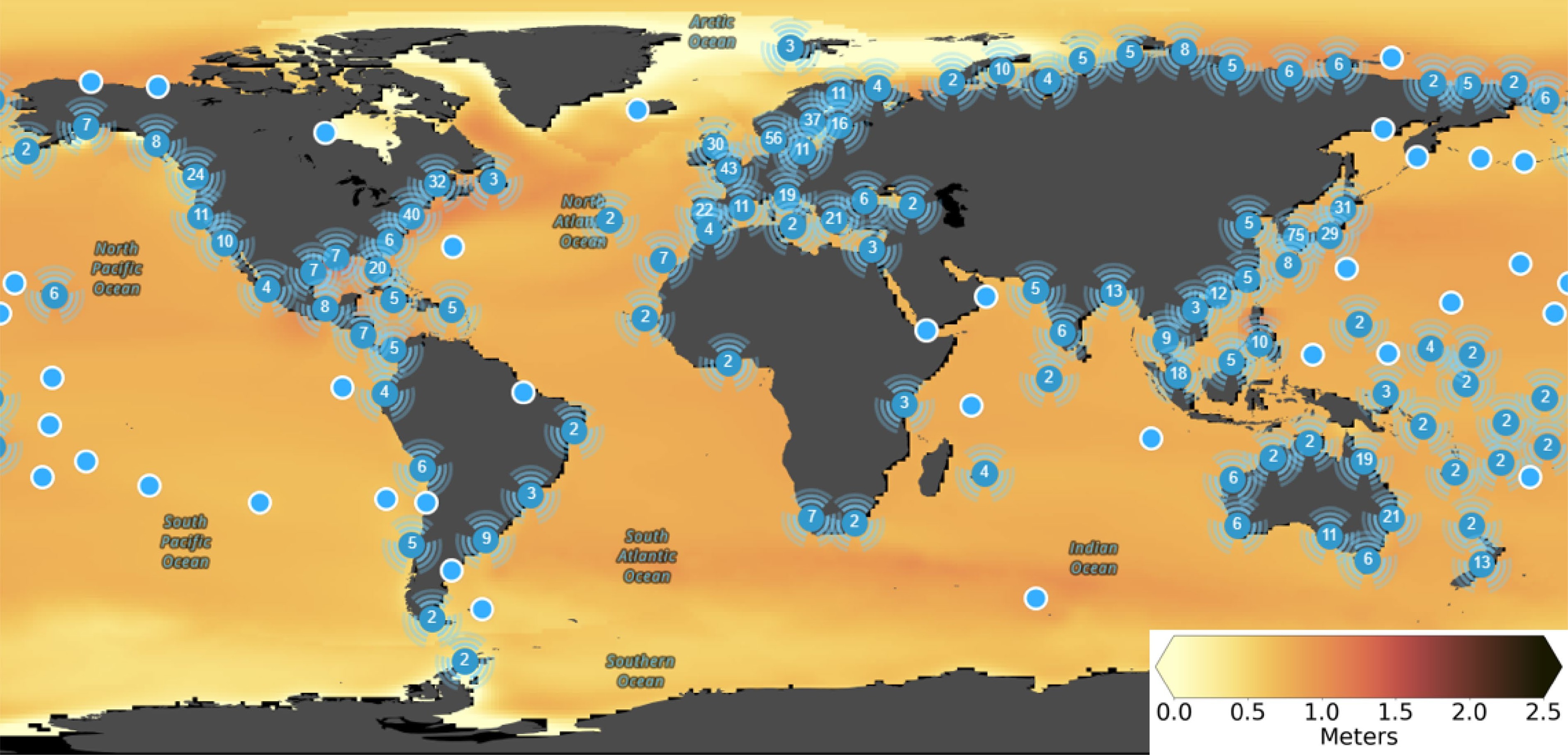
Figure 8.
Median projections of global and regional sea level rise, which is one of the direct impacts of climate change that can exacerbate earthquakes, by the year 2100 under a high-emission, low-mitigation Shared Socioeconomic Pathway (SSP5-8.5) scenario envisioning a future with limited global cooperation on climate change, leading to significant challenges in adaptation and a trajectory towards a warmer and more environmentally stressed world by the end of the 21st century[126]—relative to a 1995−2014 baseline. Sea level rise will not be evenly distributed around the world. The highest rates of sea level rise are projected to occur in Southeast Asia, the Pacific Islands, and the coastlines of North America and Europe. The highest rates of sea level rise are occurring in coastal areas. This is because the weight of the seawater can cause the land to subside, or sink. Sea level rise can make coastal areas more vulnerable to earthquakes, as the weight of the seawater can add additional stress to the Earth's crust, making it more likely to rupture. Source: The Intergovernmental Panel on Climate Change (IPCC) tool (the IPCC, which is a valuable resource for understanding the risks of sea level rise and developing adaptation strategies. It allows users to select different scenarios and time horizons to see how sea level rise is projected to impact different regions around the world[153].
Secondly, the thawing of permafrost can destabilize the ground, making it more likely to collapse and trigger landslides or mudflows. This can also make the ground more susceptible to shaking from earthquakes[151] (Fig. 9).
Figure 9.
The worldwide distribution of permafrost, which is another direct impact of climate change that can exacerbate earthquakes. The figure shows that permafrost is found in the Arctic and Antarctic, as well as in high-altitude regions such as the Himalayas and the Andes. Thawing permafrost can destabilize the ground, making it more likely to collapse and trigger landslides or mudflows. This could also make the ground more susceptible to shaking from earthquakes. Source: Collett et al.[154].
Lastly, alterations in precipitation patterns can lead to more droughts or floods[126]. Droughts can dry out the soil, making it more brittle and more likely to crack. This can make the ground more susceptible to shaking from earthquakes. Floods can saturate the soil, making it heavier and more likely to cause landslides[152].
These interconnected environmental factors emphasize the complex dynamics between Earth's processes and the potential for anthropogenic changes to influence seismic hazards.
Figure 10 illustrates the worldwide distribution of the direct impacts of climate change on earthquakes.
Figure 10.
Global active faults or the places where earthquakes are most likely to occur. Global active faults are a major source of earthquakes. When two plates of the Earth's crust move past each other, the friction can cause the rocks along the fault line to break and release energy, resulting in an earthquake. The size and magnitude of an earthquake depends on the length of the fault line that ruptures and the amount of energy released. This figure shows that the direct impacts of climate change on earthquakes are concentrated in the coastal areas (i.e., sea level rise and storm surge can inundate coastal areas, making them more vulnerable to earthquakes. This is because the weight of the seawater can add additional stress to the Earth's crust, making it more likely to rupture)[149,150], permafrost regions (i.e., thawing permafrost can destabilize the ground, making it more likely to collapse and trigger landslides or mudflows. This could also make the ground more susceptible to shaking from earthquakes)[151], and areas prone to droughts and floods (i.e., changes in precipitation patterns could lead to more droughts or floods. Droughts can dry out the soil, making it more brittle and more likely to crack. This can make the ground more susceptible to shaking from earthquakes. Floods can saturate the soil, making it heavier and more likely to cause landslides)[152]. The map also shows that earthquakes are most common in the Pacific Ring of Fire, which is a belt of seismic activity that surrounds the Pacific Ocean. The Pacific Ring of Fire is home to some of the world's most active volcanoes and earthquake faults. Other regions that are prone to earthquakes include the Mediterranean-Alpine belt, the East African Rift System, and the Himalayan-Tibetan region. Adapted from Mavrouli et al.[155].
Indirect impacts of climate change on earthquakes
-
Climate change has multifaceted indirect impacts on seismic activity, encompassing damage to critical infrastructure, population displacement, and increased poverty.
Climate change can damage infrastructure, such as roads, bridges, and power lines. This can make it more difficult to respond to earthquakes and to recover from their aftermath[156].
Climate change can displace people from their homes, making them more vulnerable to earthquakes. This is because they may be forced to live in temporary housing or in areas that are at higher risk of earthquakes[157,158].
Climate change can increase poverty, making it more difficult for people to afford earthquake-resistant housing and other infrastructure. This could also make it more difficult for people to recover from earthquakes[159].
Overall, the impact of climate change on earthquakes is likely to be complex and far-reaching. Climate change could make earthquakes more frequent and more severe, and it could also make it more difficult to respond to earthquakes and to recover from their aftermath.
Specific instances of climate change impact on earthquakes include the exacerbated severity of the 2015 earthquake in Nepal[160]. It was more severe than it would have been without climate change[161,162]. This is because the thawing of glaciers in the Himalayas has destabilized the ground and made it more susceptible to shaking.
In California, the risk of landslides triggered by earthquakes is increasing due to climate change-induced droughts[163,164].
In coastal areas around the world, sea level rise is making them more vulnerable to earthquakes[150]. For example, in Japan, the 2011 earthquake[165] and tsunami caused more damage than they would have without sea level rise.
Impacts of earthquakes on the climate
-
Earthquakes exert diverse influences on the climate through several mechanisms.
Firstly, seismic activity can release greenhouse gases, including carbon dioxide, and methane, into the atmosphere, thereby contributing to climate change[166,167].
Secondly, earthquakes can reshape the landscape, creating new geographical features such as lakes, mountains, and valleys. These alterations can modify the reflection and absorption of sunlight and heat by the Earth, subsequently impacting the climate[168, 169].
Lastly, seismic events can serve as triggers for volcanic eruptions, releasing substantial amounts of ash and sulfur dioxide into the atmosphere. This volcanic activity has the potential to block sunlight, inducing cooling effects on the planet[152].
The intricate interplay between seismic events and climate processes underscores the need for a holistic understanding of the environmental repercussions associated with earthquakes.
Overall, the relationship between climate change and earthquakes is complex and multifaceted. Climate change can impact earthquakes in several ways, and earthquakes can also impact the climate. It is important to understand these relationships to develop effective strategies for mitigating and adapting to both climate change and earthquakes.
Scientists are still working to understand all of the ways in which climate change and earthquakes are related[142,143]. However, it is clear that these two phenomena are interconnected and that we need to consider both of them when developing policies and plans for the future.
-
The culmination of this research reflects a concerted effort to address the pressing challenges posed by earthquakes, recognizing their profound impact on human societies and built-up environments. Executed within Morocco's Al Haouz province, our study aimed to contribute meaningful insights to the field of earthquake risk reduction by systematically evaluating ten distinct strategies using the Multi-Criteria Decision Making-Analytic Hierarchy Process (MCDM-AHP) methodology.
Our research was guided by fundamental questions: the relative priorities of evaluation criteria, the performance of diverse earthquake management strategies, and the broader implications for risk reduction and emergency preparedness. Adopting the rigorous MCDM-AHP framework, we defined eight criteria (C1–C8) crucial to earthquake risk reduction, derived their relative weights through pairwise comparisons, and evaluated ten strategies (A1–A10), quantifying their overall effectiveness through weighted sums.
Our findings underscore the centrality of effectiveness in risk reduction (C1), closely followed by cost-effectiveness (C2) and inclusivity and social equity (C3). Notably, Early Warning Systems (A2) emerged as the top-rated strategy, highlighting their indispensable role in earthquake risk reduction. Community preparedness (A9) and insurance and financial preparedness (A10) also demonstrated high effectiveness, emphasizing community involvement and financial resilience.
Acknowledging the study's limitations is essential. The effectiveness of earthquake management strategies is influenced by myriad factors not fully considered in our analysis. Future research should explore variables like climate change impacts and dynamic risk. Additionally, broader stakeholder inclusion in pairwise comparisons and research into practical implementation challenges would enhance the result's robustness.
The implications of our research findings bear great significance for decision-makers and practitioners involved in earthquake risk reduction and emergency management, particularly in regions vulnerable to seismic events. Recent events, such as the earthquake that Morocco faced, underscore the pressing need for robust earthquake risk reduction strategies.
Our study's prioritization of earthquake management strategies provides a tangible and timely framework for resource allocation and decision-making in the aftermath of seismic events. The recent earthquake in Morocco serves as a stark reminder of the potential devastation that earthquakes can inflict on communities and infrastructure. The insights gained from our research can guide Moroccan authorities and emergency responders to swiftly and effectively deploy resources and measures to address immediate and long-term challenges.
In light of the recent earthquake experience, the pivotal role of early warning systems (A2) becomes apparent. These systems can offer crucial seconds or even minutes of advance notice, enabling residents to seek safety and authorities to initiate response efforts promptly. Our research reaffirms the significance of investing in and expanding such systems to enhance preparedness and reduce casualties.
The recent seismic event in Morocco further emphasizes the importance of community engagement, a key component of earthquake risk reduction. Strategies such as Community Preparedness (A9) can empower residents with the knowledge and resources to respond effectively to earthquakes. Building resilient communities that are aware of earthquake risks and know how to react can significantly reduce the human toll of such events.
The economic repercussions of the recent earthquake in Morocco highlights the significance of strategies like insurance and financial preparedness (A10). Financial preparedness measures can help individuals and businesses recover more swiftly after an earthquake, reducing the long-term economic impact on affected regions.
While our research was conducted with a broad perspective, the recent earthquake event in Morocco demonstrates the global relevance of our findings. Earthquakes can strike anywhere, and the lessons learned from our prioritization of strategies hold true for decision-makers worldwide. Our research provides a universal roadmap for crafting effective earthquake risk reduction strategies tailored to the unique needs and vulnerabilities of each region.
The future scope of this work lies in the continuous refinement and adaptation of these strategies in response to evolving seismic risks and changing socio-economic landscapes. Further investigation could delve into the integration of emerging technologies and innovative methodologies to enhance the effectiveness and timeliness of these strategies. Additionally, exploring the dynamics of interagency collaboration and community engagement in the implementation of earthquake management measures offers a promising avenue for future research. Furthermore, considering the global context, comparative studies with other seismically active regions may yield insights that could inform and strengthen earthquake resilience strategies internationally. Ultimately, the future trajectory of research in this domain should aim at ensuring a holistic and sustainable approach to earthquake management that is not only effective but also socially equitable, environmentally responsible, and adaptive to the challenges posed by a dynamic and interconnected world.
-
As the sole author of this article, I solely conceptualized, designed, and conducted the research, including data collection, analysis, and interpretation. I am responsible for the drafting and revision of the manuscript. The entire intellectual and creative content of this article, including the research design, methodology, and writing, is the result of my individual efforts.
-
The data used in this study, as well as the detailed methodology adapted, are comprehensively described in the methodology section of this article.
-
The publication of this research article in the journal of Emergency Management Science and Technology (EMST) was made possible without incurring Article Processing Charges (APCs). The author would like to express her appreciation to the editorial board and staff of EMST for their commitment to promoting open access and facilitating the sharing of knowledge within the academic community. The author appreciates the invitation and the opportunity to share this research and insights with the academic community and the readers of the EMST journal. The author also expresses heartfelt appreciation to the editors and the diligent reviewers for their perceptive feedback and thorough review, contributing significantly to the improved clarity of this article.
-
The author declares that there is no conflict of interest.
- Copyright: © 2024 by the author(s). Published by Maximum Academic Press on behalf of Nanjing Tech University. This article is an open access article distributed under Creative Commons Attribution License (CC BY 4.0), visit https://creativecommons.org/licenses/by/4.0/.
-
About this article
Cite this article
Bouramdane AA. 2024. A rigorous evaluation of earthquake management strategies in Morocco's Al Haouz province: a Multi-Criteria Decision-Making methodology. Emergency Management Science and Technology 4: e012 doi: 10.48130/emst-0024-0012 

A rigorous evaluation of earthquake management strategies in Morocco's Al Haouz province: a Multi-Criteria Decision-Making methodology
- Received: 20 December 2023
- Revised: 05 April 2024
- Accepted: 22 April 2024
- Published online: 17 June 2024
Abstract: This article investigates the use of Multi-Criteria Decision-Making (MCDM) methodologies, particularly the Analytic Hierarchy Process (AHP), to address the ongoing challenge of earthquake management in Morocco, focusing on recent seismic events in the Al Haouz province. The study rigorously assesses ten distinct earthquake management strategies in Morocco: A1: building codes and construction standards; A2: early warning systems; A3: public education and awareness; A4: land use planning; A5: emergency response plans; A6: international cooperation; A7: research and monitoring; A8: infrastructure resilience; A9: community preparedness; and A10: insurance and financial preparedness. These strategies are evaluated against a comprehensive set of criteria, including C1 (effectiveness in risk reduction), C2 (cost-effectiveness), C3 (inclusivity and social equity), C4 (adaptability and flexibility), C5 (environmental impact), C6 (compliance with standards and insurance uptake), C7 (interagency collaboration), and C8 (data utilization). The resulting criteria weights reflect their importance, with C1 highly significant (0.3), C2 moderately important (0.2), and C3 also moderately important (0.15), while C4, C5, C6, C7, and C8 hold less significance (0.1 or 0.05). Performance scores rank earthquake management strategies, with A2 achieving the highest score (0.45), followed by A4 (0.43), A10 (0.42), A9 (0.41), and A3 (0.4), while A1 attains a moderate score (0.32), aiding decision-making for earthquake risk reduction. This research emphasizes the critical role of early warning systems in earthquake management, stressing the importance of timely alerts, community engagement, and financial preparedness in Morocco's comprehensive risk reduction strategy, utilizing data-driven decision-making to enhance preparedness, response capabilities, and mitigation measures.